A public(k) notice in a newspaper announcing the opening of the canal
The Welland Canal has gone through many incarnations in its history. Today, five distinct canal-construction efforts are recognized. The retronym First Welland Canal is applied to the original canal, constructed from 1824 to 1829 and 1831 to 1833.
The Great Lakes form an excellent navigation route into the interior of North America. Downstream from Niagara Falls, ships can reach the port city of Montreal without encountering major difficulties. Upstream, the lakes are navigable all the way to the western end of Lake Superior. Early on during the European settlement of North America, lack of other infrastructure made the Great Lakes the premier route to reach the interior of the continent, and later to ship materials and goods from the new frontiers.
The elevations of the Great Lakes, demonstrating the massive elevation difference across the Niagara River.
The Niagara Falls stood as a mighty barrier. To bypass it, a portage road between Queenston, Ontario and Chippawa was used, but the solution was far from optimal. The cargo had to be unloaded, carried 18 km up the Niagara Escarpment, then loaded onto different ships to continue on its way.
The relatively narrow Niagara Peninsula, situated between Lake Ontario and Lake Erie, was a natural match to the idea of bypassing the Falls. Indeed, the idea of a canal across the Peninsula was examined as early as 1799, when a group headed by Robert Hamilton, a Queenston merchant, unsuccessfully petitioned the Legislative Assembly of Upper Canada. Hamilton's plan called for a canal to be constructed between Fort Erie and, perhaps unsurprisingly, Queenston.
In 1816, a young man called William Hamilton Merritt bought a rundown sawmill on the Twelve Mile Creek, and added a grist mill and a store. The Twelve flowed from its source south of the Escarpment to Lake Ontario, but its water levels varied considerably, creating difficulties for Merritt and his mills. In 1818, when the flow was especially low, Merritt pursued the idea of bringing water to his mills from the Welland River.
On a bigger scale, the Erie Canal, dug from the Hudson River through northern New York, was about to reach Lake Erie. The impending completion meant the cargo from upper Great Lakes was about to head down the canal and Hudson River to New York City, bypassing its previous destination, Montreal. At the time, a considerable rivalry existed between Montreal and New York for cargo headed to Europe via ocean-going vessels. All of these factors contributed to the construction of the Welland Canal.
Planning
In 1818, William Hamilton Merritt borrowed an instrument called a water level from Samuel Beckett, a mill owner in St. Johns. Along with George Keefer, John DeCew, and a couple of other neighbours he set out to survey a potential route for a water canal. From the headwaters of the Twelve Mile Creek near present-day Allanburg, they planned a line three kilometers south to meet with the Welland River. A ridge was encountered along the way, and using the instrument, the surveyors calculated it to be 10 metres high. It was actually double that height; the reason for the error is not known.
On July 4, 1818, Merritt organized a meeting in St. Catharines. The outcome was a petition sent to Upper Canada Legislature to provide for construction of a canal between the Twelve Mile Creek and Welland River. Unlike Merritt's original water-canal plan, the petition included plans for allowing boats to cross the Niagara Escarpment. In 1823, Hiram Tibbetts, an engineer, was employed to make a formal survey for the route. He suggested to dig a channel 1.2 metres (4ft) below the surface level of Welland River between present-day Port Robinson and Allanburg, and then follow the Twelve Mile Creek northwest to DeCew's Falls (where John DeCew owned a mill). There, it was suggested to descend the escarpment by an incline railway and continue along the creek to Port Dalhousie to reach Lake Ontario.
On January 19, 1824, an act of the Legislature formed the Welland Canal Company, with a capitalization of $150,000 and Merritt as the financial agent. As part of his fundraising duties, he travelled extensively, including the United States and Great Britain.
Later in 1824, a revised route was put forward for the canal. It travelled from Port Robinson to Allanburg like the previous one, but from there went north and descended the escarpment by a series of canal locks in present-day Merritton. The canal then followed a local creek before joining the Twelve Mile and continuing on to Port Dalhousie. (With this new route, John Decew, one of the original canal proponents would become an opponent, when he realised that the new route would not only bypass his property, but divert water from his mill.)
Construction
The Welland Canal as originally planned. The present-day canal is marked in pale grey
On November 30, 1824, approximately 200 people gathered near Allanburg to witness the sod-turning for the construction. Soon, contracts for the work were let out, but the actual construction didn't start until July 1825. Wherever possible, natural waterways were used, but this was not possible for the construction of the canal between Port Robinson and Allanburg. In what was called the Deep Cut, a channel over three kilometres long was cut, sometimes as deep as 20 metres. No less than 750,000 cubic metres of earth was removed.
Prior to the construction of the Welland Canal, the main settlements in the area were located along Lake Ontario and Niagara River, as the interior of the Niagara Peninsula remained hard to reach and rural areas, if that. As the construction progressed, however, shantytowns to house the labourers and their families were established along the way, giving birth to communities that later became Port Dalhousie, Merritton, Thorold, Allanburg and Port Robinson.
As the Deep Cut progressed, plans were being made for an alternate route to Lake Erie. The original motivation behind the canal was to bring water to mills, and this was met by constructing a canal to the Welland River. However, as the plans evolved to include a ship route, they were accommodated by simply following the Welland River until it emptied into the Niagara River. This was suboptimal for a number of reasons, the main one being the strong current of Niagara and the proximity of the towering Niagara Falls that made the journey hard and uncomfortable. Due to this, a second route was planned to diverge from the canal at Port Robinson. It would follow the Welland River southwest, then branch off, following Forks Creek and a 20 kilometre channel cut through present-day Wainfleet and the Wainfleet Marsh to reach Grand River and Lake Erie.
In September 1827, work on the Deep Cut was paused due to heavy rains. Many workers were transferred to construction of the canal in Wainfleet, and had made significant progress before Deep Cut work was resumed the following April.
However, the rains continued. On November 9, 1828, just two weeks' worth of work before completion of the Deep Cut, the banks of the cut near Port Robinson collapsed into the excavated channel, killing an unknown number of workers below. More landslides followed, and it soon became evident that making a cut deep enough as to use the Welland River as the source of canal water would not be possible. An alternate, sufficiently high source of water was necessary.
Feeder Canal
The Welland Canal including the Feeder Canal. The present-day canal is marked in pale grey
Since the construction of a channel towards Grand River was already underway at the time of the Deep Cut failure, a dam across the mouth of the Grand was proposed soon after, in December 1828. From there, a channel could be dug to feed this level to the Welland Canal proper. An aqueduct would be used to cross the Welland River.
The dam was relocated eight kilometres inland by naval authorities, mindful of its safety in times not long after the War of 1812. The settlement by the dam later evolved into present-day Dunnville. From there, the Feeder went southeast to Stromness, before turning northeast in a straight cut across the Wainfleet Marsh. The location chosen for the aqueduct across Welland River was not Port Robinson. Although the Welland Canal and River first met in Port Robinson, it was decided to dig the canal essentially parallel to the river for a couple of kilometres upstream before crossing it. The aqueducts of three subsequent canals were later built in the same spot.
Once again, many of the Deep Cut labourers were transferred to the Feeder cut. The digging was finished in the span of 177 days, which was a large achievement at the time. Lake Erie water was let into the Feeder and Welland Canals in November 1829.
As with other locations in the peninsula, shantytowns sprung up along the Feeder Canal. These later developed into places like Dunnville, Wainfleet and Welland, among others.
The Welland Canal was officially opened on November 30, 1829, exactly five years after the first turning of the sod. Two schooners, Annie and Jane from York, Upper Canada and R.H. Broughton from Youngstown, New York, left Port Dalhousie on Lake Ontario and arrived in Buffalo on the eastern end of Lake Erie two days later. Annie and Jane returned to Lake Ontario along the same route four days later.
On to Lake Erie
The complete First Welland Canal including the Feeder Canal and the extension to Port Colborne. The present-day canal is marked in pale grey
As mentioned before, the route to Lake Erie afforded by the canal, following the Welland and Niagara Rivers, was difficult and slow. The Feeder connected directly to Lake Erie, but it was long, and, not intended as a ship canal, of insufficient capacity. Over the course of the canal's first full navigation season in 1830, it became evident that a more direct route was necessary.
In March 1831, a location called Gravelly Bay (now Port Colborne) was chosen as the new Lake Erie terminus for the canal. It was one of the closest points on the Lake Erie shore, and also offered a natural harbour for the ships waiting to enter the canal. The new part of the canal was to run in a fairly straight line, except for a stretch where it followed a local ravine and a creek to minimise required excavation of hard rock in the area.
The Welland Canal Company obtained a loan of 50,000 pounds from the Province of Upper Canada. Construction started soon after, but it was delayed by rain, difficulty in clearing land, and a cholera outbreak in 1832. Neither the Wainfleet Marsh nor the rock south of it were easy to dig in, but work was accelerated during mild weather of late 1832 and early 1833.
On June 1, 1833, the schooner Matilda, headed for Cleveland from Oakville, became the first ship to travel through the new channel.
Completion
Overall, the combined Welland and Feeder Canals stretched 44 kilometres (27mi) between the two lakes, with 40 wooden locks. The minimum lock size was 33.5 m by 6.7 m (110 ft by 22 ft), with a minimum canal depth of 2.4 m (8 ft).
Today, very little of the First Canal is evident. Much of the Feeder Canal, however is still present today in Wainfleet township.
Related Research Articles
The Erie Canal is a canal that traverses east–west through upstate New York, eastern United States, as part of the cross-state route of the New York State Canal System. It was built to create a navigable water route from the Atlantic Ocean to the Great Lakes Basin, originally stretching for 584 kilometres (363 mi) from the Hudson River at Albany to Lake Erie in Buffalo. Completed in 1825, it was the second-longest canal in the world and greatly enhanced the development and economy of many major cities of New York, including New York City, Albany, Syracuse, Rochester and Buffalo, as well as the United States. This was in part due to the new ease of transporting salt and other necessity goods, and industries that developed around those.
The Niagara River is a river that flows north from Lake Erie to Lake Ontario. It forms part of the border between the province of Ontario in Canada and the state of New York in the United States. There are differing theories as to the origin of the river's name. According to Iroquoian scholar Bruce Trigger, Niagara is derived from the name given to a branch of the locally residing native Neutral Confederacy, who are described as being called the Niagagarega people on several late-17th-century French maps of the area. According to George R. Stewart, it comes from the name of an Iroquois town called Ongniaahra, meaning "point of land cut in two".
The Niagara Escarpment is a long escarpment, or cuesta, in Canada and the United States that runs predominantly east–west from New York through Ontario, Michigan, Wisconsin, and Illinois. The escarpment is most famous as the cliff over which the Niagara River plunges at Niagara Falls, for which it is named.
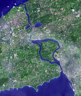
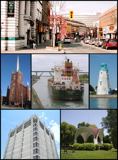
St. Catharines is the largest city in Canada's Niagara Region and the sixth largest urban area in the province of Ontario. As of 2016, it has an area of 96.13 square kilometres (37.12 sq mi), 133,113 residents, and a metropolitan population of 406,074. It lies in Southern Ontario, 51 kilometres (32 mi) south of Toronto across Lake Ontario, and is 19 kilometres (12 mi) inland from the international boundary with the United States along the Niagara River. It is the northern entrance of the Welland Canal. Residents of St. Catharines are known as St. Cathariners. St. Catharines carries the official nickname "The Garden City" due to its 1,000 acres (4 km2) of parks, gardens, and trails.
Welland is a city in the Regional Municipality of Niagara in Southern Ontario, Canada. In 2016, it had a population of 52,293.
Thorold is a city in Ontario, Canada, located on the Niagara Escarpment. It is also the seat of the Regional Municipality of Niagara.
The Welland Canal is a ship canal in Ontario, Canada, connecting Lake Ontario and Lake Erie. It forms a key section of the St. Lawrence Seaway and Great Lakes Waterway. Traversing the Niagara Peninsula from Port Weller in St. Catharines to Port Colborne, it enables ships to ascend and descend the Niagara Escarpment and bypass Niagara Falls. It is the fourth canal connecting these waterways; three smaller predecessors also bore the same name.
The Regional Municipality of Niagara, also colloquially known as the Niagara Region or Region of Niagara, is a regional municipality comprising twelve municipalities of Southern Ontario, Canada. The regional seat is in Thorold. It is the southern end of the Golden Horseshoe, the largest megalopolis in Canada.
King's Highway 58, commonly referred to as Highway 58, is a provincially maintained highway in the Canadian province of Ontario. The route is divided into two segments with a combined length of 15.5 km (9.6 mi). The southern segment travels from Niagara Regional Road 3, formerly Highway 3, in Port Colborne, to the Highway 58A junction in the southern end of Welland, a distance of 7.2 km (4.5 mi). The northern segment begins at Highway 20 near Allanburg and travels north and west to a large junction with Highway 406 at the St. Catharines – Thorold boundary, a distance of 8.3 km (5.2 mi). An 18.1 km (11.2 mi) gap separates the two segments within Welland and Pelham. The entire route is located within the Regional Municipality of Niagara.
Queenston is a compact rural community and unincorporated place 5 kilometres (3.1 mi) north of Niagara Falls in the Town of Niagara-on-the-Lake, Ontario, Canada. It is bordered by Highway 405 to the south and the Niagara River to the east; its location at the eponymous Queenston Heights on the Niagara Escarpment led to the establishment of the Queenston Quarry in the area. Across the river and the Canada–US border is the village of Lewiston, New York. The Lewiston-Queenston Bridge links the two communities. This village is at the point where the Niagara River began eroding the Niagara Escarpment. During the ensuing 12,000 years the Falls cut an 11 kilometres (6.8 mi) long gorge in the Escarpment southward to its present-day position.
Chippawa is a community located within the city of Niagara Falls, Ontario.
The Welland River is a river in the Golden Horseshoe that passes through the Southern Ontario cities of Welland and Niagara Falls. It flows from its source just south of Hamilton, Ontario to meet the Niagara River.
King's Highway 406, commonly referred to as Highway 406, is a 400-series highway in the Canadian province of Ontario. The primary north-south route through the central portion of the Niagara Peninsula, Highway 406 connects Welland, Thorold and downtown St. Catharines to the Queen Elizabeth Way (QEW).
Cooks Mills is a small community in the easternmost part of the city of Welland in Ontario, Canada. It was established, and is still centred, on a Welland River tributary called Lyons Creek. It is almost entirely a bedroom community, as there are few employers located in the area.
King's Highway 20, commonly referred to as Highway 20, is a provincially maintained highway in the Canadian province of Ontario. Presently, it is a short 1.9 km (1.2 mi) stub between Highway 58 and Niagara Regional Road 70 in the City of Thorold, but until 1997 it connected Hamilton to Niagara Falls, serving several towns atop the Niagara Escarpment en route.
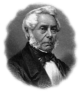
William Hamilton Merritt was a businessman and politician in the Niagara Peninsula of Upper Canada in the early 19th century. Although he was born in the United States, his family was Loyalist and eventually settled in Upper Canada. Merritt fought in the War of 1812, was captured by the invading American forces, and held as a prisoner of war. After the war, he returned to the Niagara region and began a career in business. He was one of the founders of the Welland Canal.
The Niagara Parkway, formerly known as Niagara Boulevard and historically as the Niagara Road, is a scenic road in the province of Ontario that travels on the Canadian side of the Niagara River from the town of Fort Erie to Niagara-on-the-Lake. The portion north of Table Rock in the city of Niagara Falls is designated as an Ontario Scenic Highway. Niagara Boulevard originally referred only to the section from Fort Erie to Chippawa.
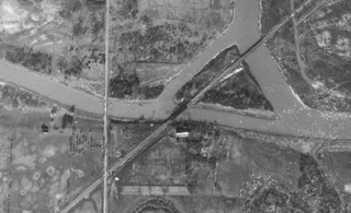
The Montrose Swing Bridge is located on the Welland River at the junction with the Queenston Power Canal in the southeast portion of the City of Niagara Falls, Ontario, Canada. It was built ca. 1910 to carry the Canada Southern Railway over the river. It is a two-track bridge, although only one track remains in use today. It crosses the river at roughly a 45-degree angle.
Twelve Mile Creek is a waterway located on the Niagara Peninsula in the Regional Municipality of Niagara in Southern Ontario, Canada. Its headwaters are located in the town of Pelham, encompassing some of the most unspoiled and natural areas of Niagara area. The creek's lower reaches flow through urban areas of Thorold and St. Catharines, and have been heavily altered by human activity for almost two centuries. The creek was first known as "Ashquasing" by the Mississaugas Indigenous people, the name meaning "that which lies at the end" in the Anishinaabe language.
John DeCew (1766–1855), was a United Empire Loyalist, an early settler in the Niagara Peninsula of Upper Canada, a commissioned militia officer in the War of 1812, and a founding member of the Welland Canal Company.
Lewis, William H. Aqueduct Merrittsville and Welland: a history of the city of Welland: the beginning years, A.M.W Publications, 1997. ISBN0-9682743-0-7.
This page is based on this Wikipedia article Text is available under the CC BY-SA 4.0 license; additional terms may apply. Images, videos and audio are available under their respective licenses.