The Yukon River is a major watercourse of northwestern North America. The river's source is in British Columbia, Canada, from which it flows through the Canadian Yukon Territory. The lower half of the river lies in the U.S. state of Alaska. The river is 3,190 kilometres (1,980 mi) long and empties into the Bering Sea at the Yukon–Kuskokwim Delta. The average flow is 6,430 m3/s (227,000 ft3/s). The total drainage area is 832,700 km2 (321,500 mi2), of which 323,800 km2 (126,300 mi2) is in Canada. The total area is more than 25% larger than Texas or Alberta.

Lake Austin, formerly Lake McDonald, is a water reservoir on the Colorado River in Austin, Texas. The reservoir was formed in 1939 by the construction of Tom Miller Dam by the Lower Colorado River Authority. Lake Austin is one of the seven Highland Lakes created by the LCRA, and is used for flood control, electrical power generation, and recreation.

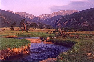
Rocky Mountain National Park is an American national park located approximately 76 mi (122 km) northwest of Denver International Airport in north-central Colorado, within the Front Range of the Rocky Mountains. The park is situated between the towns of Estes Park to the east and Grand Lake to the west. The eastern and westerns slopes of the Continental Divide run directly through the center of the park with the headwaters of the Colorado River located in the park's northwestern region. The main features of the park include mountains, alpine lakes and a wide variety of wildlife within various climates and environments, from wooded forests to mountain tundra.

The Thompson River is the largest tributary of the Fraser River, flowing through the south-central portion of British Columbia, Canada. The Thompson River has two main branches, the South Thompson River and the North Thompson River. The river is home to several varieties of Pacific salmon and trout. The area's geological history was heavily influenced by glaciation, and the several large glacial lakes have filled the river valley over the last 12,000 years. Archaeological evidence shows human habitation in the watershed dating back at least 8,300 years. The Thompson was named by Fraser River explorer, Simon Fraser, in honour of his friend, Columbia Basin explorer David Thompson. Recreational use of the river includes whitewater rafting and angling.

Middle Park is a high basin in the Rocky Mountains of north-central Colorado in the United States. It is located in Grand County, on the southwest slope of Rocky Mountain National Park, approximately 50 miles (80 km) west of Boulder.

Grand Lake is Colorado's largest and deepest natural lake. It is located in the headwaters of the Colorado River in Grand County, Colorado. On its north shore is located the historic and eponymous town of Grand Lake. The lake fills a glaciated valley that is dammed in part by glacial till from the Pinedale Glaciation, and is younger than about 12,000 years. Natural tributaries to the lake are the North Inlet and East Inlet, both of which flow out of Rocky Mountain National Park, which surrounds the lake on three sides: Grand Lake is located 1 mile from the Park's western entrance. Grand Lake was named Spirit Lake by the Ute Tribe because they believed the lake's cold waters to be the dwelling place of departed souls.

The Colorado-Big Thompson Project is a federal water diversion project in Colorado designed to collect West Slope mountain water from the headwaters of the Colorado River and divert it to Colorado's Front Range and plains. In Colorado, approximately 80% of the state's precipitation falls on the West Slope, in the Rocky Mountains, while around 80% of the state's growing population lives along the East Slope, between the cities of Fort Collins and Pueblo.

Granby Dam is an earthfill dam that dams the Colorado River 5.5 miles (8.9 km) northeast of Granby, Colorado in Grand County, Colorado. This 298-foot (91 m)-tall dam was constructed between 1941 and 1950 and has a drainage area of 311 square miles (810 km2). The Granby Dam's reservoir is known as Lake Granby, the largest reservoir component of the Colorado-Big Thompson Project. Lake Granby stores Colorado River water that is diverted under the Continental Divide for agriculture and municipal use within north-eastern Colorado including the cities of Boulder, Fort Collins, Loveland, and Greeley. In addition to the waters of the Colorado, water from Willow Creek just below the dam is pumped up 175 feet (53 m) to Lake Granby. Water from Lake Granby is pumped 125 feet (38 m) higher by the Granby Pumping Plant to the Granby Pump Canal, which extents 1.8 miles (2.9 km) to Shadow Mountain Lake, from which water is diverted through the Alva B. Adams Tunnel to the East Slope.

The Rio Chama, a major tributary river of the Rio Grande, is located in the U.S. states of Colorado and New Mexico. The river is about 130 miles (210 km) long altogether. From its source to El Vado Dam its length is about 50 miles (80 km), from El Vado Dam to Abiquiu Dam is about 51 miles (82 km), and from Abiquiu Dam to its confluence with the Rio Grande is about 34 miles (55 km).

The Mount Massive Wilderness is a federally designated wilderness area in the Sawatch Range, located in the U.S. state of Colorado. It is operated jointly by the United States Forest Service and the Fish and Wildlife Service as part of the San Isabel National Forest and the Leadville National Fish Hatchery. It is 30,540 acres (123.6 km2) in size, with 27,980 acres (113.2 km2) in San Isabel National Forest and 2,560 acres (10.4 km2) in Leadville National Fish Hatchery, and it was designated by the US Congress in 1980. The name comes from Mount Massive, the second highest peak in Colorado, located inside the wilderness. Elevations in the wilderness range from 9,700 feet (3,000 m) to 14,421 feet (4,396 m). It is the only federally designated wilderness area within the National Fish Hatchery System.

Wappinger Creek is a 41.7-mile-long (67.1 km) creek which runs from Thompson Pond to the Hudson River at New Hamburg in Dutchess County, New York, United States. It is the longest creek in Dutchess County, with the largest watershed in the county.
The Big Bend Gold Rush was a gold rush on the upper Columbia River in the Colony of British Columbia in the mid-1860s.

The Colorado Parks and Wildlife division of the U.S. State of Colorado manages more than 300 state wildlife areas with a total area of more than 860 square miles (2,230 km2) in the state. The Colorado state wildlife areas are managed for hunting, fishing, observation, management, and preservation of wildlife.