Five Blues Lake National Park

Last updated
Location of Five Blues Lake, (middle right). A diagram of Five Blues lake in Belize, showing its location.png
Location of Five Blues Lake, (middle right).

Five Blues Lake National Park is a 10-acre parcel of tropical forest in Belize, which is enclosed by over 4,000 acres of limestone hills. The lake obtained its name from the different shades of blue it reflects from the different water depths and the reflection of sunlight through the trees that frame the lake. The lake is maintained by an Association of Friends living in the Village of St. Margret's, a few minutes from the lakeside. Beside the lake is a shoreline of sunken limestone at the edge of the lake which leads to Orchid Island, where an abundance of wild orchids grows. In 2007, a drought was thought to have condemned the lake; studies were conducted to determine the cause.

Contents

History

Five Blues Lake was established as a national park in April 1991. Since the boundaries were not clearly defined, it was enlarged in April 1994, to approximately 1640 hectares, (4,000 acres). [1] Prior to the declaration the area was mainly exploited by people for fishing, hunting, and farming. Thereafter, the site was managed by a local Non-governmental Organization (NGO), called the Association of Friends of Five Blues Lake. The lake is believed to have formed because of a blockage of an underground waterway, which is a normal feature in karstic landscape. Various small streams also contributed to the creation of the lake.

Fauna

167 species of birds and over 20 species of bats have been identified in the park. [2] The five wild cats of Belize (jaguar, jaguarundi, margay, mountain lion and ocelot) are said to reside within the park, which is also home to howler monkeys, tapirs, pacas (gibnut), peccaries and armadillos. Studies have not been done on the aquatic life that exists in the lake; however, two species of fish have been found, bay snook and tuba.

St Margaret's Village Sign post to the community who manage the Five Blues National Park in Belize.png
St Margaret's Village

Five Blues lake is surrounded by deciduous forest and lime-living vegetation. Selective logging, chicle and rubber tapping, fruit gathering and other extractive uses, ancient Mayan silvicultural practices, and clearing for various types of agriculture have had considerable effects on the forest over time, but today the park is sustainably managed by the local community.

Physical features and climate

The lake is found in a karstic area with alluvial spots. The park also contains caves, sinkholes and exposed rock faces. The parcel contains calcareous soil, mainly shallow and stony, some drained clay areas, and riverine alluvium in the valleys, but most soil is limestone in origin. Steep hills surround the 7.4 acres (3.0 hectares) lake with seasonal swamp. The lake appears to be fed by small underground creeks. [3] It has a small island with an abundance of orchids. Five Blues hydrological structure is similar to that of Blue Hole National Park. The lake collects approximately 104 inches (260 cm) of rainfall annually. Its elevation is between 50 and 1,180 feet (15 and 360 m) above sea level. The park has water which flows over, under and through it which feeds into the Sibun River.

Drainage of lake

Unfortunately in 2006, the lake experienced a drought. Survey conducted determined that heavy rainfall in June and July 2006 led to flooding, which removed sediment fill or organic material in the caves. The average monthly rainfall at Hummingbird Villages totaled 432 millimetres (17.0 in) in June and 672 millimetres (26.5 in) in July 2006. The rapid drainage of the lake still remains uncertain. It is believed that it may have resulted from failure of a plug in the lake bed cenote that eased near-vertical discharge into underlying cave channels. Although prior reports of rapid drainage of cenote did not exist, heavy rainfall may have increased pressure in the lake, but there is no evidence of a lake-bottom plug either prior to drainage or as a result of sediment erosion before refilling, and the reported depth of the cenote, which puts it well below sea level, suggests that vertical drainage is unlikely. [4] Another cause could be that of an unblocking incident downstream, which led the water to drain out. This explanation is said to be more probable. Meerman [ who? ] reported that local residents had previously noted sudden fluctuations in the lake and that turbidity appeared to have become less seasonally predictable, perhaps presaging later developments. Furthermore, local residents reported that after the drainage of the lake there was a new, smaller lake in another part of the park which could point to an underground connection.

Local population

St. Margaret's (Santa Martha) Village is located on Hummingbird Highway and Lagoon Road at Mile 32. [5] The name St. Margaret's is now used to refer specifically to an area of government sub-divided land near Mile 32 that was set up about 5 years ago to accommodate a flood of Spanish-speaking immigrants. The village has mostly unsurveyed land, referred to as the older area of settlement. The village is said to be the refuge of many immigrants in the early 1980s. In 1980, the village had a population of 60 residents, in 1991 it increased to 415 and later to 600-700 people.

Related Research Articles

<span class="mw-page-title-main">Karst</span> Topography from dissolved soluble rocks

Karst is a topography formed from the dissolution of soluble carbonate rocks such as limestone, dolomite, and gypsum. It is characterized by features like poljes above and drainage systems with sinkholes and caves underground. More weathering-resistant rocks, such as quartzite, can also occur, given the right conditions.

<span class="mw-page-title-main">Sinkhole</span> Geologically-formed topological depression

A sinkhole is a depression or hole in the ground caused by some form of collapse of the surface layer. The term is sometimes used to refer to doline, enclosed depressions that are also known as shakeholes, and to openings where surface water enters into underground passages known as ponor, swallow hole or swallet. A cenote is a type of sinkhole that exposes groundwater underneath. Sink and stream sink are more general terms for sites that drain surface water, possibly by infiltration into sediment or crumbled rock.

<span class="mw-page-title-main">St. Herman's Blue Hole National Park</span>

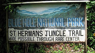
St. Herman's Blue Hole National Park is a national park located just off the Hummingbird Highway in Cayo District of Belize, near Belmopan, the capital city. It is over 500 acres (2 km²) in area, and contains two cave systems, various natural trails, and the cool jungle pool from which the park gets its name. The park is managed by the Belize Audubon Society.

<span class="mw-page-title-main">Cenote</span> Natural pit or sinkhole that exposes groundwater underneath

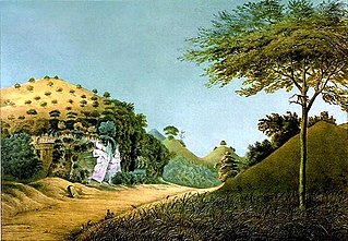
A cenote is a natural pit, or sinkhole, resulting when a collapse of limestone bedrock exposes groundwater. The term originated on the Yucatán Peninsula of Mexico, where the ancient Maya commonly used cenotes for water supplies, and occasionally for sacrificial offerings. The name derives from a word used by the lowland Yucatec Maya—tsʼonoʼot—to refer to any location with accessible groundwater.

<span class="mw-page-title-main">Yucatán Peninsula</span> Peninsula in North America

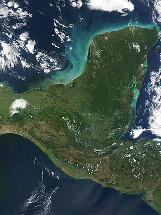
The Yucatán Peninsula is a large peninsula in southeast Mexico and adjacent portions of Belize and Guatemala. The peninsula extends towards the northeast, separating the Gulf of Mexico to the north and west of the peninsula from the Caribbean Sea to the east. The Yucatán Channel, between the northeastern corner of the peninsula and Cuba, connects the two bodies of water.

<span class="mw-page-title-main">Phong Nha – Kẻ Bàng National Park</span> UNESCO World Heritage Site in Vietnam

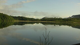
Phong Nha-Kẻ Bàng is a national park and UNESCO World Heritage Site in the Bố Trạch and Minh Hóa districts of central Quảng Bình Province in the North Central Coast region of Vietnam, about 500 km south of Hanoi. The park borders the Hin Namno National Park in Khammouane Province, Laos to the west and 42 km east of the South China Sea from its borderline point. Phong Nha-Kẻ Bàng National Park is in a limestone zone of 2,000 km2 in Vietnamese territory and borders another limestone zone of 2,000 km2 of Hin Namno in Laotian territory. The core zone of this national park covers 857.54 km2 and a buffer zone of 1,954 km2.

<span class="mw-page-title-main">Polje</span> Type of large plain found in karst regions

A polje, also called karst polje or karst field, is a large flat plain found in karstic geological regions of the world, with areas usually in the range of 5–400 km2 (2–154 sq mi). The name derives from the Slavic languages, where polje literally means 'field', whereas in English polje specifically refers to a karst plain or karst field.

<span class="mw-page-title-main">Domica Cave</span> Cave and archaeological site in Slovakia

The Domica cave is a karst cave situated on the south-western border of the Silicka planina Plateau 10 km (6.2 mi) south-east of Plesivec in the Rožňava District of the Košice Region in southern Slovakia. In combination with the Baradla cave, it makes up the most significant section of the Aggtelek Karst and Slovak Karst cross-border cave network that continues into the Aggtelek National Park in Hungary. The cave is well-known for its complex structure and high density of speleothems.

<span class="mw-page-title-main">Eramosa Karst</span> Karst in Stoney Creek, Ontario, Canada

The Eramosa Karst is a provincially significant Earth Science Area of Natural and Scientific Interest in Ontario, Canada, located in Stoney Creek, a constituent community of the City of Hamilton, and immediately south of the Niagara Escarpment.

Chiquibul National Park is Belize's largest national park. It is 1,073 km2 (414 sq mi) in size. The park is located in Belize's Cayo District. The national park surrounds Caracol, a Mayan city. Caracol has been designated as an archaeological reserve and is not included within the park's total area. Chiquibul Forest Reserve is adjacent to the park.

The Nambung River is a river in the Wheatbelt region of Western Australia, 170 kilometres (106 mi) north of Perth. The river drains an area between the towns of Cervantes and Badgingarra. In its lower reaches the Nambung River forms a chain of waterholes in the Nambung Wetlands where it disappears underground into a limestone karst system 5.5 kilometres (3 mi) from the Indian Ocean.

<span class="mw-page-title-main">Bắc Kạn province</span> Province of Vietnam

Bắc Kạn, sometimes misspelled Bắc Cạn, is a province of Vietnam. It is located in the Northeast region, due north of the capital Hanoi.

<span class="mw-page-title-main">Karst spring</span> Groundwater source in certain geological conditions

A karst spring or karstic spring is a spring that is part of a karst hydrological system.

Little Blue Lake is a water-filled sinkhole (“cenote”) in the Australian state of South Australia located in the state's south-east in the locality of Mount Schank about 20 kilometres (12 mi) south of the municipal seat of Mount Gambier. It is notable locally as a swimming hole and nationally as a cave diving site. It is managed by the District Council of Grant and has been developed as a recreational and tourism venue.

Tapir Mountain Nature Reserve is a protected area in Belize, Central America. It falls under category (Ia) of the International Union for Conservation of Nature protected areas categories. It is managed by the Belize Forest Department and co-managed by the Belize Karst Habitat Conservation.

<span class="mw-page-title-main">Cedar Sink</span> Landform in Edmonson County, Kentucky, United States

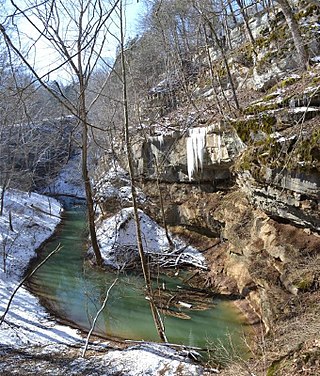
Cedar Sink is a vertical-walled large depression, or sinkhole, in the ground, that is located in Edmonson County, Kentucky and contained within and managed by Mammoth Cave National Park. The sinkhole measures 300 feet (91.4 m) from the top sandstone plateau to the bottom of the sink and was caused by collapse of the surface soil. The landscape is karst topography, which means the region is influenced by the dissolution of soluble rocks. Sinkholes, caves, and dolines typically characterize these underground drainage systems. Cedar Sink has a bottom area of about 7 acres (2.8 ha) and has more fertile soil compared to the ridgetops.

<span class="mw-page-title-main">Karst lake</span> Lakes formed as a result of the collapse of caves

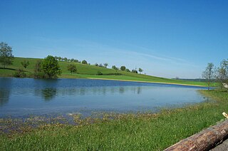
Karst lakes are formed as the result of a collapse of caves, especially in water-soluble rocks such as limestone, gypsum and dolomite. This process is known as karstification. They can cover areas of several hundred square kilometres. Their shallow lakebed is usually an insoluble layer of sediment so that water is impounded, leading to the formation of lakes. Many karst lakes only exist periodically, but return regularly after heavy rainfall.

<span class="mw-page-title-main">Gunung Sewu Geopark</span> Mountain range in Indonesia

Gunung Sewu Geopark or Sewu Mountains is a series of mountains stretching along the southern coast of Gunung Kidul Regency and Wonogiri Regency of Central Java, to Pacitan Regency of East Java in the island of Java, Indonesia. This is a national Geopark, which is also a member of Global Geopark Network (GGN), recognized by UNESCO in 2015.

<span class="mw-page-title-main">Nahá–Metzabok</span>

Nahá–Metzabok Biosphere Reserve is a biosphere reserve in southeastern Mexico. It is located in the state of Chiapas, on the northeastern flank of the Chiapas Highlands. The reserve protects montane rain forests, pine and oak forests, and natural lakes.

References

  1. "Five Blues Lake National Park". Belsize National Parks, Natural Reserves, & Wildlife Sanctuaries. Retrieved Dec 4, 2016.
  2. "Five Blues Lake National Park". Naturalight Productions Ltd, Stanncreek.com. Archived from the original on February 19, 2020. Retrieved Dec 4, 2016.
  3. http://biological-diversity.info/fiveblues.html%5B%5D
  4. Day, Mick; Reynolds, Bill (2012). "Five BluesLake National Park, Belize; A cautionary management tale" (PDF). Journal of Cave and Karst Studies. 74 (2). Journal of Cave and Karst Studies,v. 74, no. 2, p. 213–220: 213–220. doi: 10.4311/2011JCKS0203 . Retrieved Dec 4, 2016.
  5. "Belize Nature and National Park Guide". Guide to Belize.info. Dec 4, 2016. Retrieved Dec 4, 2016.

17°08′06″N88°34′48″W / 17.135°N 88.580°W / 17.135; -88.580