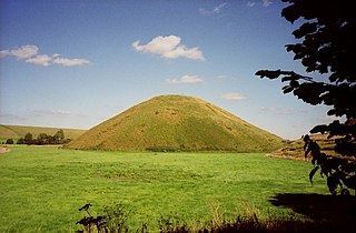
Silbury Hill is a prehistoric artificial chalk mound near Avebury in the English county of Wiltshire. It is part of the Stonehenge, Avebury and Associated Sites UNESCO World Heritage Site. At 39.3 metres (129 ft) high, it is the tallest prehistoric man-made mound in Europe and one of the largest in the world; similar in size to some of the smaller Egyptian pyramids of the Giza Necropolis.

Purbeck was a local government district in Dorset, England. The district was named after the Isle of Purbeck, a peninsula that forms a large proportion of the district's area. However, it extended significantly further north and west than the traditional boundary of the Isle of Purbeck which is the River Frome. The district council was based in the town of Wareham, which is itself north of the Frome.

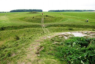
Arbor Low is a well-preserved Neolithic henge in the Derbyshire Peak District, England. It lies on a Carboniferous Limestone plateau known as the White Peak area. The monument consists of a stone circle surrounded by earthworks and a ditch.
Hambledon Hill is a prehistoric hill fort in Dorset, England, situated in the Blackmore Vale five miles northwest of Blandford Forum. The hill itself is a chalk outcrop, on the southwestern corner of Cranborne Chase, separated from the Dorset Downs by the River Stour. It is owned by the National Trust.

Chaldon Herring or East Chaldon is a village and civil parish in the English county of Dorset, about 8 miles (13 km) south-east of the county town of Dorchester. It is sited 2 miles (3.2 km) from the coast in the chalk hills of the South Dorset Downs. The highest point in the area is Chaldon Hill about 1.5 miles (2.4 km) to the south, overlooking the sea. In the 2011 census the civil parish had 59 households and a population of 140.

Lydlinch is a village and civil parish in the Blackmore Vale in north Dorset, England, about three miles west of Sturminster Newton. The village is sited on Oxford clay close to the small River Lydden. The parish – which includes the village of King's Stag to the south and the hamlet of Stock Gaylard to the west – is bounded by the Lydden to the east and its tributary, the Caundle Brook, to the north.

Winterborne Whitechurch, also Winterborne Whitchurch, is a village and civil parish in central Dorset, England, situated in a winterbourne valley on the A354 road on the Dorset Downs five miles southwest of Blandford Forum. In the 2011 census the civil parish had 354 dwellings, 331 households and a population of 757.

Bush Barrow is a site of the early British Bronze Age, at the western end of the Normanton Down Barrows cemetery. It is among the most important sites of the Stonehenge complex, having produced some of the most spectacular grave goods in Britain. It was excavated in 1808 by William Cunnington for Sir Richard Colt Hoare. The finds, including worked gold objects, are displayed at Wiltshire Museum in Devizes.
The Stonehenge Cursus is a large Neolithic cursus monument on Salisbury plain, near to Stonehenge in Wiltshire, England. It is roughly 3 kilometres (1.9 mi) long and between 100 metres (330 ft) and 150 metres (490 ft) wide. Excavations in 2007 dated the construction of the earthwork to between 3630 and 3375 BCE, several hundred years before the earliest phase of Stonehenge in 3000 BC. The cursus, along with adjacent barrows and the nearby 'Lesser Cursus' are part of the National Trust's Stonehenge Landscape property, and is within the Stonehenge and Avebury World Heritage Site.
Normanton Down is a Neolithic and Bronze Age barrow cemetery located about 0.6 miles (1 km) south of Stonehenge in Wiltshire, England. The burials date from between 2600 and 1600 BC and consist of a Neolithic long barrow and some 40 or more Bronze Age round barrows, sited along the crest of a low ridge.
The Cursus Barrows is the name given to a Neolithic and Bronze Age round barrow cemetery located mostly south of the western end of the Stonehenge Cursus. The cemetery contains around 18 round barrows scattered along an east-to-west ridge, although some of the mounds are no longer visible. The Cursus Barrows can be seen just north of the route between the Stonehenge Visitor Centre and Stonehenge.

Chaldon Hill, also called Chaldon Down, is one of the highest hills, 178 metres (584 ft), on South Dorset's Jurassic Coast in England. The summit is about 1.5 miles (2.4 km) west of Durdle Door.

The Grey Mare and her Colts is a megalithic chambered long barrow located near Abbotsbury in Dorset, England. It was built during the Early and Middle Neolithic periods. The tomb was partially excavated in the early nineteenth century, and was found to contain human bones and several pottery fragments.

Rempstone Stone Circle is a stone circle located near to Corfe Castle on the Isle of Purbeck in the south-western English county of Dorset. Archaeologists believe that it was likely erected during the Bronze Age. The Rempstone ring is part of a tradition of stone circle construction that spread throughout much of Britain, Ireland, and Brittany during the Late Neolithic and Early Bronze Age, over a period between 3,300 and 900 BCE. The purpose of such monuments is unknown, although archaeologists speculate that they were likely religious sites, with the stones perhaps having supernatural associations for those who built the circles. Local folklore holds that the stones arrived in their position after being thrown at Corfe Castle by the Devil.
Blackpatch is an archaeological site in West Sussex, England, about 2 miles (3.2 km) west of the village of Findon and about 3 miles (4.8 km) north-west of Worthing.

Wor Barrow is a Neolithic long barrow on Cranborne Chase, about 1 mile (1.6 km) east of Sixpenny Handley in Dorset, England. It is a scheduled monument.

The Thickthorn Down Long Barrows are two Neolithic long barrows, near the village of Gussage St Michael in Dorset, England. They are near the south-western end of the Dorset Cursus, a Neolithic feature. The long barrows are a scheduled monument.

Oakley Down Barrow Cemetery is a group of Bronze Age round barrows on Cranborne Chase, about 1 mile (1.6 km) east of the village of Sixpenny Handley in Dorset, England. It is a scheduled monument.

South Lodge Camp is an archaeological site of the Bronze Age, situated about 0.6 miles (1.0 km) south-east of the village of Tollard Royal, in Wiltshire, England. The site is on Cranborne Chase, near the boundary with Dorset. It is a scheduled monument.

