Five Points, Florida

Last updated

Five Points, Florida
CDP
FivePointsFL.png
Top, left to right: Five Points main intersection, Five Points sign, Five Points Elementary, Five Points Pawn, Pine Grove Baptist Church
Columbia County Florida Incorporated and Unincorporated areas Five Points Highlighted.svg
Location in Columbia County and the state of Florida
Coordinates: 30°12′55″N82°38′33″W / 30.21528°N 82.64250°W / 30.21528; -82.64250
Country Flag of the United States.svg  United States
State Flag of Florida.svg  Florida
County   Columbia
Area
[1]
  Total2.50 sq mi (6.46 km2)
  Land2.49 sq mi (6.46 km2)
  Water0.00 sq mi (0.00 km2)
Elevation
[2]
167 ft (51 m)
Population
 (2020)
  Total1,076
  Density431.44/sq mi (166.59/km2)
Time zone UTC-5 (Eastern (EST))
  Summer (DST) UTC-4 (EDT)
ZIP code
32055 [3]
Area code 386
FIPS code 12-22475 [4]
GNIS feature ID0282521 [2]

Five Points is a census-designated place (CDP) in Columbia County, Florida, United States. The population was 1,076 at the 2020 census, down from 1,265 at the 2010 census. It is part of the Lake City, Florida Micropolitan Statistical Area.

Contents

Geography

Five Points is located at 30°12′55″N82°38′33″W / 30.215348°N 82.642558°W / 30.215348; -82.642558 . [5]

According to the United States Census Bureau, the CDP has a total area of 2.6 square miles (6.7 km2), all land.

Demographics

Historical population
CensusPop.Note
1990 1,136
2000 1,36219.9%
2010 1,265−7.1%
2020 1,076−14.9%
U.S. Decennial Census [6]

As of the census [4] of 2000, there were 1,362 people, 417 households, and 266 families residing in the CDP. The population density was 527.6 inhabitants per square mile (203.7/km2). There were 480 housing units at an average density of 185.9 per square mile (71.8/km2). The racial makeup of the CDP was 82.75% White, 15.71% Black, 0.22% American Indian, 0.22% Asian, 0.22% from other races, and 0.88% from two or more races. Hispanic or Latino of any race were 1.91% of the population.

There were 417 households, out of which 30.5% had children under the age of 18 living with them, 36.9% were married couples living together, 22.1% had a female householder with no husband present, and 36.2% were non-families. 28.1% of all households were made up of individuals, and 9.8% had someone living alone who was 65 years of age or older. The average household size was 2.56 and the average family size was 3.11.

In the CDP, the population was spread out, with 23.1% under the age of 18, 13.5% from 18 to 24, 36.1% from 25 to 44, 18.8% from 45 to 64, and 8.4% who were 65 years of age or older. The median age was 32 years. For every 100 females, there were 138.1 males. For every 100 females aged 18 and over, there were 141.8 males.

The median income for a household in the CDP was $15,057, and the median income for a family was $15,375. Males had a median income of $17,446 versus $11,964 for females. The per capita income for the CDP was $6,246. About 30.7% of families and 43.8% of the population were below the poverty line, including 67.6% of those under age 18 and 8.8% of those aged 65 or over.

Related Research Articles

Upper Grand Lagoon is a census-designated place (CDP) in Bay County, Florida, United States. The population was 15,778 at the 2020 census, up from 13,963 at the 2010 census. It is part of the Panama City–Panama City Beach, Florida Metropolitan Statistical Area.

<span class="mw-page-title-main">Watertown, Florida</span> CDP in Florida, United States

Watertown is a census-designated place (CDP) in Columbia County, Florida, United States. It had a population of 3,018 at the 2020 census, up from 2,829 at the 2010 census. It is part of the Lake City, Florida Micropolitan Statistical Area.

<span class="mw-page-title-main">Lake Lindsey, Florida</span> Census-designated place in Florida, United States

Lake Lindsey is an unincorporated community and census-designated place (CDP) in Hernando County, Florida, United States. The population was 71 at the 2010 census.

<span class="mw-page-title-main">North Brooksville, Florida</span> Census-designated place in Florida, United States

North Brooksville is a census-designated place (CDP) in Hernando County, Florida, United States. The population was 3,544 at the 2010 census. It is a suburb included in the Tampa-St. Petersburg-Clearwater, Florida Metropolitan Statistical Area.

<span class="mw-page-title-main">South Brooksville, Florida</span> Census-designated place in Florida, United States

South Brooksville is a census-designated place (CDP) in Hernando County, Florida, United States. The population was 4,007 at the 2010 census. It is a suburb included in the Tampa-St. Petersburg-Clearwater, Florida Metropolitan Statistical Area.

<span class="mw-page-title-main">Cheval, Florida</span> Census-designated place in Florida, United States

Cheval is a census-designated place in Hillsborough County, Florida, United States. The population was 10,702 at the 2010 census, up from 7,602 at the 2000 census.

<span class="mw-page-title-main">Mango, Florida</span> Census-designated place in Florida, United States

Mango is a census-designated place (CDP) in Hillsborough County, Florida, United States. The population was 12,699 at 2020 census, up from the 11,313 at the 2010 census.

<span class="mw-page-title-main">Pebble Creek, Florida</span> Census-designated place in Florida, United States

Pebble Creek is a census-designated place (CDP) in Hillsborough County, Florida, United States. The population was 9,624 at the 2020 census, up from 7,622 at the 2010 census. Pebble Creek is located in the unincorporated portion of New Tampa, and is primarily a residential zone.

<span class="mw-page-title-main">Naranja, Florida</span> Census-designated place in Florida

Naranja is an unincorporated community and census-designated place (CDP) in Miami-Dade County, Florida, United States. Many orange groves were once located in this area, so the community name came from the Spanish word for orange, naranja, though the pronunciation among the local residents is "Na-Ran-Jah". Naranja was also a stop for the Florida East Coast Railroad that once ran through this area. It is part of the Miami metropolitan area of South Florida. The population was 13,509 at the 2020 census, up from 8,303 in 2010.

<span class="mw-page-title-main">Palmetto Estates, Florida</span> Census-designated place in Florida

Palmetto Estates is an unincorporated area and census-designated place (CDP) in Miami-Dade County, Florida, United States. It is part of the Miami metropolitan area of South Florida. The population was 13,498 at the 2020 census.

<span class="mw-page-title-main">Fairview Shores, Florida</span> Census-designated place in Florida, United States

Fairview Shores is a census-designated place and an unincorporated area in Orange County, Florida, United States. The population was 10,239 at the 2010 census. It is part of the Orlando–Kissimmee–Sanford, Florida Metropolitan Statistical Area.

<span class="mw-page-title-main">Southchase, Florida</span> Census-designated place in Florida, United States

Southchase is a census-designated place and an unincorporated area in Orange County, Florida, United States. The population was 15,921 at the 2010 census. It is part of the Orlando–Kissimmee–Sanford, Florida Metropolitan Statistical Area.

<span class="mw-page-title-main">Crystal Springs, Florida</span> CDP in Florida, United States

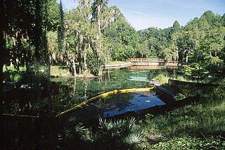
Crystal Springs is a hydrological spring and a census-designated place (CDP) in Pasco County, Florida, United States. The population was 1,175 at the 2000 census.

<span class="mw-page-title-main">Dade City North, Florida</span> CDP in Florida, United States

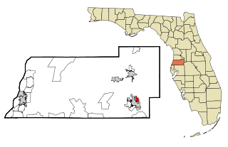
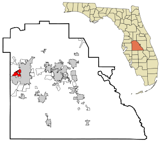
Dade City North is a census-designated place (CDP) in eastern Pasco County, Florida, United States. The population was 3,319 at the 2000 census.

<span class="mw-page-title-main">Lacoochee, Florida</span> CDP in Florida, United States

Lacoochee is a census-designated place (CDP) in Pasco County, Florida, United States. The population was 1,345 at the 2000 census.

<span class="mw-page-title-main">Zephyrhills North, Florida</span> CDP in Florida, United States

Zephyrhills North is a census-designated place (CDP) in Pasco County, Florida, United States. The population was 2,544 at the 2000 census.

<span class="mw-page-title-main">Zephyrhills South, Florida</span> CDP in Florida, United States

Zephyrhills South is a census-designated place (CDP) in Pasco County, Florida, United States. The population was 4,435 at the 2000 census.

<span class="mw-page-title-main">Winston, Florida</span> Place in Florida, United States

Winston is a former census-designated place (CDP) in Polk County, Florida, United States. The population was 9,024 at the 2000 census. Most of the community's core is now part of neighboring Lakeland. It is part of the Lakeland–Winter Haven Metropolitan Statistical Area.

<span class="mw-page-title-main">North Sarasota, Florida</span> Census-designated place in Florida, United States

North Sarasota is a census-designated place (CDP) in Sarasota County, Florida, United States. The population was 2,418 at the 2020 census, down from 6,982 at the 2010 census. It is part of the North Port–Bradenton–Sarasota, Florida Metropolitan Statistical Area.

<span class="mw-page-title-main">Carrollwood (CDP), Florida</span> Census-designated place in Florida, United States

Carrollwood is a census-designated place (CDP) in northwestern Hillsborough County, Florida, United States. The census area includes the unincorporated communities of Carrollwood and Carrollwood Village. For the 2000 census the area was enumerated under the name "Greater Carrollwood". A similar area was listed as "Lake Carroll" in 1970 and 1980; for the 1990 census it was split into the smaller Carrollwood and Carrollwood Village CDPs. The population was 34,352 at the 2020 census.

References

  1. "2020 U.S. Gazetteer Files". United States Census Bureau. Retrieved October 31, 2021.
  2. 1 2 U.S. Geological Survey Geographic Names Information System: Five Points, Florida
  3. "Five Points FL ZIP Code". zipdatamaps.com. 2023. Retrieved February 17, 2023.
  4. 1 2 "U.S. Census website". United States Census Bureau . Retrieved January 31, 2008.
  5. "US Gazetteer files: 2010, 2000, and 1990". United States Census Bureau. February 12, 2011. Retrieved April 23, 2011.
  6. "Census of Population and Housing". Census.gov. Retrieved June 4, 2016.