Montcalm County is a county in the U.S. state of Michigan. As of the 2020 Census, the population was 66,614. The county is geographically located in the West Michigan region of the Lower Peninsula. The county seat is Stanton, and the largest city is Greenville. The county is named for General Marquis Louis-Joseph de Montcalm, military commander of French troops during the French and Indian War. The county was set off in 1831 and organized in 1850.

Kent County is located in the U.S. state of Michigan. As of the 2020 Census, the county had a population of 657,974, making it the fourth most populous county in Michigan, and the largest outside of the Detroit area. Its county seat is Grand Rapids. The county was set off in 1831, and organized in 1836. It is named for New York jurist and legal scholar James Kent, who represented the Michigan Territory in its dispute with Ohio over the Toledo Strip.

Ionia County is a county located in the U.S. state of Michigan. As of the 2020 census, the population was 66,804. The county seat is Ionia. The Ionia County Courthouse was designed by Claire Allen, a prominent southern Michigan architect.

Ada Township is a civil township of Kent County in the U.S. state of Michigan. The population was 14,388 at the 2020 census.

Grattan Township is a civil township of Kent County in the U.S. state of Michigan. As of the 2010 census, the township population was 3,621.

Vergennes Township is a civil township of Kent County in the U.S. state of Michigan. As of the 2010 census, the township population was 4,189.
Belvidere Township is a civil township of Montcalm County in the U.S. state of Michigan. As of the 2020 census, the township population was 2,135.
Eureka Township is a charter township of Montcalm County in the U.S. state of Michigan. The population was 4,211 at the 2020 census, up from 3,959 in 2010.

Greenville is a city in the Lower Peninsula of the U.S. state of Michigan. With a population 8,816 at the 2020 census, it is the largest city in Montcalm County. The city is the location of the establishment of the Meijer chain of stores.

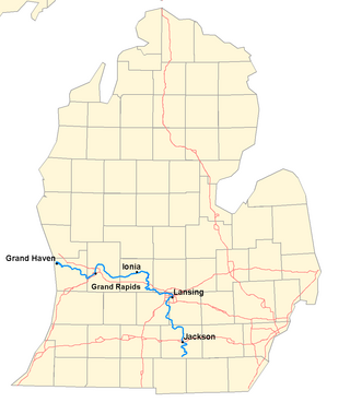
The Grand River is a 252-mile-long (406 km) river in the Lower Peninsula of the U.S. state of Michigan. The longest river in Michigan, the Grand River rises in Hillsdale County, and flows in a generally northwesterly direction to its mouth at Lake Michigan in the city of Grand Haven. The river flows through a number of cities, including Jackson, Lansing, Ionia, and Grand Rapids.

M-21 is an east–west state trunkline highway in the US state of Michigan connecting the cities of Grand Rapids and Flint. The highway passes through rural farming country and several small towns along its course through the Lower Peninsula. Following the course of a handful of rivers, M-21 also connects some of the state's freeways like Interstate 96 (I-96), US Highway 127 (US 127) and I-75. The highway is used by between 1,700 and 36,000 vehicles daily.

M-91 is a largely north–south state trunkline highway in the Lower Peninsula of the US state of Michigan. It runs from Belding to south of Lakeview. Its 24-mile (39 km) length exists entirely within Ionia and Montcalm counties. It is all undivided surface route. Aside from the two Michigan state highways that are its termini, it has only one other intersection with any Michigan state highway, and that is with M-57 in Greenville.

M-44 is a 37.463-mile (60.291 km) state trunkline highway in the western region of the US state of Michigan. It runs northward from the intersection of M-11 and M-37 toward the Rockford area. The highway then turns eastward to Belding, and it ends six miles (10 km) north of Ionia at M-66. M-44 is known in Grand Rapids as the "East Beltline" and intersects with its related highway, Connector M-44, in Plainfield Township. This highway runs concurrently with M-37 between M-11 and Interstate 96 (I-96).

The Thornapple River is an 88.1-mile-long (141.8 km) tributary of Michigan's longest river, the Grand River. The Thornapple rises in Eaton County, Michigan and drains a primarily rural farming area in Central Michigan. It joins the Grand in Ada, Michigan, 10 miles (16 km) east of Grand Rapids.

Fallasburg Bridge is a 100-foot (30 m) span Brown truss covered bridge, erected in 1871 in Vergennes Township, Michigan, United States, 5 miles (8.0 km) north of Lowell on the Flat River. Carrying Covered Bridge Road across the Flat, it is located in the Fallasburg Historical District south of Whites Bridge and Smyrna. It is listed on the National Register of Historic Places, and along with Whites Bridge, Langley Covered Bridge, and Zehnder's Holz Brucke, is one of only four Michigan covered bridges open to vehicle traffic.

The Coldwater River is a 19.4-mile-long (31.2 km) stream in the U.S. state of Michigan. Located in western Michigan, the river is a part of the Grand River drainage basin.
The Patterson Railroad is a defunct railroad that existed in Michigan during the early 1870s. The company incorporated on September 21, 1870 and filed articles on October 3 to construct a line between Patterson Mills and Kiddville. The Patterson completed a 1.67-mile (2.69 km) in July 1872, at which point the property became part of the Detroit, Lansing and Lake Michigan Railroad, whose line it met at Kiddville. The DL&M would later become part of the Pere Marquette Railroad, which also built a line south from Belding.
The Ionia and Lansing Rail Road is a defunct railroad which operated in the state of Michigan in the 1860s and 1870s. The company incorporated on November 13, 1865; the investors hailed primarily from Lansing, Ionia and Portland. The original charter called for a 34-mile (55 km) line from Ionia to Lansing; on January 13, 1869 this was amended with a much grander vision: a 125-mile (201 km) line from Lansing to the mouth of the Pentwater River at Pentwater, on the shores of Lake Michigan.
The Grand Rapids, Belding and Saginaw Railroad is a defunct railroad which operated in the state of Michigan at the turn of the 20th century.


