
The Marine Mill, established in 1839, was the first commercial sawmill in what became the U.S. state of Minnesota. Now in ruins, it is currently a historic site managed by the city of Marine on St. Croix in partnership with the Minnesota Historical Society. It was listed on the National Register of Historic Places as the Marine Mill Site in 1970 for having state-level significance in the themes of exploration/settlement, industry, and transportation. It was nominated for being the birthplace of the region's seminal industry—lumbering—and a major landing on its crucial transportation route, the St. Croix River. The site is also a contributing property to the Marine on St. Croix Historic District.

This is a list of the National Register of Historic Places listings in Stearns County, Minnesota. It is intended to be a complete list of the properties and districts on the National Register of Historic Places in Stearns County, Minnesota, United States. The locations of National Register properties and districts for which the latitude and longitude coordinates are included below, may be seen in an online map.
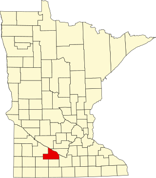
This is a list of the National Register of Historic Places listings in Brown County, Minnesota. It is intended to be a complete list of the properties and districts on the National Register of Historic Places in Brown County, Minnesota, United States. The locations of National Register properties and districts for which the latitude and longitude coordinates are included below, may be seen in an online map.

This is a list of the National Register of Historic Places listings in Morrison County, Minnesota. It is intended to be a complete list of the properties and districts on the National Register of Historic Places in Morrison County, Minnesota, United States. The locations of National Register properties and districts for which the latitude and longitude coordinates are included below, may be seen in an online map.

This is a list of the National Register of Historic Places listings in Fillmore County, Minnesota. It is intended to be a complete list of the properties and districts on the National Register of Historic Places in Fillmore County, Minnesota, United States. The locations of National Register properties and districts for which the latitude and longitude coordinates are included below, may be seen in an online map.

This is a list of the National Register of Historic Places listings in Itasca County, Minnesota. It is intended to be a complete list of the properties and districts on the National Register of Historic Places in Itasca County, Minnesota, United States. The locations of National Register properties and districts for which the latitude and longitude coordinates are included below, may be seen in an online map.

This is a list of the National Register of Historic Places listings in Le Sueur County, Minnesota. It is intended to be a complete list of the properties and districts on the National Register of Historic Places in Le Sueur County, Minnesota, United States. The locations of National Register properties and districts for which the latitude and longitude coordinates are included below, may be seen in an online map.

This is a list of the National Register of Historic Places listings in Wabasha County, Minnesota. It is intended to be a complete list of the properties and districts on the National Register of Historic Places in Wabasha County, Minnesota, United States. The locations of National Register properties and districts for which the latitude and longitude coordinates are included below, may be seen in an online map.

This is a list of the National Register of Historic Places listings in Washington County, Minnesota. It is intended to be a complete list of the properties and districts on the National Register of Historic Places in Washington County, Minnesota, United States. The locations of National Register properties and districts for which the latitude and longitude coordinates are included below, may be seen in an online map.

This is a list of the National Register of Historic Places listings in Rock County, Minnesota. It is intended to be a complete list of the properties and districts on the National Register of Historic Places in Rock County, Minnesota, United States. The locations of National Register properties and districts for which the latitude and longitude coordinates are included below, may be seen in an online map.

This is a list of the properties and districts on the National Register of Historic Places in Cook County, Minnesota, United States. The locations of National Register properties and districts for which the latitude and longitude coordinates are included below, may be seen in an online map.
This is a list of the National Register of Historic Places listings in Houston County, Minnesota. It is intended to be a complete list of the properties and districts on the National Register of Historic Places in Houston County, Minnesota, United States. The locations of National Register properties and districts for which the latitude and longitude coordinates are included below, may be seen in an online map.

This is a list of the National Register of Historic Places listings in Faribault County, Minnesota. This is intended to be a complete list of the properties and districts on the National Register of Historic Places in Faribault County, Minnesota, United States. The locations of National Register properties and districts for which the latitude and longitude coordinates are included below, may be seen in an online map.

This is a list of the National Register of Historic Places listings in Kandiyohi County, Minnesota. It is intended to be a complete list of the properties and districts on the National Register of Historic Places in Kandiyohi County, Minnesota, United States. The locations of National Register properties and districts for which the latitude and longitude coordinates are included below, may be seen in an online map.

The Kettle Falls Historic District encompasses a remote pocket of early-20th-century industrial and commercial activity deep in the Boundary Waters, in what is now Voyageurs National Park in the U.S. state of Minnesota. Kettle Falls is the outlet from Namakan Lake into Rainy Lake on the Canada–United States border. The portage between the two lakes served as a key gathering point from the time of the voyageurs to the miners, commercial fishermen, and lumbermen at the turn of the 20th century, and tourists beginning in the 1930s. The Kettle Falls Dam was built at the site between 1910 and 1914, and two log buildings associated with its construction remain standing. The fourth contributing property to the historic district is the Kettle Falls Hotel, built in 1913.
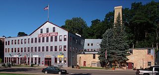
Isaac Staples' Sawmill is a historic industrial property in Stillwater, Minnesota, United States, consisting of an 1850 stone powerhouse and a 1900 metal-clad factory. The property was listed on the National Register of Historic Places as St. Croix Lumber Mills—Stillwater Manufacturing Company in 1982 for its local significance in the theme of industry. It was nominated because the powerhouse is the only surviving industrial building associated with Isaac Staples (1816–1898), a major figure in Minnesota's early commercial development. The property now operates as a shopping mall with upper level apartments.

The East Second Street Commercial Historic District is a small historic district in Winona, Minnesota, United States. It comprises 14 contributing properties mostly built in the late 1860s. The district was listed on the National Register of Historic Places in 1991 for its state-level significance in the themes of architecture and commerce. It was nominated for being one of the few surviving remnants of the original business district of a Minnesota river town, and for being a symbol of Winona's swift growth as a lumber and grain trade center.
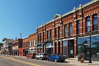
The Stillwater Commercial Historic District encompasses 11 downtown blocks in Stillwater, Minnesota, United States. It comprises 63 contributing properties built from the 1860s to 1940. It was listed as a historic district on the National Register of Historic Places in 1992 for its local significance in the themes of architecture and commerce. It was nominated for reflecting the economic and architectural diversity of a prosperous lumbering and manufacturing center.
The Mike and Mary Matson Farmstead is a historic farmstead in Embarrass Township, Minnesota, United States. It was established by a Finnish immigrant family around 1900 and includes five surviving buildings constructed with traditional Finnish log architecture. The farm was listed as a historic district on the National Register of Historic Places in 1990 for its state-level significance in the themes of agriculture, architecture, and European ethnic heritage. It was nominated for its association with the Finnish settlement and conversion of St. Louis County's cutover woodland into productive farmland, and for exhibiting their use of traditional log architecture.
The Matt and Emma Hill Farmstead is a historic farmstead in Pike Township, Minnesota, United States. It was established in 1897 by one of many Finnish Americans who left employment in Iron Range mines to begin farming northern Minnesota's cutover forests. The farm was listed as a historic district on the National Register of Historic Places in 1990 for its state-level significance in the themes of agriculture, architecture, and European ethnic heritage. It was nominated for reflecting the pivot of St. Louis County's Finnish immigrants from industrial labor to agriculture, and their use of traditional log architecture.


