Related Research Articles

Flitwick is a town and civil parish in Bedfordshire, England. It is mentioned in the Domesday Book of 1086 as "a hamlet on the River Flitt". The spelling Flytwyk appears in 1381.

Studham is a village and civil parish in the county of Bedfordshire. It has a population of 1,128. The parish bounds to the south of the Buckinghamshire border, and to the east is the Hertfordshire border. The village lies in the wooded south facing dip slope of the Chiltern Hills. The hamlet of Holywell is located to the north of Studham, and forms part of the same civil parish.

Mid Bedfordshire is a constituency represented in the House of Commons of the UK Parliament since 2005 by Nadine Dorries, of the Conservative Party. Apart from four early years, the constituency has returned a Conservative since its creation in 1918.

Barton-le-Clay is a large village and a civil parish in the Central Bedfordshire Borough in Bedfordshire, England, bordering Hertfordshire. The village has existed since at least 1066 and is mentioned in the Domesday Book.

Blunham is a village and civil parish in the Central Bedfordshire district of Bedfordshire, England, about 8 miles (13 km) east of Bedford. At the 2011 census date its population was 946. The River Ivel forms the parish's eastern boundary in places and the River Great Ouse its western and northern boundaries. The village is just over 0.6 miles (1 km) to the west of the A1 road, and Route 51 of the National Cycle Network passes to the south.

The River Flit is a short river in Bedfordshire, England. Its name is not ancient, but rather a back formation from Flitton which originally meant that the river was spelt with as Flitt rather than Flit.

Ampthill was a rural district in Bedfordshire, England from 1894 to 1974. It entirely surrounded but did not include the urban district of Ampthill.
Greenfield is a small village about 2 km (1.2 mi) from the town of Flitwick in Bedfordshire, England. It lies across Flitwick Moor from the larger settlement of Flitwick and is on the opposite side of the River Flit. It forms part of the parish of Flitton and Greenfield.

Silsoe is a village and civil parish in Bedfordshire, England. The village used to be on the main A6 road but a bypass around the village was opened in 1981 at a cost of £1.6m.
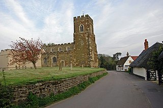
Flitton is a small village in Bedfordshire, England, which forms part of the parish of Flitton and Greenfield. The village derives its name from the River Flit which flows close by it. It is notable primarily as the home of the De Grey Mausoleum adjacent to the St John the Baptist Church. Richard Milward, the editor of Selden's Table Talk, was born at Flitton in 1609. There are two pubs, The White Hart by the church hall and Jolly Coopers at Wardhedges. The annual ‘Gala’ and ‘Potato Race’ are two of the main events that happen in the village.

The de Grey Mausoleum in Flitton, Bedfordshire, England, is one of the largest sepulchral chapels in the country. The Mausoleum contains over twenty monuments to the de Grey family who lived in nearby Wrest Park.
Hyde is a civil parish in the county of Bedfordshire. It lies just south-east of Luton.

Clophill is a village and civil parish clustered on the north bank of the River Flit, Bedfordshire, England. It is recorded in the Domesday Book of 1086 as Clopelle. "Clop" likely means 'tree-stump' in Old English. However, it also has cognate terms for clay, with which the soil of mid Bedfordshire is rich.

Central Bedfordshire is a unitary authority area in the ceremonial county of Bedfordshire, England. It was created in 2009.

Gravenhurst is a village and civil parish located in the Central Bedfordshire district of Bedfordshire, England.

Kensworth is a village and civil parish located in the Central Bedfordshire district of Bedfordshire, England. The parish is located on the edge of Dunstable Downs, and includes the hamlets of California and Kensworth Lynch.

Stondon is a civil parish located in the Central Bedfordshire district of Bedfordshire, England. The parish includes the settlements of Lower Stondon and Upper Stondon.
Elections to Central Bedfordshire Council were held on 7 May 2015, along with the 2015 United Kingdom general election and other local elections. The whole council was up for election, with each successful candidate serving a four-year term of office, expiring in 2019.
References
- ↑ "Civil Parish population 2011". Neighbourhood Statistics. Office for National Statistics. Retrieved 7 November 2016.
| | This Bedfordshire location article is a stub. You can help Wikipedia by expanding it. |