
Dr Johnson's House is a writer's house museum in London in the former home of the 18th-century English writer and lexicographer Samuel Johnson. The house is a Grade I listed building.
9 Downing Street is one of the buildings situated on Downing Street in the City of Westminster in London, England. It has been used as a separate address to the better known 10 Downing Street since 2001 for various government functions.

St Olave's Church, Old Jewry, sometimes known as Upwell Old Jewry, was a church in the City of London located between the street called Old Jewry and Ironmonger Lane. Destroyed in the Great Fire of London in 1666, the church was rebuilt by the office of Sir Christopher Wren. The church was demolished in 1887, except for the tower and west wall, which remain today.

Tite Street is a street in Chelsea, London, England, within the Royal Borough of Kensington and Chelsea, just north of the River Thames. It was laid out from 1877 by the Metropolitan Board of Works, giving access to the Chelsea Embankment.

Piccadilly Arcade runs between Piccadilly and Jermyn Street in central London. It was opened in 1909, having been designed by Thrale Jell, and is a Grade II listed building.

Lowndes Square is a residential garden square at the north-west end of Belgravia, London, SW1. It is formed of archetypal grand terraces of light stucco houses, cream or white. The length of the central rectangular garden is parallel with Sloane Street to the west; visible from the north-west corner is a corner of the Harvey Nichols store, beyond which is Knightsbridge tube station. Ecclesiastically, it remains in a northern projection of one of the parishes of Chelsea, except its east side, which is in the very small parish of St Paul, Knightsbridge, a division which is mirrored secularly by the boundaries of two London Boroughs.
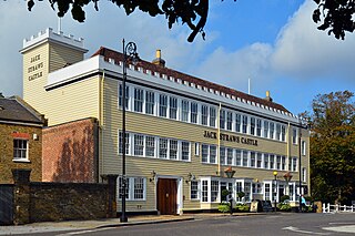
Jack Straw's Castle is a Grade II listed building and former public house on North End Way, Hampstead, north-west London, England close to the junction with Heath Street and Spaniards Road.

Rathbone Place is a street in central London that runs roughly north-west from Oxford Street to Percy Street. it is joined on its eastern side by Percy Mews, Gresse Street, and Evelyn Yard. The street is mainly occupied by retail and office premises.

Chenies Street is a street in Bloomsbury, London, that runs between Tottenham Court Road and Gower Street. It is the location of a number of notable buildings such as Minerva House, the Drill Hall, and a memorial to The Rangers, 12th County of London Regiment. North Crescent starts and ends on the northern side of Chenies Street.

Bolton Street is a street in Mayfair London, between Curzon Street to its north, and Piccadilly to its south. It is named after the Duke of Bolton, and was from its construction during the 17th century and 1708 the westernmost street of London.

The Cheshire Cheese is a public house at 5 Little Essex Street, London WC2, on the corner with Milford Lane.

South Audley Street is a major shopping street in Mayfair, London. It runs north to south from the southwest corner of Grosvenor Square to Curzon Street.

John Samuel PheneFRGS, FSA, FRIBA was a British architect, who lived in Chelsea, London, for more than 50 years.
Grenville Place is a street in the Royal Borough of Kensington and Chelsea, London, that connects Cornwall Gardens and Launceston Place in the north with Cromwell Road in the south. It is crossed in its northern part by Cornwall Mews South, and joined on its western side by Emperor's Gate (twice). it is joined on its eastern side by Southwell Gardens.
King Edward Street is a street in the City of London that runs from Newgate Street in the south to Little Britain in the north. It is joined by Greyfriars Passage in the west and Angel Street in the east. Postman's Park is on its east side where Bull and Mouth Street once lay and joined King Edward Street.

Oakley Street is in the Royal Borough of Kensington and Chelsea, London. It runs roughly north to south from King's Road to the crossroads with Cheyne Walk and the River Thames, where it continues as the Albert Bridge and Albert Bridge Road. The street was named after Baron Cadogan of Oakley.

Chepstow Place is a street in London that runs from the junction of Westbourne Grove and Pembridge Villas in the north to Pembridge Square in the south. It is crossed by Dawson Place and joined on its eastern side by Rede Place. The east side is in the City of Westminster and the west side in the Royal Borough of Kensington and Chelsea.

The Green Man is a Grade II listed public house at 57 Berwick Street, in London's Soho.

Old Change was a street in the City of London, connecting Cheapside to Knightrider Street.

Norfolk Square is a rectangular garden square in Paddington in Central London. Located in the City of Westminster, it is part of the Tyburnia district north of Hyde Park. It runs east to west from London Street to Norfolk Place. Praed Street and Sussex Gardens are directly parallel to it north and south respectively.

