
A dam is a barrier that stops or restricts the flow of water or underground streams. Reservoirs created by dams not only suppress floods but also provide water for activities such as irrigation, human consumption, industrial use, aquaculture, and navigability. Hydropower is often used in conjunction with dams to generate electricity. A dam can also be used to collect water or for storage of water which can be evenly distributed between locations. Dams generally serve the primary purpose of retaining water, while other structures such as floodgates or levees are used to manage or prevent water flow into specific land regions. The earliest known dam is the Jawa Dam in Jordan, dating to 3,000 BC.

The River Welland is a lowland river in the east of England, some 65 miles (105 km) long. It drains part of the Midlands eastwards to The Wash. The river rises in the Hothorpe Hills, at Sibbertoft in Northamptonshire, then flows generally northeast to Market Harborough, Stamford and Spalding, to reach The Wash near Fosdyke. It is a major waterway across the part of the Fens called South Holland, and is one of the Fenland rivers which were laid out with washlands. There are two channels between widely spaced embankments with the intention that flood waters would have space in which to spread while the tide in the estuary prevented free egress. However, after the floods of 1947, new works such as the Coronation Channel were constructed to control flooding in Spalding and the washes are no longer used solely as pasture, but may be used for arable farming.

The River Don is a river in South Yorkshire and the East Riding of Yorkshire, England. It rises in the Pennines, west of Dunford Bridge, and flows for 70 miles (110 km) eastwards, through the Don Valley, via Penistone, Sheffield, Rotherham, Mexborough, Conisbrough, Doncaster and Stainforth. It originally joined the Trent, but was re-engineered by Cornelius Vermuyden as the Dutch River in the 1620s, and now joins the River Ouse at Goole. Don Valley is the local UK parliamentary constituency near the Doncaster stretch of the river.
A viaduct is a bridge composed of several small spans for crossing a valley, dry or wetland, or forming an overpass or flyover.

Roman bridges, built by ancient Romans, were the first large and lasting bridges built. Roman bridges were built with stone and had the arch as the basic structure. Most utilized concrete as well, which the Romans were the first to use for bridges.

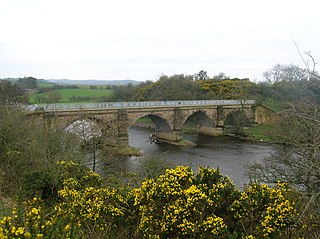
An arch bridge is a bridge with abutments at each end shaped as a curved arch. Arch bridges work by transferring the weight of the bridge and its loads partially into a horizontal thrust restrained by the abutments at either side. A viaduct may be made from a series of arches, although other more economical structures are typically used today.

The River Dearne South Yorkshire, England flows roughly east for more than 30 kilometres (19 mi), from its source just inside West Yorkshire. It flows through Denby Dale, Clayton West, Darton, Barnsley, Darfield, Wath upon Dearne, Bolton on Dearne, Adwick upon Dearne and Mexborough to its confluence with the River Don at Denaby Main. Its main tributary is the River Dove, which joins it at Darfield. The river was one of those affected by the 2007 United Kingdom floods.

Charles Bridge is a historic bridge that crosses the Vltava (Moldau) river in Prague, Czech Republic. Its construction started in 1357 under the auspices of King Charles IV, and finished in the beginning of the 15th century. The bridge replaced the old Judith Bridge built 1158–1172 that had been badly damaged by a flood in 1342. This new bridge was originally called Stone Bridge or Prague Bridge but has been "Charles Bridge" since 1870. As the only means of crossing the river Vltava until 1841, Charles Bridge was the most important connection between Prague Castle and the city's Old Town and adjacent areas. This "solid-land" connection made Prague important as a trade route between Eastern and Western Europe.

The Jubilee River is a hydraulic channel in southern England. It is 11.6 km (7.2 mi) long and is on average 45 metres wide. It was constructed in the late 1990s and early 2000s to take overflow from the River Thames and so alleviate flooding to areas in and around the towns of Maidenhead, Windsor, and Eton in the counties of Berkshire and Buckinghamshire. It achieves this by taking water from the left bank of the Thames upstream of Boulter's Lock near Maidenhead and returning it via the north bank downstream of Eton. Although successful in its stated aims, residents of villages downstream, such as Wraysbury, claim it has increased flooding.

William Edwards was a Welsh Methodist minister who also practised as a stonemason, architect and bridge engineer.

The A217 is a road in Greater London and Surrey in the United Kingdom. It runs south, from Kings Road in Fulham, London, crosses the Thames at Wandsworth Bridge, then passes through Wandsworth, Tooting, Mitcham, Rosehill and Sutton Common in Sutton, then Cheam and, as a dual carriageway accordingly at times beset by illegal racing, the Belmont southern slope of Sutton. The road enters the North Downs part of Surrey in skirting past Banstead and through its late 19th century offspring villages particularly Burgh Heath and Kingswood, Surrey, crosses the M25 motorway at Junction 8, then after returning to single carriageways, passes through the castle town of Reigate and the substantial buffer zones of two rural villages and terminates at the main roads network forming Gatwick Airport's northern perimeter.
A low-water crossing provides a bridge when water flow is low. Under high-flow conditions, water runs over the roadway and precludes vehicular traffic. This approach is cheaper than building a bridge to raise the level of the road above the highest flood stage of a river, particularly in developing countries or in semi-arid areas with rare high-volume rain. Low-water crossings can be dangerous when flooded.

The Hernando de Soto Bridge is a through arch bridge carrying Interstate 40 across the Mississippi River between West Memphis, Arkansas, and Memphis, Tennessee. The architectural design is a continuous cantilevered cable-stayed steel through arch, with bedstead endposts. Memphians also call the bridge the "New Bridge", as it is newer than the Memphis & Arkansas Bridge downstream, and the "M Bridge", due to its distinctive shape. It is of similar construction to the Sherman Minton Bridge between Louisville, Kentucky, and New Albany, Indiana.

The Marco Polo Bridge or Lugou Bridge (卢沟桥) is a stone bridge located 15 km southwest of Beijing city center in the Fengtai District. It bridges the Yongding River, a major tributary of Hai River. Situated at the eastern end of the bridge is the Wanping Fortress, a historic 17th-century fortress, with the Museum of the War of Chinese People's Resistance Against Japanese Aggression inside.
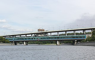
Luzhniki Metro Bridge, also known as Metromost (Метромост), is a concrete double-decked (two-level) arch bridge carrying a road and a Moscow Metro line across the Moskva River in Moscow, Russia. It connects the neighbourhood of Luzhniki Stadium to Sparrow Hills. The bridge houses Vorobyovy Gory, the only station of Moscow Metro located over water. Designed in 1958 by V.G. Andreyev and N.N. Rudomasin, the bridge rapidly decayed and was rebuilt in 1997–2002.

The Nysa Bridge is a late imperial Roman bridge over the Cakircak stream in Nysa in the ancient region of Caria, modern-day Turkey. The 100 m (328 ft) long substructure was the second largest of its kind in antiquity, after the Pergamon Bridge.

The Pergamon Bridge is a Roman substruction bridge over the Selinus river in the ancient city of Pergamon, modern-day Turkey. The 196 m (643 ft) wide structure, the largest of its kind in antiquity, was designed during Hadrian's reign (AD 117–138) in order to form a passageway underneath a large court in front of the monumental "Red Basilica" temple complex. The two intact tubes, which consist of supporting walls covered with barrel vaults, still serve their purpose to this day.
The Adyar or Adayar, originating near the Chembarambakkam Lake in Kanchipuram district, is one of the three rivers which winds through Chennai (Madras), Tamil Nadu, India, and joins the Bay of Bengal at the Adyar estuary. The 42.5-kilometre (26.4 mi) long river contributes to the estuarine ecosystem of Chennai. Despite the high pollution levels, boating and fishing take place in this river. The river collects surplus water from about 200 tanks and lakes, small streams and the rainwater drains in the city, with a combined catchment area of 860 square kilometres (331 sq mi). Most of the waste from the city is drained into this river and the Cooum.

Tullibody Old Bridge, over the River Devon near Tullibody, Clackmannanshire, Scotland, dates from the early 16th century. Disused after 1915, it was restored for use by walkers and cyclists in 2003.

The Samuel Morey Memorial Bridge is a historic bridge carrying New Hampshire Route 25A across the Connecticut River between Orford, New Hampshire and Fairlee, Vermont. The steel through-arch bridge was built in 1937–38 to replace an older wooden bridge which had been damaged by flooding in 1936. It spans 432 feet (132 m), stands about 35 feet (11 m) above the river, and its arches rise 85 feet (26 m) above the roadway. It rests on poured concrete abutments that have a light Art Deco or Moderne styling. Wing walls recede from the abutments into the banks in three stepped sections. Below the bridge in the river is visible some riprap, stone remnants of the old bridge's abutments and central pier. The bridge is of a "tied arch" design, in which the two arches are joined together by ties to distribute the active load. This is in contrast to the Justice Harlan Fiske Stone Bridge joining Brattleboro, Vermont and Chesterfield, New Hampshire, which was built about the same time, and distributes the active load to its abutments. The bridge components were manufactured by the American Bridge Company; construction was by Hagen-Thibodeau Construction Company at a contracted cost of just over $209,000.

