Floods in Bangladesh

Last updated

Bangladesh, being situated on the Brahmaputra River Delta (also known as the Ganges Delta) is a land of many rivers, and as a result is very prone to flooding. Due to being part of such a basin and being less than 5 meters above mean sea level, Bangladesh faces the cumulative effects of floods due to water flashing from nearby hills, the accumulation of the inflow of water from upstream catchments, and locally heavy rainfall enhanced by drainage congestion. Bangladesh faces this problem almost every year. Coastal flooding, combined with the bursting of river banks is common, and severely affects the landscape and society of Bangladesh. 80% of Bangladesh is floodplain, [1] and it has an extensive sea coastline, [2] rendering the nation very much at risk of periodic widespread damage. Whilst more permanent defenses, strengthened with reinforced concrete, are being built, many embankments are composed purely of soil and turf and made by local farmers. Flooding normally occurs during the monsoon season from June to September. The convectional rainfall of the monsoon is added to by relief rainfall caused by the Himalayas. Meltwater from the Himalayas is also a significant input.

Contents

In late summer 2002, heavy monsoon rains led to massive flooding in eastern India, Nepal, and Bangladesh, killing over 500 people and leaving millions homeless. This true-color image, acquired by the Moderate Resolution Imaging Spectroradiometer (MODIS) aboard NASA's Terra spacecraft begins on August 5, 2002, shows the extent of this flooding. In the upper right-hand corner of the image, the swollen Brahmaputra River runs east to west through the Indian state of Assam. Normally, the river and its tributaries would resemble a tangle of thin lines. Moving to the upper left-hand corner, flooding can be seen along the Ganges River in the state of Bihar, India. Bangladesh.A2002279.0450.267.1km.jpg
In late summer 2002, heavy monsoon rains led to massive flooding in eastern India, Nepal, and Bangladesh, killing over 500 people and leaving millions homeless. This true-color image, acquired by the Moderate Resolution Imaging Spectroradiometer (MODIS) aboard NASA's Terra spacecraft begins on August 5, 2002, shows the extent of this flooding. In the upper right-hand corner of the image, the swollen Brahmaputra River runs east to west through the Indian state of Assam. Normally, the river and its tributaries would resemble a tangle of thin lines. Moving to the upper left-hand corner, flooding can be seen along the Ganges River in the state of Bihar, India.

Each year, on average, 31,000 square kilometres (12,000 sq mi) (around 21% of the country) is flooded. During severe floods the affected area may exceed two-thirds of the country, as was seen in 1998. [3] Only about 20% of streamflow is generated by rainfall within Bangladesh. The other 80% flows in from catchment areas outside the country, overwhelmingly via three main rivers: the Ganges, the Brahmaputra-Jamuna and the Meghna. [4] The floods have caused devastation in Bangladesh throughout history, especially in 1951, 1987, 1988 and 1998. The (2007 South Asian floods) also affected a large portion of Bangladesh.

Benefits of flooding

Small scale flooding in Bangladesh is required to sustain the agricultural industry, as sediment deposited by floodwaters fertilises fields. The water is required to grow rice, so natural flooding replaces artificial irrigation, which is time-consuming and costly to build. Salt deposited on fields from high rates of evaporation is removed during floods, preventing the land from becoming infertile. The benefits of flooding are clear in El Niño years when the monsoon is interrupted. As El Niño becomes increasingly frequent, and flood events appear to become more extreme, the previously reliable monsoon may be succeeded by years of drought or devastating floods. Despite all of this, floodings also have very positive effects and it is that corn grows on the water, with the floodings corn can grow benefiting agriculture and the economy in the area.[ citation needed ]

Types of floods

While the issue of flooding and the ongoing efforts to limit its damages are prevalent throughout the entire country, several types of floods have recently occurred regularly, affecting different areas in their own distinct way. These flood types include: [5]

Historic floods

Dozens of villages were inundated when rain pushed the rivers of northwestern Bangladesh over their banks in early October 2005. The Moderate Resolution Imaging Spectroradiometer (MODIS) on NASA's Terra satellite captured the top image of the flooded Ghaghat and Atrai Rivers on October 12, 2005. The deep blue of the rivers is spread across the countryside in the flood image. BDF0.jpg
Dozens of villages were inundated when rain pushed the rivers of northwestern Bangladesh over their banks in early October 2005. The Moderate Resolution Imaging Spectroradiometer (MODIS) on NASA's Terra satellite captured the top image of the flooded Ghaghat and Atrai Rivers on October 12, 2005. The deep blue of the rivers is spread across the countryside in the flood image.

The country has a long history of destructive flooding that has had very adverse impacts on lives and property. In the 19th century, six major floods were recorded: 1842, 1858, 1871, 1875, 1885 and 1892. Eighteen major floods occurred in the 20th century. Those of 1951, 1987, 1988 and 1998 were of catastrophic consequence. More recent floods include 2004 and 2010.

The catastrophic floods of 1987 occurred throughout July and August [6] and affected 57,300 square kilometres (22,100 sq mi) of land, (about 40% of the total area of the country) and was estimated as a once in 30-70 year event. The seriously affected regions were on the western side of the Brahmaputra, the area below the confluence of the Ganges and the Brahmaputra and considerable areas north of Khulna.

The flood of 1988, which was also of catastrophic consequence, occurred throughout August and September. The waters inundated about 82,000 square kilometres (32,000 sq mi) of land, (about 60% of the area) and its return period was estimated at 50–100 years. Rainfall together with synchronisation of very high flows of the three major rivers of the country in only three days aggravated the flood. Dhaka, the capital of Bangladesh, was severely affected. The flood lasted 15 to 20 days.

In 1998, over 75% of the total area of the country was flooded, including half of Dhaka. [7] It was similar to the catastrophic flood of 1988, in terms of the extent of the flooding. A combination of heavy rainfall within and outside the country and synchronisation of peak flows of the major rivers contributed to the flood. 30 million people were made homeless and the death toll reached over a thousand. [7] The flooding caused contamination of crops and animals and unclean water resulted in cholera and typhoid outbreaks. Few hospitals were functional because of damage from the flooding, and those that were open had too many patients, resulting in everyday injuries becoming fatal due to lack of treatment. 700,000 hectares of crops were destroyed, [8] 400 factories were forced to close, and there was a 20% decrease in economic production. Communication within the country also became difficult.

The 1999 floods, [9] although not as serious as the 1998 floods, were still very dangerous and costly. The floods occurred between July and September, causing many deaths, and leaving many people homeless. The extensive damage had to be paid for with foreign assistance. The entire flood lasted approximately 65 days.

The 2004 flood was very similar to the 1988 and 1998 floods with two thirds of the country under water.

In early October 2005, dozens of villages were inundated when rain caused the rivers of northwestern Bangladesh to burst their banks.The floods that hit Bangladesh in 2007 affected 252 villages in 40 districts causing millions of people became homeless.

Floods also occurred in 2015 and 2017.

Details of the 2017 flood(s) in Bangladesh

2017 Flood situation in Bangladesh 2017 Flood recession and rise areas of Bangladesh between (a) April and June, (b) June and August.jpg
2017 Flood situation in Bangladesh

In 2017, unpredicted early heavy rain caused flooding in several parts of Bangladesh and damaged pre-harvested crops in April. The April flood continued until the last week of August and caused substantial damage to housing, property, and infrastructure. Inundation maps of Bangladesh for March, April, June, and August 2017, based on Sentinel-1 images, show that in March 2017 perennial waterbodies covered 5.03% of Bangladesh. In April, a total flood-inundated area was 2.01%, most inundation occurring in cropland (1.51%), followed by rural settlement and homestead orchard areas (0.21%) and other areas (0.29%). Similarly, more area was inundated during the catastrophic June and August months, with inundation covering 4.53% and 7.01%, respectively. [10]

Climate variability

Population density and height above sea level in Bangladesh (2010). Bangladesh is especially vulnerable to sea level rise. Urban-Rural Population and Land Area Estimates, v2, 2010 Bangladesh (13873798283).jpg
Population density and height above sea level in Bangladesh (2010). Bangladesh is especially vulnerable to sea level rise.

From March to September in a typical year, the citizens of Bangladesh are the most susceptible to major flooding, as a mixture of the monsoon seasons and the rising of major rivers and their tributaries reach their peak as the snow starts to melt and the rain starts to pour. [5]

the rivers flow from India into Bangladesh also sometimes the Himalayas.

Widespread flooding in Bangladesh, as seen in 1988, 1998 and 1991 has caused widespread destruction in one of the least developed countries in the world. With three of the world's mightiest river systems and being situated in the world's largest delta, riverbank erosion is taking away precious land from the small nation with a growing population every year. The economic development of the rural sphere is largely intertwined, as every year the populace loses property and livelihood. South Asian people, 70 percent of whom lives in rural areas also account for 75 percent of the poor, most of whom rely on agriculture for their livelihood. Each year they are disproportionately affected by the effects of climate change. Three catastrophes—the 1991 Bangladesh cyclone, the May 1997 Bangladesh cyclone and Cyclone Sidr in 2007—cost the nation around a quarter of a million of its residents. There needs to be serious considerations to mitigate the effects of climate change and invest in capacity building of each system component to secure the future of this country.

This global change is likely to have a more dramatic effect on the global agriculture than previously predicted meaning that the world hunger situation and Bangladesh's food security issues will only get worse. [11] The difference between historical and projected average temperatures each season throughout the world has revealed that harvests from major staple crops could drop by 40 percent by the end of the 21st century due to high temperatures in the growing seasons. A research study predicted this by using the patterns and characteristics of 23 global climate models. Not only are the harvests affected, the grain yield is also predicted to decrease anywhere from 3 to 15 percent. [12] The overall damage:

Flood preparation

Yearly flooding during monsoon season and other forms of inclement weather have forced the people of Bangladesh to adjust their lifestyle in order to prepare for the worst. One thing that people are doing to avoid the effects of the flooding is building elevated houses and roads. The raised houses are built on platforms raised above the typical water level a flood can reach. In many cases, neighbourhoods of people build these raised homes and roads, creating a "cluster village" which is essentially a village that is raised above flood level. This has proven to be very effective at avoiding the immediate effects of flooding. [14]

Additionally, organisations such as the Global Fund for Children and the Bill & Melinda Gates Foundation have taken the initiative of helping kids rebuild their lives after natural disasters by building schools that function on boats themselves. "Floating schools", as these classrooms are known, help provide an education for children whose lives were drastically affected by the effects of constant flooding. Furthermore, children who even prior to a natural disaster did not receive proper schooling benefited from the opening of floating schools, making these communities into beneficial learning spots. [15]

However, there are effects from flooding that cannot be avoided simply by raising houses above flood level. Water contamination, for example, is very difficult to cope with during floods. Because of this, many people in Bangladesh use a tube well, which is a well with a top that is raised high enough that contaminated flood water from a flood cannot enter it. Many cities also have flood shelters, which are large raised platforms where people can find refuge from the effects of the on-rushing flood. [14] As a result of several demanding summer floods, in 2004, the government of Bangladesh made the step of seeking foreign aid rather than try to assist the millions of homeless people on their own. Nearly all the 147 million people living in Bangladesh at the time (crammed into a space the size of Iowa) were forced to adapt to intense rainfall and water-borne disease exposed conditions. An increase of salinity, a lack of food distributors, and the effects of seeing slum dwellers survive on flood water were just the initial blows to a monumental flood season that summer, extending beyond Bangladesh's borders and affecting India, China, Nepal, and Vietnam as well. [13]

These may be great solutions to the problem of flooding, but some cities do not have raised houses or flood shelters. These cities typically have rescue boats that can search for people who were unable to get above flood level and help them get out of the water. These boats are very important; they rescue over a thousand people over the course of multiple years. [14]

Flood shelter suitability areas in Bangladesh

Recognized priority area for flood emergency shelter construction based on the bivariate choropleth analysis using flood shelter suitability and flood hazard maps in Bangladesh. Priority area for flood shelter construction based on the bivariate choropleth analysis using flood hazard and flood shelter suitability maps in Bangladesh..jpg
Recognized priority area for flood emergency shelter construction based on the bivariate choropleth analysis using flood shelter suitability and flood hazard maps in Bangladesh.

To mitigate flood disasters impact, it is crucial to understand the areas that are flooded by water. At the same time, flood-affected families also can get a safe location to shelter. In Bangladesh, most rural homes are situated in low-lying floodplain regions, which are highly vulnerable to flooding. Many of these residences inundate during flooding and come to be unsuitable for habitation. In this case, emergency lodging in temporary flood shelters is necessary for the affected families. The place of the flood shelter concerning the distance from the community and accessibility is crucial for useful evacuation and relocation. The flood shelter must be accessible and close to a settlement to ensure efficient evacuation and relocation. [17]

On the other hand, the shelters should be built in an area free from the risk of flooding. Over time, a good number of safe cyclone shelters have been established in the coastal regions of Bangladesh. However, in the flood-prone northern and central regions and the flood-prone area near the major rivers, a small number of designated flood emergency shelters exist other than a few elevated homesteads. In most cases, these small figures of flood shelters are not located in flood-prone areas to evacuate most people. Therefore, many factors related to flood pronouns, protection, and convenience, should be considered when identifying suitable sites for flood shelters. In this case, remote sensing and geographic information system can play a vitally important role in finding suitable locations for flood shelters. [16]

Coverage of inundation and deaths in major floods, 1954-1998

[18]

YearFlooded area (km2)Percentage of total areaNumber of deaths
19543692025112
19555070034129
19563562024
19623740425117
19634318029
19683730025126
1970426402887
19713647524120
197452720351987
19842831419513
198757491391657
198877700522379
1998100000671050

Table of flood damage in Bangladesh (1953-1998)

YearCrop damage (million tons)Total financial loss (million taka)
19530.6
19540.71500
19560.51580
19621.21500
19661.0600
19681.11200
19691.01100
19701.21000
19741.420000
19800.44000
19840.74500
19871.535000
19883.240000
19984.5142160

[19]

See also

Related Research Articles

<span class="mw-page-title-main">Geography of Bangladesh</span> Geography of Bangladesh

Bangladesh is a densely populated, low-lying, mainly riverine country located in South Asia with a coastline of 580 km (360 mi) on the northern littoral of the Bay of Bengal. The delta plain of the Ganges (Padma), Brahmaputra (Jamuna), and Meghna Rivers and their tributaries occupy 79 percent of the country. Four uplifted blocks occupy 9 percent and steep hill ranges up to approximately 1,000 metres (3,300 ft) high occupy 12 percent in the southeast and in the northeast. Straddling the Tropic of Cancer, Bangladesh has a tropical monsoon climate characterised by heavy seasonal rainfall, high temperatures, and high humidity. Natural disasters such as floods and cyclones accompanied by storm surges periodically affect the country. Most of the country is intensively farmed, with rice the main crop, grown in three seasons. Rapid urbanisation is taking place with associated industrial and commercial development. Exports of garments and shrimp plus remittances from Bangladeshis working abroad provide the country's three main sources of foreign exchange income.

<span class="mw-page-title-main">Brahmaputra River</span> River in Tibet, India and Bangladesh

The Brahmaputra is a trans-boundary river which flows through Tibet (China), Northeastern India, and Bangladesh. It is known as Brahmaputra or Luit in Assamese,Yarlung Tsangpo in Tibetan, the Siang/Dihang River in Arunachali and Jamuna River in Bengali. It is the 9th largest river in the world by discharge, and the 15th longest.

<span class="mw-page-title-main">Natural disasters in India</span> Natural disasters in India

Natural calamities in India, many of them related to the climate of India, cause massive losses of life and property. Droughts, flash floods, cyclones, avalanches, landslides brought by torrential rains, and snowstorms pose the greatest threats. A natural disaster might be caused by earthquakes, flooding, volcanic eruption, landslides, hurricanes etc. In order to be classified as a disaster, it will need to have a profound environmental effect and/or human loss and frequently incurs a financial loss. Other dangers include frequent summer dust storms, which usually track from north to south; they cause extensive property damage in North India and deposit large amounts of dust and dirt from arid regions. Hail is also common in parts of India, causing severe damage to standing crops such as rice and wheat and many more crops and effects many people.

<span class="mw-page-title-main">2007 South Asian floods</span> Natural disaster impacting large numbers of people in various Asian countries

The 2007 South Asian floods were a series of floods in India, Pakistan, Bhutan, Nepal and Bangladesh. News Agencies, citing the Indian and Bangladeshi governments, place the death toll in excess of 2,000. By 3 August, approximately 20 million had been affected and by 10 August some 30 million people in India, Bangladesh and Nepal had been affected by flooding.

<span class="mw-page-title-main">October 1999 Mexico floods</span> 1999 flood in Mexico

In October 1999, severe flooding affected portions of eastern Mexico and Central America. Rainfall in September preceded the primary event in Mexico, which moistened soils. On October 4, Tropical Depression Eleven developed in the Gulf of Mexico, which drew humidity from the gulf and the Pacific Ocean to produce torrential rainfall in mountainous regions of eastern Mexico, reaching 43.23 in (1,098 mm) in Jalacingo, Veracruz. This was the third-highest tropical cyclone-related rainfall total in Mexico from 1980–2006, and the event caused the highest rainfall related to tropical cyclones in Veracruz, Hidalgo, and Puebla. In some locations, the daily rainfall represented over 10% of the annual precipitation total. The heaviest rainfall occurred in mountainous regions that were the mouths of several rivers. A broad trough absorbed the depression on October 6, and rainfall continued for the next few days. Additional rainfall occurred in Tabasco state on October 18. The floods were estimated as a 1 in 67 year event in one location, although such floods are expected to affect eastern Mexico twice per century, the last time being 1944.

<span class="mw-page-title-main">Climate of Pakistan</span> Overview of climate of Pakistan

Pakistan's climate varies from a continental type of climate in the north, a mountainous dry climate in the west (Baluchistan), a wet climate in the East (Punjab) an arid climate in the Thar Desert, to a tropical climate in the southeast (Sindh), characterized by extreme variations in temperature, both seasonally and daily, because it is located on a great landmass barely north of the Tropic of Cancer.

<span class="mw-page-title-main">Cyclone Aila</span> North Indian Ocean cyclone in 2009

Severe Cyclonic Storm Aila was the second named tropical cyclone of the 2009 North Indian Ocean cyclone season. Warned by both the Regional Specialized Meteorological Center (RMSC) and Joint Typhoon Warning Center (JTWC), Aila formed over a disturbance over the Bay of Bengal on May 23, 2009 and started to intensify and organize reaching sustained wind speeds of 110 kmh (70 mph). It was the worst natural disaster to affect Bangladesh since Cyclone Sidr in November 2007. A relatively strong tropical cyclone, it caused extensive damage in India and Bangladesh.

<span class="mw-page-title-main">Climate of Asia</span> Overview of the climate of Asia

The climate of Asia is dry across its southwestern region, with dry across much of the interior. Some of the largest daily temperature ranges on Earth occur in the western part of Asia. The monsoon circulation dominates across the southern and eastern regions, due to the Himalayas forcing the formation of a thermal low which draws in moisture during the summer. The southwestern region of the continent experiences low relief as a result of the subtropical high pressure belt; they are hot in summer, warm to cool in winter, and may snow at higher altitudes. Siberia is one of the coldest places in the Northern Hemisphere, and can act as a source of arctic air mass for North America. The most active place on Earth for tropical cyclone activity lies northeast of the Philippines and south of Japan, and the phase of the El Nino-Southern Oscillation modulates where in Asia landfall is more likely to occur. Many parts of Asia are being impacted by climate change.

<span class="mw-page-title-main">Climate change in Bangladesh</span> Emissions, effects and responses of Bangladesh related to climate change

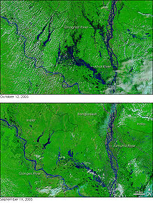
Climate change is a critical issue in Bangladesh as the country is one of the most vulnerable to the effects of climate change. In the 2020 edition of Germanwatch's Climate Risk Index, it ranked seventh in the list of countries most affected by climate calamities during the period 1999–2018. Bangladesh's vulnerability to the effects of climate change is due to a combination of geographical factors, such as its flat, low-lying, and delta-exposed topography, and socio-economic factors, including its high population density, levels of poverty, and dependence on agriculture. The impacts and potential threats include sea level rise, temperature rise, food crises, droughts, floods, and cyclones.

<span class="mw-page-title-main">Effects of Hurricane Mitch in Honduras</span>

The effects of Hurricane Mitch in Honduras were destructive and deadly, resulting in the most significant flooding in Honduras in the 20th century. Hurricane Mitch, the strongest storm of the 1998 Atlantic hurricane season, formed on October 22, and after becoming a Category 5 hurricane, it weakened and struck Honduras on October 29. While near peak intensity, Mitch struck the offshore Guanaja island, where it nearly destroyed the mangrove forest. On the mainland, the hurricane dropped torrential rainfall, and many gauges were washed away in mountainous areas where unofficial rainfall totals were as high as 1900 mm (75 in). The highest official total was 928 mm (36.5 in) at Choluteca in southern Honduras, which was more than half of the annual precipitation average there. The rains caused widespread flooding and landslides, although impact from winds was not as severe.

This is a list of notable recorded floods that have occurred in India. Floods are the most common natural disaster in India. The heaviest southwest, the Brahmaputra, and other rivers to distend their banks, often flooding surrounding areas.

<span class="mw-page-title-main">2017 West Bengal floods</span>

Following heavy rain in July and August 2017, the Indian state of West Bengal was affected by severe flooding. The floods were reported to have caused 50 deaths since 1 August and 8 deaths in the neighbouring state of Jharkhand.

The Brahmaputra floods refers to a catastrophic flood event that occurred in 2012 along the Brahmaputra River and its tributaries, as well as in subsequent years.

In mid-March 2019, monsoonal downpours caused widespread flooding and landslides across South Asia.

The 2019 Indian floods were a series of floods that affected over thirteen states in late July and early August 2019, due to excessive rains. At least 200 people died and about a million people were displaced. Karnataka and Maharashtra were the most severely affected states. People died but many were rescued with the help of the Indian Navy.

<span class="mw-page-title-main">2020 Assam floods</span> Natural disaster in Northeast India

2020 Assam floods refers to the significant flood event of the Brahmaputra River in the Indian north-eastern state of Assam and coincided with the COVID-19 pandemic. Initial flooding started in May 2020 due to heavy rainfall affecting 30,000 and destroying crops across 5 districts. As of October 2020 the floods affected over five million people, claiming the lives of 123 people, with an additional 26 deaths due to landslides, 5474 villages were affected and over one hundred and fifty thousand people found refuge in relief camps.

Beginning in May 2022, deadly floods hit northeastern India and Bangladesh. Over 9 million people in both countries have been affected, and around 300 people have been killed.

Lucknow is a city in the state of Uttar Pradesh, India. It is located on the banks of the Gomti River, which is a tributary of the Ganges River. Lucknow has a history of being affected by floods due to heavy rainfall, river overflow, and breaches in the embankments.

References

  1. H. Brammer (March 1990). "Floods in Bangladesh: Geographical Background to the 1987 and 1988 Floods". The Geographical Journal. 156 (1): 12–22. doi:10.2307/635431. JSTOR   635431.
  2. Mohd Shamsul Alam (2012), "Sea Level", in Sirajul Islam; Ahmed A. Jamal (eds.), Banglapedia: National Encyclopedia of Bangladesh (Second ed.), Asiatic Society of Bangladesh
  3. Dewan, A. M.; Nishigaki, Makoto; Komatsu, Mitsuru (March 2003). "Floods in Bangladesh: A Comparative Hydrological Investigation on Two Catastrophic Events" (PDF). Journal of the Faculty of Environmental Science and Technology, Okayama University. 8 (1): 53.
  4. Chowdhury, Sifatul Quader; Hossain, Md Sazzad (2012). "Flood". In Islam, Sirajul; Jamal, Ahmed A. (eds.). Banglapedia: National Encyclopedia of Bangladesh (Second ed.). Asiatic Society of Bangladesh.
  5. 1 2 Md. Mizanur Rahman; Md. Amirul Hossain; Amartya Kumar Bhattacharya. "Flood Management in the Flood Plain of Bangladesh".
  6. "1988 Flood Archive". Archived from the original on 2016-04-13. Retrieved 2012-03-13.
  7. 1 2 Bangladesh floods recede, but death toll rises, 17 September 1998
  8. "World: South Asia Bangladesh floods rise again", BBC News, 24 August 1998
  9. Nishanthi Priyangika (20 October 1999), Hundreds of thousands hit by Bangladesh floods, wsws.org, retrieved 27 August 2015
  10. 1 2 Uddin, Kabir; Matin, Mir A.; Meyer, Franz J. (3 July 2019). "Operational Flood Mapping Using Multi-Temporal Sentinel-1 SAR Images: A Case Study from Bangladesh". Remote Sensing. 11 (13): 1581. Bibcode:2019RemS...11.1581U. doi: 10.3390/rs11131581 .
  11. "How dire climate displacement warnings are becoming a reality in Bangladesh". The New Humanitarian. 5 March 2019. Retrieved 24 June 2019.
  12. Sunny, Sanwar (2011). Green Buildings, Clean Transport and the Low Carbon Economy: Towards Bangladesh's Vision of a Greener Tomorrow. Germany: LAP Publishers. p. 12. ISBN   978-3-8465-9333-2.
  13. 1 2 Amy Waldman (30 July 2004). "Bangladesh Now Seeks Foreign Aid For Flooding". The New York Times.
  14. 1 2 3 "Bangladesh: Preparing for Flood Disaster". Oxfam. Archived from the original on 17 May 2014.
  15. Amy Yee (1 July 2013). "'Floating Schools' Bring Classrooms to Stranded Students". The New York Times.
  16. 1 2 Uddin, Kabir; Matin, Mir A. (2021-10-01). "Potential flood hazard zonation and flood shelter suitability mapping for disaster risk mitigation in Bangladesh using geospatial technology". Progress in Disaster Science. 11: 100185. doi: 10.1016/j.pdisas.2021.100185 . ISSN   2590-0617.
  17. "Natural Calamities in Bangladesh". Teletalk Bangladesh. 24 May 2021. Retrieved 25 November 2021.
  18. Journal of the Faculty of Environmental Science and Technology, Okayama University, Vol 8, No. 1, Page: 56, March 2003
  19. Journal of the Faculty of Environmental Science and Technology, Okayama University Vol 8, No. 1, Page: 59, Table 5. March 2003

Further reading