Flora and fauna of the Kerguelen Islands

Last updated

Nesting birds of the Kerguelen Islands [1]

     Binomial name Common name
Spheniscidae
Aptenodytes patagonicus King penguin
Pygoscelis papua Gentoo penguin
Eudyptes chrysolophus Macaroni penguin
Eudyptes chrysocome Southern rockhopper penguin
  Procellariidae
Diomedea exulans Wandering albatross
Thalassarche melanophris Black-browed albatross
Thalassarche chrysostoma Grey-headed albatross
Phoebetria fusca Sooty albatross
Phoebetria palpebrata Light-mantled albatross
Macronectes halli Giant petrel
Daption capense Cape petrel
Pachyptila belcheri Slender-billed prion
Pachyptila desolata Antarctic prion
Halobaena caerulea Blue petrel
Pterodroma macroptera Great-winged petrel
Pterodroma lessonii White-headed petrel
Pterodroma brevirostris Kerguelen petrel
Procellaria aequinoctialis White-chinned petrel
Procellaria cinerea Grey petrel
  Hydrobatidae
Oceanites oceanicus Wilson's storm-petrel
Fregetta tropica Black-bellied storm-petrel
Garrodia nereis Grey-backed storm-petrel
  Pelecanoididae
Pelecanoides georgicus South Georgian diving petrel
Pelecanoides urinatrix Common diving petrel
  Phalacrocoracidae
Phalacrocorax verrucosus Kerguelen shag
  Anatidae
Anas eatoni Eaton's pintail
  Chionididae
Chionis minor Black-faced sheathbill
  Stercorariidae
Stercorarius skua Great skua
  Laridae
Larus dominicanus Kelp gull
Sterna virgata Kerguelen tern
Sterna vittata Antarctic tern

The Kerguelen Islands are part of the Southern Indian Ocean Islands tundra ecoregion that includes several subantarctic islands. In this cold climate plant life is mainly limited to grasses, mosses and lichens, although the islands are also known for the indigenous edible Kerguelen cabbage. The islands are at the Antarctic convergence, where cold water moving up from the Antarctic mixes with the warmer water of the Indian Ocean. As a consequence, marine mammals, especially seals, and seabirds and penguins are numerous. [2]

Contents

Fauna

Mammals

Seals and fur seals:

Cetaceans:

Introduced land mammals:

Birds

Black-faced sheathbill (Chionis minor) Chionis minor.JPG
Black-faced sheathbill (Chionis minor)

Penguins:

Seabirds:

The Kerguelen Islands are covered by France's ratification of the international Agreement on the Conservation of Albatrosses and Petrels, drawn up under the auspices of the Convention on Migratory Species.

Anseriformes:

Fish

In the 1950s and 1960s, Edgar Albert de la Rue, a French geologist began the introduction of several species of salmonids. Of the seven species introduced, only brook trout Salvelinus fontinalis and brown trout Salmo trutta survived to establish wild populations. [6] Brook trout occupy head water streams, while brown trout have established both resident stream and robust anadromous populations throughout the islands.

Flora

Land vegetation

Kerguelen cabbage in a field of Acaena. Choux.kerguelen.jpg
Kerguelen cabbage in a field of Acaena .

The coastal regions, up to an altitude of about 50 m, are generally covered with low herbaceous vegetation, and are classified as tundra. Higher up, rocky ground dominates and the vegetation is rarer, limited to scattered tufts and mosses and lichens.

There are no trees or shrubs on the islands. This was not always the case, however. Fossilized tree trunks of the family Araucariaceae can be found in certain sediments, geological witnesses of times when Kerguelen had a warmer climate than today.

Originally, the main type of low altitude vegetation consisted of a thick and continuous carpet of azorellae ( Azorella selago ) on which could be established various other species such as the famous Kerguelen cabbage, Pringlea antiscorbutica (family Brassicaceae). The azorella (Apiaceae) had a pillow-shaped growth: the year's growth forming a tight layer which superimposed itself on the previous year's growth. The species Lyallia kerguelensis (Hectorellaceae), the only strictly endemic species of the archipelago, has a similar growth pattern. The pillows of azorellae could exceed 1 meter in thickness and adjacent plants could join to form a continuous sheet. Walking on this kind of vegetation was very difficult and was environmentally harmful. On the other hand, this tender medium was ideal for certain species of marine birds which could dig nest burrows there.

The introduction and proliferation of rabbits destroyed this habitat, which was replaced by a monospecific meadow constituted of a plant resembling a small Salad Burnet, Acaena adscendens (Rosaceae). Today one can find the carpets of azorellae only on the islands and islets undamaged by rabbits. The Kerguelen cabbage underwent practically the same fate. The establishment of other mammals also had consequences on the vegetation: consumption of the seeds of the Kerguelen cabbage by mice, reducing its regeneration capacities, consumption of the lichens by reindeer, etc.

In the flat bottoms and close to brooks, the ground is often soaked. A boggy vegetation mainly constituted of mosses may develop there. This vegetation can appear homogeneous on the surface but can be covering quicksand, in which hikers may sink to the waist.

Marine vegetation

Thin straps of floating Durvillaea forming a coastal belt Durvillea antarctica.JPG
Thin straps of floating Durvillaea forming a coastal belt
Kelp beds off the coast of the Kerguelen Islands as seen from space Kerguelen Kelp Beds, Southern Indian Ocean.jpg
Kelp beds off the coast of the Kerguelen Islands as seen from space

Unlike the terrestrial vegetation which is very poorly developed, the marine flora is flourishing, in particular thanks to the presence of giant brown algae: the kelp ( Macrocystis pyrifera ), which form true underwater forests, and the cochayuyo ( Durvillaea antarctica ), which covers most of the rock coasts.

The Macrocystis are one of the largest types of marine macroalgae, the species can grow to lengths of 50 meters, forming undersea forests in hard-bottom, subtidal areas. [7] Attached to the bottom by branched holdfasts, the algae grow up to the surface in the form of columns made of several dozen interwoven cords. They then spread out widely on the surface thanks to floaters placed at the base of multiple slings similar to corrugated sheets. The kelp can cover wide areas where navigation is practically impossible because the thin straps can get entangled in ships' propellers and block them. The kelp forests in the Kerguelen Islands are home to relatively few vertebrates but many colourful invertebrates as well as a great diversity of red algae. The storms regularly tear off large quantities of giant algae that wash ashore and rot on the beaches in the form of a mattress which can reach several meters thickness. These wash-ups of algae form one of the essential bases of the local ecosystem.

Related Research Articles

Heard Island and McDonald Islands Australian external territory

The Territory of Heard Island and McDonald Islands (HIMI) is an Australian external territory comprising a volcanic group of mostly barren Antarctic islands, about two-thirds of the way from Madagascar to Antarctica. The group's overall size is 372 km2 (144 sq mi) in area and it has 101.9 km (63 mi) of coastline. Discovered in the mid-19th century, the islands have been an Australian territory since 1947 and contain the country's two active volcanoes. The summit of one, Mawson Peak, is higher than any mountain on the Australian mainland. The islands lie on the Kerguelen Plateau in the Indian Ocean.

Kerguelen Islands French-administered sub-Antarctic archipelago

The Kerguelen Islands, also known as the Desolation Islands, are a group of islands in the sub-Antarctic constituting one of the two exposed parts of the Kerguelen Plateau, a large igneous province mostly submerged in the southern Indian Ocean. They are among the most isolated places on Earth, located more than 3,300 km (2,100 mi) from Madagascar. The islands, along with Adélie Land, the Crozet Islands, Amsterdam and Saint Paul islands, and France's Scattered Islands in the Indian Ocean, are part of the French Southern and Antarctic Lands and are administered as a separate district.

Tundra Biome where plant growth is hindered by cold temperatures

In physical geography, tundra is a type of biome where the tree growth is hindered by low temperatures and short growing seasons. The term tundra comes through Russian тундра from the Kildin Sámi word тӯндар meaning "uplands", "treeless mountain tract". Tundra vegetation is composed of dwarf shrubs, sedges, grasses, mosses, and lichens. Scattered trees grow in some tundra regions. The ecotone between the tundra and the forest is known as the tree line or timberline. The tundra soil is rich in nitrogen and phosphorus.

Macquarie Island Sub-Antarctic island of Australia

Macquarie Island is an island in the southwestern Pacific Ocean, about halfway between New Zealand and Antarctica. Regionally part of Oceania and politically a part of Tasmania, Australia, since 1900, it became a Tasmanian State Reserve in 1978 and was inscribed as a UNESCO World Heritage Site in 1997.

Macaroni penguin Species of bird

The macaroni penguin is a species of penguin found from the Subantarctic to the Antarctic Peninsula. One of six species of crested penguin, it is very closely related to the royal penguin, and some authorities consider the two to be a single species. It bears a distinctive yellow crest, and the face and upperparts are black and sharply delineated from the white underparts. Adults weigh on average 5.5 kg (12 lb) and are 70 cm (28 in) in length. The male and female are similar in appearance; the male is slightly larger and stronger with a relatively larger bill. Like all penguins, it is flightless, with a streamlined body and wings stiffened and flattened into flippers for a marine lifestyle.

Crozet Islands Archipelago in the subantarctic French territories

The Crozet Islands are a sub-Antarctic archipelago of small islands in the southern Indian Ocean. They form one of the five administrative districts of the French Southern and Antarctic Lands.

Rockhopper penguin Common name for a type of bird

The rockhopper penguins are three closely related taxa of crested penguins that have been traditionally treated as a single species and are sometimes split into three species.

Scotia Sea Sea at the northern edge of the Southern Ocean at its boundary with the South Atlantic Ocean

The Scotia Sea is a sea located at the northern edge of the Southern Ocean at its boundary with the South Atlantic Ocean. It is bounded on the west by the Drake Passage and on the north, east, and south by the Scotia Arc, an undersea ridge and island arc system supporting various islands. The sea sits atop the Scotia Plate. It is named after the expedition ship Scotia. Many icebergs melt there.

Antipodes Subantarctic Islands tundra Ecoregion

The Antipodes Subantarctic Islands tundra ecoregion, within the tundra biome, includes five remote island groups in the Pacific Ocean south of New Zealand: the Bounty Islands, Auckland Islands, Antipodes Islands and Campbell Island groups of New Zealand, and Macquarie Island of Australia.

Polar ecology is the relationship between plants and animals in a polar environment. Polar environments are in the Arctic and Antarctic regions. Arctic regions are in the Northern Hemisphere, and it contains land and the islands that surrounds it. Antarctica is in the Southern Hemisphere and it also contains the land mass, surrounding islands and the ocean. Polar regions also contain the subantarctic and subarctic zone which separate the polar regions from the temperate regions. Antarctica and the Arctic lie in the polar circles. The polar circles are not visible on the earth but it is shown on maps to be the areas that receives less sunlight due to less radiation. These areas either receive sunlight or shade 24 hours a day because of the earth's tilt. Plants and animals in the polar regions are able to withstand living in harsh weather conditions but are facing environmental threats that limit their survival.

East Antarctica Part of Antarctica that lies within the Eastern Hemisphere

East Antarctica, also called Greater Antarctica, constitutes the majority (two-thirds) of the Antarctic continent, lying on the Indian Ocean side of the continent, separated from West Antarctica by the Transantarctic Mountains. It lies almost entirely within the Eastern Hemisphere and its name has been accepted for more than a century. It is generally higher than West Antarctica and includes the Gamburtsev Mountain Range in the center. The geographic South Pole is located within East Antarctica.

Southern Indian Ocean Islands tundra Ecoregion of several subantarctic islands in the southern Indian Ocean

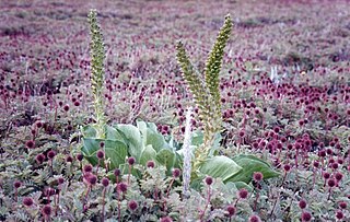
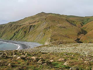
The Southern Indian Ocean Islands tundra is a tundra ecoregion that includes several subantarctic islands in the southern Indian Ocean.

Scotia Sea Islands tundra Tundra ecoregion

The Scotia Sea Islands tundra is a tundra ecoregion which includes several island groups – South Georgia and the South Sandwich Islands, South Shetland Islands, and Bouvet Island – in the Scotia Sea, where the South Atlantic Ocean meets the Southern Ocean. Most of the terrain is covered with snow and permanent ice, with tundra vegetation - moss, lichen, and algae - on the remainder. The islands support important rookeries for seals, seabirds, and penguins. The islands have no permanent human habitation, and the cold, harsh climate and ending of seal hunting and whaling has prevented settlement.

Northern rockhopper penguin Species of bird

The northern rockhopper penguin, Moseley's rockhopper penguin, or Moseley's penguin is a penguin species native to the southern Indian and Atlantic Oceans. It is described as distinct from the southern rockhopper penguin.

Wildlife of Antarctica Antarctic wildlife

The wildlife of Antarctica are extremophiles, having to adapt to the dryness, low temperatures, and high exposure common in Antarctica. The extreme weather of the interior contrasts to the relatively mild conditions on the Antarctic Peninsula and the subantarctic islands, which have warmer temperatures and more liquid water. Much of the ocean around the mainland is covered by sea ice. The oceans themselves are a more stable environment for life, both in the water column and on the seabed.

Wildlife of Iceland

The wildlife of Iceland is the wild plant and animal life found on the island of Iceland, located in the north Atlantic Ocean just south of the Arctic Circle. The flora and fauna is limited by the geography and climate of the island. The habitats on the island include high mountains, lava fields, tundras, rivers, lakes and a coastal plain of varying width. There is a long coastline, much dissected by fjords, especially in the west, north and east, with many offshore islets.

Wildlife of Norway

The wildlife of Norway includes the diverse flora and fauna of Norway. The habitats include high mountains, tundras, rivers, lakes, wetlands, sea coast and some lower cultivated land in the south. Mainland Norway has a long coastline, protected by skerries and much dissected by fjords, and the mostly-icebound archipelago of Svalbard lies further north. The flora is very varied and a large range of mammals, birds, fish and invertebrate species live here, as well as a few species of reptiles and amphibians.

Baie de l'Oiseau is a natural harbour in the Loranchet Peninsula, in the North-Western part of the island Grande Terre, part of the Kerguelen Islands. It was the landing site of the expedition under Yves de Kerguelen in 1772, and later of the expedition under James Cook in 1776. The site of Port-Christmas is part of the bay.

References

  1. A la découverte des terres australes et antarctiques françaises, P. Jouventin, Muséum d'histoire naturelle de Marseille, 1983
  2. "Southern Indian Ocean Islands tundra". Terrestrial Ecoregions. World Wildlife Fund.
  3. "Rare Type D Orcas: Never Before Seen Footage". 6 January 2015.
  4. Bilan d'activités 2012 - Taaf Archived 2016-03-03 at the Wayback Machine , page 28.
  5. Kidder, J. H. (April 1876). "An Interesting Bird"  . Popular Science Monthly . Vol. 8. ISSN   0161-7370 via Wikisource. [ scan   Wikisource-logo.svg ]
  6. Newton, Chris (2013). "The Monsters of Kerguelen". The Trout's Tale - The Fish That Conquered an Empire. Ellesmere, Shropshire: Medlar Press. pp. 161–170. ISBN   978-1-907110-44-3.
  7. "NASA Earth Observatory". Kerguelen Kelp Beds, Southern Indian Ocean. 2 March 2009. Retrieved 2009-04-12.