
St. Lucie County is located in the southeastern portion of the U.S. state of Florida. As of the 2020 census, the population was 329,226. The county's seat is Fort Pierce, while the largest city is Port St. Lucie, making up 62% of the county's population. St. Lucie County is the principal county of the Port St. Lucie, FL Metropolitan Statistical Area.

Fort Pierce is a city in and the county seat of St. Lucie County, Florida, United States. The city is part of the Treasure Coast region of Atlantic Coast Florida. It is also known as the Sunrise City. Per the 2020 census, the population was 47,297.
The Miami metropolitan area, also known as South Florida, SoFlo, SoFla, the Gold Coast, the Tri-County Area, or Greater Miami, and officially the Miami–Fort Lauderdale–West Palm Beach Metropolitan Statistical Area, is a coastal metropolitan area in southeastern Florida. It is the ninth-largest metropolitan statistical area (MSA) in the United States, the second-largest metropolitan area in the Southern United States, and the largest metropolitan area in Florida. With a population of 6.14 million, its population exceeds 31 of the nation's 50 states as of 2022. It comprises the three most populated counties in the state, Miami-Dade County, Broward County, and Palm Beach County, which rank as the first, second, and third-most populous counties in the state, respectively. Miami-Dade County, with 2,716,940 people in 2019, is the seventh-most populous county in the United States.

South Florida, sometimes colloquially shortened to SoFlo, is the southernmost region of the U.S. state of Florida. It is one of Florida's three most commonly referred to directional regions; the two others are Central Florida and North Florida. South Florida is the southernmost part of the continental United States and the only region of the continental U.S. that includes some areas with a tropical climate.
The Treasure Coast is a region in the southeast of the U.S. state of Florida. It borders the Atlantic Ocean and comprises Indian River, Martin, and St. Lucie counties. The region, whose name refers to the Spanish Treasure Fleet that was lost in a 1715 hurricane, evidently emerged from residents' desire to distinguish themselves from the Gold Coast to the south.

Florida's 14th congressional district is an electoral district for the U.S. Congress and includes western Hillsborough County and southeastern Pinellas County, including most of Tampa. In the 2020 redistricting cycle, the district was redrawn to include almost all areas in both counties which face Tampa Bay, while northeastern Tampa and its neighbouring suburbs are redistricted into the 15th district. The 14th district also includes MacDill Air Force Base and Tampa International Airport.

Florida's 9th congressional district is a congressional district in the U.S. state of Florida. It stretches from eastern Orlando south-southeast to Yeehaw Junction. It also includes the cities of Kissimmee and St. Cloud.

Florida's 24th congressional district is an electoral district for the U.S. Congress, located in southeast Florida. It was redrawn after the 2020 U.S. census. This district includes parts of Miami north of Florida State Road 112, including Little Haiti, as well as Brownsville, Biscayne Park, North Miami, Miami Gardens, and Opa Locka, along with the southern Broward County communities of Pembroke Park, West Park, and parts of Miramar. In the 2020 redistricting cycle, the district was drawn to include parts of barrier islands northeast of Miami, including Miami Beach and Surfside, while all of Hollywood became part of the new 25th district as Country Club and some of Miami, including Allapattah and Wynwood, became part of the new 26th district.

U.S. Highway 1 (US 1) in Florida runs 545 miles (877 km) along the state's east coast from Key West to its crossing of the St. Marys River into Georgia north of Boulogne and south of Folkston. US 1 was designated through Florida when the U.S. Numbered Highway System was established in 1926. With the exception of Monroe County, the highway runs through the easternmost tier of counties in the state, connecting numerous towns and cities along its route, including nine county seats. The road is maintained by the Florida Department of Transportation (FDOT).

Florida's 25th congressional district is a congressional district in the Greater Miami area of Florida. In the 2020 redistricting cycle, it was drawn as a successor to the previous 23rd district and includes much of southern Broward County, including Weston, Davie, Pembroke Pines, Hollywood, and parts of Miramar and Plantation. The previous iteration of the 25th district, which stretched from Collier County to the suburbs of Miami, was instead renamed the 26th district.

Florida's 23rd congressional district is an electoral district for the U.S. Congress, located in the Greater Miami area and covering parts of Broward County and southern Palm Beach County. In the 2020 redistricting cycle, it was drawn as a successor to the previous 22nd district and includes Boca Raton, Coral Springs, most of Deerfield Beach and Fort Lauderdale, and parts of Pompano Beach. The previous iteration of the 23rd district, which included Davie and Pembroke Pines, was instead renamed the 25th district. The district, along with two other districts in Greater Miami, has one of the highest concentrations of Jewish Americans, consisting of about 16% of the electorate.
Florida's 22nd congressional district is a U.S. congressional district in Southeast Florida. In the 2020 redistricting cycle, it was drawn as a successor to the previous 21st district and includes Palm Beach, West Palm Beach, Boynton Beach and Delray Beach, as well as unincorporated Palm Beach County. The previous iteration of the 22nd district, which extended from Fort Lauderdale to Boca Raton, was instead renamed the 23rd district.

Florida's 21st congressional district is a U.S. congressional district in the Treasure Coast. In the 2020 redistricting cycle, the district was drawn as a successor to the previous 18th district and contains all of St. Lucie County and Martin County as well as the northeastern part of Palm Beach County, and includes Port St. Lucie, Fort Pierce, Stuart, Jupiter, and Palm Beach Gardens, as well as Treasure Coast International Airport. The previous iteration of the 21st district, which extended from Delray Beach to Palm Beach, was instead renamed the 22nd district.

Florida's 20th congressional district is a U.S. congressional district in Southeast Florida. It is currently held by Democrat Sheila Cherfilus-McCormick, who was elected in a January 2022 special election, following the death of Alcee Hastings on April 6, 2021. With a Cook Partisan Voting Index (CPVI) rating of D+25, it is one of the most Democratic districts in Florida.

Florida's 19th congressional district is a U.S. congressional district in Southwest Florida. It includes the cities of Cape Coral, Fort Myers, Fort Myers Beach, Sanibel, Bonita Springs, Naples and Marco Island, as well as unincorporated areas in Lee and Collier counties. It has been represented by Republican Byron Donalds since 2021.

Florida's 17th congressional district is an electoral district for the U.S. Congress, located in Southwest Florida. In the 2020 redistricting cycle, the district was shrunk to only include the coastal counties of Sarasota and Charlotte as well as northeastern Lee County, including most of Lehigh Acres. Other inland counties which were previously in the district were instead redistricted into the new 18th district.

Florida's 16th congressional district is an electoral district for the U.S. Congress which encompasses eastern Hillsborough County and the entirety of Manatee County. In the 2020 redistricting cycle, the district was drawn out of Sarasota and Sarasota County to include more of Tampa's eastern suburbs, including Riverview and parts of Brandon south of Florida State Road 60.

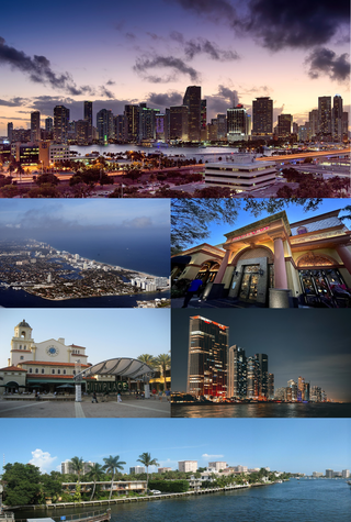
Miami-Dade County is a county located in the southeastern part of the U.S. state of Florida. The county had a population of 2,701,767 as of the 2020 census, making it the most populous county in Florida and the seventh-most populous county in the United States. It is Florida's third largest county in terms of land area with 1,946 square miles (5,040 km2). The county seat is Miami, the core of the nation's ninth-largest and world's 65th-largest metropolitan area with a 2020 population of 6.138 million people, exceeding the population of 31 of the nation's 50 states as of 2022.

Florida's 26th congressional district is an electoral district for the U.S. Congress, which was first created in South Florida in 2013 as a result of Florida's population gain in the 2010 census. In the 2020 redistricting cycle, it was drawn as a successor to the previous 25th district and includes most of inland Collier County as well as the northwestern suburbs of Miami, including Doral, Hialeah, Miami Lakes, and some neighborhoods in Miami itself, such as Allapattah and Wynwood. The previous iteration of the 26th district, which included Monroe County and the southwestern suburbs of Miami, was instead renamed as the newly-created 28th district.

Florida's 27th congressional district is an electoral district for the U.S. Congress and was first created in South Florida during 2012, effective January 2013, as a result of the 2010 census. The first candidates ran in the 2012 House elections, and the winner was seated for the 113th Congress on January 3, 2013.


