
Okeechobee County Airport is a general aviation airport located 3 mi (4.82 km) northwest of Okeechobee, in Okeechobee County, Florida.

Chatham Municipal Airport is a public airport located two miles (3 km) northwest of the central business district of Chatham, a town in Barnstable County, Massachusetts, United States. The airport is owned by the Town of Chatham.

Winona Municipal Airport is located three miles northwest of Winona, Minnesota and next to Goodview on the Mississippi River, in Winona County, Minnesota. It has no scheduled airline flights.

Florence Municipal Airport, is a public airport located in the city of Florence in Lane County, Oregon, United States. It is mostly used for general aviation.
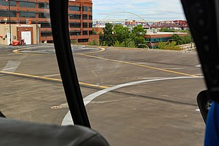
Portland Downtown Heliport is a public heliport located in the Old Town Chinatown neighborhood in the northwest section of the city of Portland, Multnomah County, Oregon, United States. It occupies the roof of a 1989 parking garage located at the intersection of NW Naito Parkway and NW Davis Street, not far from the Steel Bridge over the Willamette River.
Chuathbaluk Airport is a state-owned public-use airport located one nautical mile (1.85 km) northeast of the central business district of Chuathbaluk, a city in the Bethel Census Area of the U.S. state of Alaska.
Koyuk Alfred Adams Airport is a state-owned public-use airport located in Koyuk, a city in the Nome Census Area of the U.S. state of Alaska.

Beaver County Airport or is a county-owned public airport three miles northwest of Beaver Falls, in Beaver County, Pennsylvania.
Lakehill Airport, is a privately owned airport near Mars, Pennsylvania, U.S., part of the Pittsburgh metropolitan area. It is the smallest of the three airports located in Butler County. The other two are the Butler County Airport, and the Butler Farm Show Airport.
St. Louis Metro-East Airport, also known as Shafer Field, is a private use airport located two miles (3 km) north of the central business district of St. Jacob, in Madison County, Illinois, United States. It is privately owned by Edward B. Shafer.
Shungnak Airport is a state-owned public-use airport located in Shungnak, a city in the Northwest Arctic of the U.S. state of Alaska.
Savoonga Airport is a state-owned public-use airport located two nautical miles (4 km) south of the central business district of Savoonga, a city in the Nome Census Area of the U.S. state of Alaska. Savoonga is located on St. Lawrence Island in the Bering Sea.

Kotlik Airport is a state-owned public-use airport located one nautical mile (1.85 km) west of the central business district of Kotlik, a city in the Kusilvak Census Area of the U.S. state of Alaska.

Ridge Landing Airpark, also known as Ridge Landing Airport, is a private use airpark located four nautical miles west of the central business district of Frostproof, Florida, United States. The airpark is located between Orlando and Tampa and equidistant to Miami and Jacksonville. It is privately owned by John Fazzini.
Mekoryuk Airport is a state-owned public-use airport located three nautical miles (5.5 km) west of the central business district of Mekoryuk, a city in the Bethel Census Area, on Nunivak Island, of the U.S. state of Alaska. Airport operations began in October 1960.

Port Alsworth Airport is a private-use airport serving Port Alsworth which is located in the Lake and Peninsula Borough of the U.S. state of Alaska. As per Federal Aviation Administration records, the airport had 2,634 passenger boardings (enplanements) in calendar year 2019, an increase of 52.87% from the 1,723 enplanements in 2018.
Moundville Airport is a privately owned, public-use airport in Hale County, Alabama, United States. It is located two nautical miles south of the central business district of Moundville, Alabama.
Naukati Bay Seaplane Base, formerly known as Nichin Cove Seaplane Base, is a public use seaplane base located at Nichin Cove on the east side of Tuxekan Island, in the Prince of Wales-Hyder Census Area of the U.S. state of Alaska. It is owned by the Naukati Bay Community and located 2 nautical miles (4 km) southwest of Naukati Bay which is on Prince of Wales Island.

Kearney Air Force Base is a former United States Army Air Forces and United States Air Force base located near Kearney, Nebraska. It was in operation from 1942 through 1949, after which it was decommissioned and turned over for civilian use as Kearney Regional Airport.
