Macau is a Special Administrative Region on the southern coast of China. It is located at the south of Guangdong Province, on the tip of the peninsula formed by the Zhujiang estuary on the east and the Xijiang on the west. Macau is situated 60 km (37 mi) west of Hong Kong, and 145 km (90 mi) southwest of Guangzhou, the capital of Guangdong Province. It is situated immediately east and south of Zhuhai.

The Second Opium War, also known as the Second Anglo-Sino War, the Second China War, the Arrow War, or the Anglo-French expedition to China, was a colonial war lasting from 1856 to 1860, which pitted the British Empire and the French Empire against the Qing dynasty of China.

An artificial island is an island that has been constructed by people rather than formed by natural means. Artificial islands may vary in size from small islets reclaimed solely to support a single pillar of a building or structure to those that support entire communities and cities. Early artificial islands included floating structures in still waters or wooden or megalithic structures erected in shallow waters.

Tung Chung, meaning "eastern stream", is an area on the northwestern coast of Lantau Island, Hong Kong. One of the most recent new towns, it was formerly a rural fishing village beside Tung Chung Bay, and along the delta and lower courses of Tung Chung River and Ma Wan Chung in the north-western coast of Lantau Island. The area was once an important defence stronghold against pirates and foreign military during the Ming and the Qing dynasties.
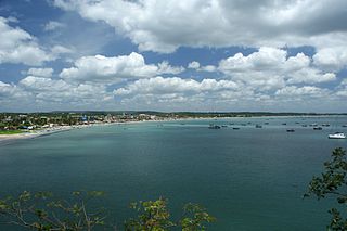
Trincomalee, also known as Gokanna and Gokarna, is the administrative headquarters of the Trincomalee District and major resort port city of Eastern Province, Sri Lanka. Located on the east coast of the island overlooking the Trincomalee Harbour, 237 kilometres (147 mi) north-east of Colombo, 182 kilometres (113 mi) south-east of Jaffna and 111 kilometres (69 mi) miles north of Batticaloa, Trincomalee has been one of the main centres of Sri Lankan Tamil language speaking culture on the island for over two millennia. With a population of 99,135, the city is built on a peninsula of the same name, which divides its inner and outer harbours. People from Trincomalee are known as Trincomalians and the local authority is Trincomalee Urban Council. Trincomalee city is home to the famous Koneswaram temple from where it developed and earned its historic Tamil name Thirukonamalai. The town is home to other historical monuments such as the Bhadrakali Amman Temple, Trincomalee, the Trincomalee Hindu Cultural Hall and, opened in 1897, the Trincomalee Hindu College. Trincomalee is also the site of the Trincomalee railway station and an ancient ferry service to Jaffna and the south side of the harbour at Muttur.

Land reclamation, usually known as reclamation, and also known as land fill, is the process of creating new land from oceans, seas, riverbeds or lake beds. The land reclaimed is known as reclamation ground or land fill.

Shamian is a sandbank island in the Liwan District of Guangzhou, Guangdong, China. The island's name literally means "sandy surface" in Chinese.

Hoi Sham Island, also called To Kwa Wan Island (土瓜灣島), was an island in Kowloon Bay off the coast of To Kwa Wan, Kowloon Peninsula in Hong Kong. It was connected to the mainland as a consequence of land reclamation, and it is now part of Hoi Sham Park (海心公園).
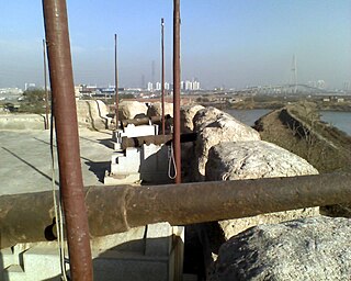
The Taku Forts or Dagu Forts, also called the Peiho Forts are forts located by the Hai River estuary in the Binhai New Area, Tianjin, in northeastern China. They are located 60 km (37 mi) southeast of the Tianjin urban center.
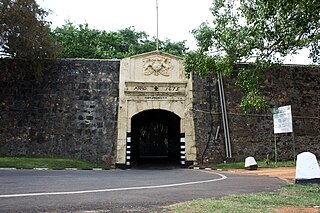
Fort Fredrick, also known as Trincomalee Fort or Fort of Triquillimale, is a fort built by the Portuguese at Trincomalee, Eastern Province, Sri Lanka, completed in 1624 CE, built on Swami Rock-Konamamalai from the debris of the world-famous ancient Hindu Koneswaram temple. The temple was destroyed by the Portuguese colonial Constantino de Sá de Noronha under Phillip III, occupier of the Jaffna kingdom and Malabar country on the island. On the Konamalai cape was also built a new village of Portuguese and Tamil people, 50 Portuguese soldiers and inside the fort, a church named after "Nossa Senhora de Guadalupe". The Fort of Triquillimale was dismantled and rebuilt by the Dutch in 1665, renamed Fort Fredrick.

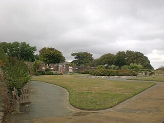
Parc Monceau is a public park situated in the 8th arrondissement of Paris, France, at the junction of Boulevard de Courcelles, Rue de Prony and Rue Georges Berger. At the main entrance is a rotunda. The park covers an area of 8.2 hectares.

The Palmerston Forts are a group of forts and associated structures around the coasts of the United Kingdom and Ireland.
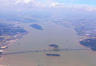
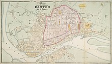
The Humen, also Bocca Tigris or Bogue, is a narrow strait in the Pearl River Delta that separates Shiziyang in the north and Lingdingyang in the south near Humen Town in China's Guangdong Province. It is the site of the Pearl River's discharge into the South China Sea. It contains the Port of Humen at Humen Town. The strait is formed by the islands of Chuenpi and Anunghoy on the eastern side, and Taikoktow on the western side. Since 1997, the strait has been traversed by the Humen Pearl River Bridge. Bocca Tigris was the entry to China's only trading city, Kanton.

Beira Lake is a lake in the centre of the city of Colombo in Sri Lanka. The lake is surrounded by many large businesses in the city. It initially occupied approximately 1.65 km2 (0.64 sq mi) of land 100 years ago and this has since been reduced to 0.65 km2 (0.25 sq mi) today due to various reasons. During the colonial era of the Portuguese, Dutch and the English the lake was used for a wide variety of purposes. It still retains its Portuguese name. It is connected to many intricate canals which provided an easy way of transporting goods within the city and suburban cities.

Fort Beversreede was a Dutch-built palisaded factorij located near the confluence of the Schuylkill River and the Delaware River. It was an outpost of the colony of New Netherland, which was centered on its capital, New Amsterdam (Manhattan), on the North River.

Stone Nullah Lane is a one-way street in Wan Chai, Hong Kong Island, Hong Kong. Named after the water channel that until 1959 ran down its middle, it stretches from Lung On Street to Queen's Road East. The street is noted for its historical landmarks, most notably the Blue House and Wan Chai Pak Tai Temple.
Sandown Barrack Battery is a battery located in Sandown Bay close to Sandown on the Isle of Wight in England. It is one of the many Palmerston Forts built on the island to protect it in response to a perceived French invasion.

Coastal defenceand coastal fortification are measures taken to provide protection against military attack at or near a coastline, for example, fortifications and coastal artillery. Because an invading enemy normally requires a port or harbour to sustain operations, such defences are usually concentrated around such facilities, or places where such facilities could be constructed. Coastal artillery fortifications generally followed the development of land fortifications, usually incorporating land defences; sometimes separate land defence forts were built to protect coastal forts. Through the middle 19th century, coastal forts could be bastion forts, star forts, polygonal forts, or sea forts, the first three types often with detached gun batteries called "water batteries". Coastal defence weapons throughout history were heavy naval guns or weapons based on them, often supplemented by lighter weapons. In the late 19th century separate batteries of coastal artillery replaced forts in some countries; in some areas these became widely separated geographically through the mid-20th century as weapon ranges increased. The amount of landward defence provided began to vary by country from the late 19th century; by 1900 new US forts almost totally neglected these defences. Booms were also usually part of a protected harbor's defences. In the middle 19th century underwater minefields and later controlled mines were often used, or stored in peacetime to be available in wartime. With the rise of the submarine threat at the beginning of the 20th century, anti-submarine nets were used extensively, usually added to boom defences, with major warships often being equipped with them through early World War I. In World War I railway artillery emerged and soon became part of coastal artillery in some countries; with railway artillery in coast defence some type of revolving mount had to be provided to allow tracking of fast-moving targets.

Land reclamation in the Netherlands has a long history. As early as in the 14th century, the first reclaimed land had been settled. Much of the modern land reclamation has been done as a part of the Zuiderzee Works since 1918.