
Surrey is a city in British Columbia, Canada. It is located south of the Fraser River on the Canada–United States border. It is a member municipality of the Metro Vancouver regional district and metropolitan area. Mainly a suburban city, Surrey is the province's second-largest by population after Vancouver and the third-largest by area after Abbotsford and Prince George. Seven neighbourhoods in Surrey are designated town centres: Cloverdale, Fleetwood, Guildford, Newton, South Surrey, and City Centre encompassed by Whalley.

The Fraser Valley is a geographical region in southwestern British Columbia, Canada and northwestern Washington State. It starts just west of Hope in a narrow valley encompassing the Fraser River and ends at the Pacific Ocean stretching from the North Shore Mountains, opposite the city of Vancouver BC, to just south of Bellingham, Washington.

The Township of Langley is a district municipality immediately east of the City of Surrey in southwestern British Columbia, Canada. It extends south from the Fraser River to the Canada–United States border, and west of the City of Abbotsford. Langley Township is not to be confused with the City of Langley, which is adjacent to the township but politically is a separate entity. Langley is located in the eastern part of Metro Vancouver.

Chilliwack is a city in the province of British Columbia, Canada. Chilliwack is surrounded by mountains and home to recreational areas such as Cultus Lake and Chilliwack Lake Provincial Parks. There are numerous outdoor activities in the area in which to participate, including hiking, rock climbing, mountain biking horseback riding, whitewater kayaking, camping, fishing, golf, and paragliding. Chilliwack is known for its annual corn harvest, and is home to the Province's second largest independent bookstore The Book Man. The Fraser Valley Regional District is headquartered in Chilliwack, which is the Fraser Valley's second-largest city, after Abbotsford.

Mission is a city in the Lower Mainland of the province of British Columbia, Canada. It was originally incorporated as a district municipality in 1892, growing to include additional villages and rural areas over the years, adding the original Town of Mission City, long an independent core of the region, in 1969. It is bordered by the city of Abbotsford to the south and the city of Maple Ridge to the west. To the east are the unincorporated areas of Hatzic and Dewdney.
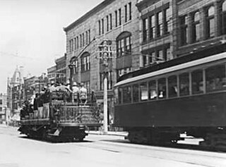
The British Columbia Electric Railway (BCER) was an historic railway which operated in southwestern British Columbia, Canada. Originally the parent company for, and later a division of, BC Electric Company, the BCER assumed control of existing streetcar and interurban lines in southwestern British Columbia in 1897, and operated the electric railway systems in the region until the last interurban service was discontinued in 1958. During and after the streetcar era, BC Electric also ran bus and trolleybus systems in Greater Vancouver and bus service in Greater Victoria; these systems subsequently became part of BC Transit, and the routes in Greater Vancouver eventually came under the control of TransLink. Trolley buses still run in the City of Vancouver with one line extending into Burnaby.

The Okanagan, also called the Okanagan Valley and sometimes the Okanagan Country, is a region in the Canadian province of British Columbia defined by the basin of Okanagan Lake and the Canadian portion of the Okanagan River. It is part of the Okanagan Country, extending into the United States as Okanogan County in north-central Washington. According to the 2016 Canadian census, the region's population is 362,258. The largest populated cities are Kelowna, Penticton, Vernon, and West Kelowna.

Hope is a district municipality at the confluence of the Fraser and Coquihalla rivers in the province of British Columbia, Canada. Hope is at the eastern end of both the Fraser Valley and the Lower Mainland region, and is at the southern end of the Fraser Canyon. To the east, over the Cascade Mountains, is the Interior region, beginning with the Similkameen Country on the farther side of the Allison Pass in Manning Park. Located 154 kilometres (96 mi) east of Vancouver, Hope is at the southern terminus of the Coquihalla Highway and the western terminus of the Crowsnest Highway, locally known as the Hope-Princeton, where they merge with the Trans-Canada Highway. Hope is at the eastern terminus of Highway 7. As it lies at the eastern end of the Fraser Valley in the windward Cascade foothills, the town gets very high amounts of rain and cloud cover – particularly throughout the autumn and winter.

The City of Langley, commonly referred to as Langley City, or just Langley, is a municipality in the Metro Vancouver Regional District in British Columbia, Canada. It lies directly east of Surrey, adjacent to the Cloverdale area, and is surrounded elsewhere by the Township of Langley, bordered by its neighbourhoods of Willowbrook to the north, Murrayville to the east, and Brookswood and Fern Ridge to the south.

Fort Langley is a village community in Township of Langley, British Columbia, Canada. It has a population of approximately 3,400 people. It is the home of Fort Langley National Historic Site, a former fur trade post of the Hudson's Bay Company. Lying on the Fraser River, Fort Langley is at the northern edge of the Township of Langley.
Walnut Grove is a town centre located within the Township of Langley, British Columbia.

Fraser Highway is a 38-kilometre-long (24 mi) major arterial road in the Lower Mainland of British Columbia. Connecting the cities of Surrey and Abbotsford, the highway formerly constituted a major portion of British Columbia Highway 1A until the latter was decommissioned in 2006. The highway is named for the Fraser River and the Fraser Valley, which are in turn named for the explorer Simon Fraser.
Aldergrove is a community in the Township of Langley within British Columbia, Canada, approximately 59 km (37 mi) east of Vancouver. The community is urban in nature and, although not incorporated as a town, is often referred to as one. Aldergrove is located at the southeastern edge of both the Township of Langley and the Greater Vancouver metropolitan area, near the western edge of the Abbotsford metropolitan area. It is home to the Lynden–Aldergrove Border Crossing, one of the Lower Mainland's five land border crossings, connecting it with Lynden, Washington.
McMillan Island is an island in the Fraser River, British Columbia, Canada, also known as McMillan Slough..
Albion, British Columbia is a neighbourhood in Maple Ridge, British Columbia and is one of several small towns incorporated within the municipality at its creation. It is the oldest non-indigenous community of the district's settlements, and is only slightly younger than Fort Langley, adjacent across the Fraser River, and Kanaka Creek, which is just to the west and lies along the creek of the same name. Its official definition is the area bounded by the Fraser River, Kanaka Way, and 240th Street, but in its historic sense it means the community centred on and flanking 240th Street and adjoining areas along the Fraser River waterfront and around the Maple Ridge Fairgrounds, while along Kanaka Way and also on the near bank of Kanaka Creek, the creek, is historically the community of Kanaka Creek. Burgeoning newer home construction east of 240th Street near the Lougheed Highway is also often referred to as part of Albion.
Mount Lehman or Mt. Lehman is a small rural community located in the Fraser Valley of south western British Columbia, Canada. The community was established in 1874 and became part of the District of Matsqui in 1892. The District of Matsqui was incorporated into the present day City of Abbotsford, British Columbia in 1995.
Port Kells is a neighborhood of Guildford, a town center in Surrey, British Columbia. The neighborhood is located in the northeastern sector of Guildford, and is adjacent to the Fraser River and west of Walnut Grove, Langley. It has two major components: a large rural southern portion located south of Highway 1, and a section north of the highway that consists mostly of industrial parks.

The Old Yale Road is a historic early wagon road between New Westminster, British Columbia, Canada and Yale, British Columbia, and servicing the Fraser Valley of the British Columbia Lower Mainland in the late 19th century and into the early 20th. It eventually became an early highway route for automobiles through the valley and into the British Columbia interior beyond Yale. It would eventually be part of, then surpassed by, the Fraser Highway, the Trans-Canada Highway and the Highway 1.
Glover Road is a primary road in Langley, British Columbia which runs from southwest to northeast North-South from the Fraser Highway in downtown Langley to the Fraser River in Fort Langley, travelling over British Columbia Highway 1 and through the community of Milner, British Columbia. The road is 11 km (7 mi) in length and mostly two lanes wide with some divided four lane sections. It is notable as the primary road in and to the village of Fort Langley and as being concurrent for some of its length with British Columbia Highway 10. Beyond Fort Langley, it crosses the Jacob Haldi Bridge onto McMillan Island and terminates at the decommissioned Albion Ferry dock within the lands of the Kwantlen First Nation. The Glover Road overpass is a six-span, two-lane structure permitting access across Trans-Canada Highway. The underpass received an overheight-warning system, the second in the province, following damage from three collisions in three years.
