
List of how many forests and percentage of forest cover in India by state.
List of how many forests and percentage of forest cover in India by state.
Tree density is the quantification of how closely the trees are growing in a hectare area. It is not the exact number of trees in the forest but, serves as an estimate to the foresters. [1] .The tree density of an area should be mentioned by the working Plan officer (WPO) or Divisional Forest Officer (Working Plan) after his field inspection of the lowest possible forest unit or compartment in the CH-4 form of compartment history. The compartment history forms are to be maintained at the Forest range and Forest division offices. The working Plan code-2014 mentions in para 105 that the density should also be mentioned on the stock map prepared by the WPO/DFO in decimal figures. The crown density is similar to the tree density. A forest area with a density of more than 0.4 is considered a good forest area and a forest area with less than 0.4 tree density is considered degraded forest.
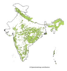
Forest cover is the total geographical area declared as forest by the government. As of 2021, the total forest cover in India is 80.9 million hectares, which is 21.71 per cent of the total geographical area. [2] There is a 1,540 sq.km increase in forest cover over 2019. Madhya Pradesh has the highest forest cover by area followed by Arunachal Pradesh. Mizoram has the highest forest cover in terms of percentage of total geographical area.
Ministry of the Environment, Forest and Climate Change used the mid-resolution satellite data on LISS-III data from Indian remote sensing satellite. Minister of environment forest and climate change Bhupendra Yadav released the Indian forest survey report 2021-22 on 13 January 2022.
As per the report, 17 Indian states have a forest cover of over 33%.
| Year | Total forest area (in sq km) | % of forested area | %change |
|---|---|---|---|
| 2021 [2] | 713,789 | 21.71% | |
| 2019 [3] | 712,249 | 21.67% | |
| 2017 [4] | 708,273 | 21.54% | |
| 2015 [5] | 701,673 | 21.34% | |
| 2013 [6] | 697,898 | 21.23% | |
| 2011 [7] | 692,027 | 21.05% |

The forest cover in 2021 in India by state and union territory as published by the Forest Survey of India (FSI) is shown in the table below. [2]
Very Dense= All lands with tree canopy density of 70 percent ( 0.7 tree density) and above.
Moderately Dense= All lands with tree canopy density of 40 percent and more but less than 70 percent ( 0.4 to 0.7 tree density).
Open Forest= All lands with tree canopy density of 10 percent and more but less than 40 percent (0.1 to 0.4 tree density). (Area in square kilometers)
| State / UT | Zone | Geographical Area | Very dense | Moderately dense | Open forest | Total forest area | % of the forested area | % change since 2019 |
|---|---|---|---|---|---|---|---|---|
| Andhra Pradesh | Southern | 162,968 | 1,994 | 13,929 | 13,861 | 29,784 | 18.28% | 2.22% |
| Arunachal Pradesh | North Eastern | 83,743 | 21,058 | 30,176 | 15,197 | 66,431 | 79.33% | -0.39% |
| Assam | North Eastern | 78,438 | 3,017 | 9,991 | 15,304 | 28,312 | 36.09% | -0.05% |
| Bihar | Eastern | 94,163 | 333 | 3,286 | 3,762 | 7,381 | 7.84% | 1.03% |
| Chhattisgarh | Central | 135,192 | 7,068 | 32,279 | 16,370 | 55,717 | 41.21% | 0.19% |
| Delhi | Northern | 1,483 | 6.72 | 56.6 | 131.68 | 195 | 13.15% | -0.23% |
| Goa | Western | 3,702 | 538 | 576 | 1,130 | 2,244 | 60.62% | 0.31% |
| Gujarat | Western | 196,244 | 378 | 5,032 | 9,516 | 14,926 | 7.61% | 0.46% |
| Haryana | Northern | 44,212 | 28 | 445 | 1,130 | 1,603 | 3.63% | 0.06% |
| Himachal Pradesh | Northern | 55,673 | 3,163 | 7,100 | 5,180 | 15,443 | 27.73% | 0.06% |
| Jharkhand | Eastern | 79,716 | 2,601 | 9,689 | 11,431 | 23,721 | 29.76% | 0.47% |
| Karnataka | Southern | 191,791 | 4,533 | 20,985 | 13,212 | 38,730 | 20.19% | 0.4% |
| Kerala | Southern | 38,852 | 1,944 | 9,472 | 9,837 | 21,253 | 54.7% | 0.52% |
| Madhya Pradesh | Central | 308,252 | 6,665 | 34,209 | 36,619 | 77,493 | 25.14% | 0.01% |
| Maharashtra | Western | 307,713 | 8,734 | 20,589 | 21,475 | 50,798 | 16.51% | 0.04% |
| Manipur | North Eastern | 22,327 | 905 | 6,228 | 9,465 | 16,598 | 74.34% | -1.48% |
| Meghalaya | North Eastern | 22,429 | 560 | 9,160 | 7,326 | 17,046 | 76% | -0.43% |
| Mizoram | North Eastern | 21,081 | 157 | 5,715 | 11,948 | 17,820 | 84.53% | -1.03% |
| Nagaland | North Eastern | 16,579 | 1,272 | 4,449 | 6,530 | 12,251 | 73.9% | -1.88% |
| Odisha | Eastern | 155,707 | 7,213 | 20,995 | 23,948 | 52,156 | 33.5% | 1.04% |
| Punjab | Northern | 50,362 | 11 | 793 | 1,043 | 1,847 | 3.67% | -0.11% |
| Rajasthan | Northern | 342,239 | 78 | 4,369 | 12,208 | 16,655 | 4.87% | 0.15% |
| Sikkim | North Eastern | 7,096 | 1,102 | 1,551 | 688 | 3,341 | 47.08% | -0.03% |
| Tamil Nadu | Southern | 130,060 | 3,593 | 11,034 | 11,792 | 26,419 | 20.31% | 0.21% |
| Telangana | Southern | 112,077 | 1,624 | 9,119 | 10,471 | 21,214 | 18.93% | 3.07% |
| Tripura | North Eastern | 10,486 | 647 | 5,212 | 1,863 | 7,722 | 73.64% | -0.05% |
| Uttar Pradesh | Central | 240,928 | 2,627 | 4,029 | 8,162 | 14,818 | 6.15% | 0.08% |
| Uttarakhand | Central | 53,483 | 5,055 | 12,768 | 6,482 | 24,305 | 45.44% | 0.01% |
| West Bengal | Eastern | 88,752 | 3,037 | 4,208 | 9,587 | 16,832 | 18.96% | -0.41% |
| A & N Islands | Southern | 8,249 | 5,678 | 683 | 383 | 6,744 | 81.75% | 0.01% |
| Chandigarh | Northern | 114 | 1.36 | 13.51 | 8.01 | 22.88 | 20.07% | 3.86% |
| Dadra and Nagar Haveli and Daman and Diu | Western | 602 | 1.4 | 85.56 | 140.79 | 227.75 | 37.83% | 0.04% |
| Jammu and Kashmir | Northern | 54,624 | 4,155 | 8,117 | 9,115 | 21,387 | 39.15% | 0.14% |
| Ladakh | Northern | 168,055 | 2 | 512 | 1,758 | 2,272 | 1.35% | 0.8% |
| Lakshadweep | Southern | 30 | 0 | 16.09 | 11.01 | 27.1 | 90.33% | 0% |
| Puducherry | Southern | 490 | 0 | 17.53 | 35.77 | 53.3 | 10.88% | 1.7% |
| Total | 3,287,469 | 99,779 | 306,890 | 307,120 | 713,789 | 24.45% | 0.22% |
The forest cover in 2017 in India by state and union territory as published by the Forest Survey of India (FSI) is shown in the table below. [8] [9]
Very Dense= All lands with tree canopy density of 70 percent ( 0.7 tree density) and above.
Moderately Dense= All lands with tree canopy density of 40 percent and more but less than 70 percent ( 0.4 to 0.7 tree density).
Open Forest= All lands with tree canopy density of 10 percent and more but less than 40 percent (0.1 to 0.4 tree density).
Scrub= All forest lands with poor tree growth mainly of small or stunted trees canopy density less than 10 percent (Less than 0.1 tree density).
(Area in square kilometers)
| State / UT | Geographical Area | Very dense | Moderately dense | Open forest | Total forest area | % of forested area | % change since 2015 |
|---|---|---|---|---|---|---|---|
| Andhra Pradesh | 162,968 | 1,957 | 14,051 | 12,139 | 28,147 | 17.27% | +1.31% |
| Arunachal Pradesh | 83,743 | 20,721 | 30,955 | 15,288 | 66,964 | 79.96% | -0.23% |
| Assam | 78,438 | 2,797 | 10,192 | 15,116 | 28,105 | 35.83% | +0.72% |
| Bihar | 94,163 | 332 | 3,260 | 3,707 | 7,299 | 7.75% | +0.05% |
| Chhattisgarh | 135,192 | 7,064 | 32,215 | 16,268 | 55,547 | 41.09% | -0.01% |
| Delhi | 1,483 | 7 | 56 | 129 | 192 | 20.6% | +0.25% |
| Goa | 3,702 | 538 | 576 | 1,115 | 2,229 | 60.21% | +0.51% |
| Gujarat | 196,244 | 378 | 5,200 | 9,179 | 14,757 | 7.52% | +0.02% |
| Haryana | 44,212 | 28 | 452 | 1,108 | 1,588 | 3.59% | +0.02% |
| Himachal Pradesh | 55,673 | 3,110 | 6,705 | 5,285 | 15,100 | 27.12% | +0.71% |
| Jammu & Kashmir | 222,236 | 4,075 | 8,579 | 10,587 | 23,241 | 10.46% | +0.11% |
| Jharkhand | 79,716 | 2,598 | 9,686 | 11,269 | 23,553 | 29.55% | +0.04% |
| Karnataka | 191,791 | 4,502 | 20,444 | 12,604 | 37,550 | 19.58% | +0.57% |
| Kerala | 38,852 | 1,663 | 9,407 | 8,251 | 20,321 | 52.30% | +2.68% |
| Madhya Pradesh | 308,252 | 6,563 | 34,571 | 36,280 | 77,414 | 25.11% | -0.00% |
| Maharashtra | 307,713 | 8,736 | 20,652 | 21,294 | 50,682 | 16.47% | -0.01% |
| Manipur | 22,327 | 908 | 6,510 | 9,928 | 17,346 | 77.69% | +1.18% |
| Meghalaya | 22,429 | 453 | 9,386 | 7,307 | 17,146 | 76.76% | -0.52% |
| Mizoram | 21,081 | 131 | 5,861 | 12,194 | 18,186 | 86.27% | -2.52% |
| Nagaland | 16,579 | 1,279 | 4,587 | 6,623 | 12,489 | 75.33% | -2.71% |
| Odisha | 155,707 | 6,967 | 21,370 | 23,008 | 51,345 | 32.98% | +0.57% |
| Punjab | 50,362 | 8 | 806 | 1,023 | 1,837 | 3.65% | +0.13% |
| Rajasthan | 342,239 | 78 | 4,340 | 12,154 | 16,572 | 4.84% | +0.14% |
| Sikkim | 7,096 | 1,081 | 1,575 | 688 | 3,344 | 47.13% | -0.13% |
| Tamil Nadu | 130,060 | 3,672 | 10,979 | 11,630 | 26,281 | 20.21% | +0.06% |
| Telangana | 112,077 | 1,596 | 8,738 | 10,085 | 26969 | 18.22% | +0.50% |
| Tripura | 10,486 | 656 | 5,246 | 1,824 | 7,726 | 73.68% | -1.56% |
| Uttar Pradesh | 240,928 | 2,617 | 4,069 | 7,993 | 14,679 | 6.09% | +0.12% |
| Uttarakhand | 53,483 | 4,969 | 12,884 | 6,442 | 24,295 | 45.43% | +0.04% |
| West Bengal | 88,752 | 2,994 | 4,147 | 9,706 | 16,847 | 18.98% | +0.02% |
| Andaman & Nicobar Islands | 8,249 | 5,678 | 684 | 380 | 6,742 | 81.73% | -0.11% |
| Chandigarh | 114 | 1 | 14 | 6 | 22 | 18.91% | -0.09% |
| Dadra & Nagar Haveli | 491 | 0 | 80 | 127 | 207 | 42.16% | +0.20% |
| Daman & Diu | 111 | 1 | 6 | 13 | 20 | 18.46% | +0.79% |
| Lakshadweep | 30 | 0 | 17 | 10 | 27 | 90.33% | 0.13% |
| Puducherry | 490 | 0 | 18 | 36 | 54 | 10.95% | -0.67% |
| Total | 3,287,469 | 98,158 | 308,318 | 301,797 | 708,273 | 21.54% | +0.21% |
According to Forest Survey of India (FSI), the forest cover by State/UT in India in 2015 is listed below. [8]
Very Dense= All lands with tree canopy density of 70 percent and above.
Moderately Dense= All lands with tree canopy density of 40 percent and more but less than 70 percent.
Open Forest= All lands with tree canopy density of 10 percent and more but less than 40 percent.
(Area in square kilometers)
| State / UT | Geographical Area | Very dense | Moderately dense | Open forest |
|---|---|---|---|---|
| Andhra Pradesh | 162,968 | 421 | 14,352 | 11,233 |
| Arunachal Pradesh | 83,743 | 20,806 | 31,181 | 15,167 |
| Assam | 78,438 | 1,425 | 11,256 | 14,857 |
| Bihar | 94,163 | 248 | 3,362 | 3,644 |
| Chhattisgarh | 135,192 | 7,001 | 32,305 | 16,253 |
| Delhi | 1,483 | 6.94 | 57.15 | 154.68 |
| Goa | 3,702 | 536 | 580 | 1,094 |
| Gujarat | 196,244 | 378 | 5,198 | 9,134 |
| Haryana | 44,212 | 28 | 444 | 1,108 |
| Himachal Pradesh | 55,673 | 3,225 | 6,387 | 5,095 |
| Jammu & Kashmir | 222,236 | 4,061 | 8,815 | 10,112 |
| Jharkhand | 79,716 | 2,601 | 9,692 | 11,231 |
| Karnataka | 191,791 | 1,783 | 20,177 | 14,489 |
| Kerala | 38,852 | 1,529 | 9,328 | 8,421 |
| Madhya Pradesh | 308,252 | 6,586 | 34,837 | 36,003 |
| Maharashtra | 307,713 | 8,685 | 20,792 | 21,222 |
| Manipur | 22,327 | 729 | 5,964 | 10,390 |
| Meghalaya | 22,429 | 417 | 9,555 | 7,290 |
| Mizoram | 21,081 | 135 | 5,800 | 12,782 |
| Nagaland | 16,579 | 1,284 | 4,690 | 6,965 |
| Odisha | 155,707 | 6,985 | 21,470 | 22,005 |
| Punjab | 50,362 | 0 | 733 | 1,038 |
| Rajasthan | 342,239 | 77 | 4,414 | 11,615 |
| Sikkim | 7,096 | 499 | 2,157 | 697 |
| Tamil Nadu | 130,060 | 3,005 | 10,472 | 12,731 |
| Telangana | 112,077 | 465 | 11,340 | 8,049 |
| Tripura | 10,486 | 110 | 4,699 | 3,111 |
| Uttar Pradesh | 240,928 | 2,171 | 4,043 | 8,187 |
| Uttarakhand | 53,483 | 4,804 | 13,662 | 5,806 |
| West Bengal | 88,752 | 2,943 | 4,176 | 9,707 |
| Andaman & Nicobar Islands | 8,249 | 5,686 | 685 | 380 |
| Chandigarh | 114 | 1.36 | 13.92 | 6.38 |
| Dadra & Nagar Haveli | 491 | 0 | 80 | 126 |
| Daman & Diu | 111 | 1.4 | 5.82 | 12.39 |
| Lakshadweep | 30 | 0 | 17.22 | 9.84 |
| Puducherry | 490 | 0 | 28.78 | 28.17 |
| Total | 3,287,469 | 88,633 | 312,739 | 300,123 |

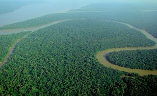
The country of Brazil occupies roughly half of South America, bordering the Atlantic Ocean. Brazil covers a total area of 8,514,215 km2 (3,287,357 sq mi) which includes 8,456,510 km2 (3,265,080 sq mi) of land and 55,455 km2 (21,411 sq mi) of water. The highest point in Brazil is Pico da Neblina at 2,994 m (9,823 ft). Brazil is bordered by the countries of Argentina, Bolivia, Colombia, Guyana, Paraguay, Peru, Suriname, Uruguay, Venezuela, and France.
A forest is an ecosystem characterized by a dense community of trees. Hundreds of definitions of forest are used throughout the world, incorporating factors such as tree density, tree height, land use, legal standing, and ecological function. The United Nations' Food and Agriculture Organization (FAO) defines a forest as, "Land spanning more than 0.5 hectares with trees higher than 5 meters and a canopy cover of more than 10 percent, or trees able to reach these thresholds in situ. It does not include land that is predominantly under agricultural or urban use." Using this definition, Global Forest Resources Assessment 2020 found that forests covered 4.06 billion hectares, or approximately 31 percent of the world's land area in 2020.
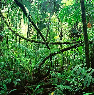
Rainforests are forests characterized by a closed and continuous tree canopy, moisture-dependent vegetation, the presence of epiphytes and lianas and the absence of wildfire. Rainforests can be generally classified as tropical rainforests or temperate rainforests, but other types have been described.

A savanna or savannah is a mixed woodland-grassland ecosystem characterised by the trees being sufficiently widely spaced so that the canopy does not close. The open canopy allows sufficient light to reach the ground to support an unbroken herbaceous layer consisting primarily of grasses. According to Britannica, there exists four savanna forms; savanna woodland where trees and shrubs form a light canopy, tree savanna with scattered trees and shrubs, shrub savanna with distributed shrubs, and grass savanna where trees and shrubs are mostly nonexistent.

Tropical and subtropical moist broadleaf forests (TSMF), also known as tropical moist forest, is a subtropical and tropical forest habitat type defined by the World Wide Fund for Nature.

The western tanager, is a medium-sized American songbird. Formerly placed in the tanager family (Thraupidae), other members of its genus and it are classified in the cardinal family (Cardinalidae). The species's plumage and vocalizations are similar to other members of the cardinal family.

Rangelands are grasslands, shrublands, woodlands, wetlands, and deserts that are grazed by domestic livestock or wild animals. Types of rangelands include tallgrass and shortgrass prairies, desert grasslands and shrublands, woodlands, savannas, chaparrals, steppes, and tundras. Rangelands do not include forests lacking grazable understory vegetation, barren desert, farmland, or land covered by solid rock, concrete and/or glaciers.

The East Deccan dry evergreen forests is an ecoregion of southeastern India. The ecoregion includes the coastal region behind the Coromandel Coast on the Bay of Bengal, between the Eastern Ghats and the sea. It covers eastern Tamil Nadu, part of Puducherry and south eastern Andhra Pradesh.

Gitagum, officially the Municipality of Gitagum, is a 5th class municipality in the province of Misamis Oriental, Philippines. The municipality is bounded on the north by Mindanao Sea, on the east by the Municipality of Laguindingan, on the south by the Municipality of Alubijid and on the west the Municipality of Libertad. It is approximately 40 km. away from Cagayan de Oro. According to the 2020 census, it has a population of 17,920 people.

Lindi Region is one of Tanzania's 31 administrative regions. The region covers an area of 66,040 km2 (25,500 sq mi). The region is comparable in size to the combined land area of the nation state of Sri Lanka. The regional capital is the municipality of Lindi.

An urban forest is a forest, or a collection of trees, that grow within a city, town or a suburb. In a wider sense, it may include any kind of woody plant vegetation growing in and around human settlements. As opposed to a forest park, whose ecosystems are also inherited from wilderness leftovers, urban forests often lack amenities like public bathrooms, paved paths, or sometimes clear borders which are distinct features of parks. Care and management of urban forests is called urban forestry. Urban forests can be privately and publicly owned. Some municipal forests may be located outside of the town or city to which they belong.

Bachman's sparrow, also known as the pinewoods sparrow or oakwoods sparrow, is a small American sparrow that is endemic to the southeastern United States. This species was named in honor of Reverend John Bachman.

Forestry in India is a significant rural industry and a major environmental resource. India is one of the ten most forest-rich countries of the world. Together, India and 9 other countries account for 67 percent of the total forest area of the world. India's forest cover grew at 0.20% annually over 1990–2000, and has grown at the rate of 0.7% per year over 2000–2010, after decades where forest degradation was a matter of serious concern.

Crown closure, in forestry, is a measure of forest canopy coverage. Crown closure and crown cover are two slightly different measures of the forest canopy and that determine the amount of light able to penetrate to the forest floor.

The Willamette Valley ecoregion is a Level III ecoregion designated by the United States Environmental Protection Agency in the U.S. states of Oregon and Washington. Slightly larger than the Willamette Valley for which it is named, the ecoregion contains fluvial terraces and floodplains of the Willamette River system, scattered hills, buttes, and adjacent foothills. It is distinguished from the neighboring Coast Range, Cascades, and Klamath Mountains ecoregions by lower precipitation, lower elevation, less relief, and a different mosaic of vegetation. Mean annual rainfall is 37 to 60 inches, and summers are generally dry. Historically, the region was covered by rolling prairies, oak savanna, coniferous forests, extensive wetlands, and deciduous riparian forests. Today, it contains the bulk of Oregon's population, industry, commerce, and agriculture. Productive soils and a temperate climate make it one of the most important agricultural areas in Oregon.

Odisha, a state in eastern India, is extremely diverse and gives the state abundance of natural beauty and wildlife. The districts in the interior are thickly covered by tropical moist deciduous and tropical dry deciduous forests. The hills, plateaus and isolated areas of the northeastern part of the state are covered by the tropical moist deciduous forests whereas the dry deciduous forests are located in the southwest region of the state. Some of the trees which grow in abundance in Odisha are bamboo, teak, rosewood, sal, piasal, sanghvan and haldi. There are 479 species of birds, 86 species of mammals, 19 species of amphibians and 110 species of reptiles present in Odisha. The state is also an important habitat for the endangered olive ridley turtles and Irrawaddy dolphins. Koraput district of southern Odisha has been identified by Food and Agriculture Organisation (FAO) of UN as Global Agricultural Heritage site which is among only other three sites in the world. Other sites are in Peru, China and Philippines.

The Sri Lanka lowland rain forests represents Sri Lanka's Tropical rainforests below 1,000 m (3,281 ft) in elevation in the southwestern part of the island. The year-around warm, wet climate together with thousands years of isolation from mainland India have resulted in the evolution of numerous plants and animal species that can only be found in rain forests in Sri Lanka. The thick forest canopy is made up of over 150 species of trees, some of the emergent layer reaching as high as 45 m (148 ft). The lowland rain forests accounts for 2.14 percent of Sri Lanka's land area. This ecoregion is the home of the jungle shrew, a small endemic mammal of Sri Lanka. Sri Lanka has the highest density of amphibian species worldwide. Many of these, including 250 species of tree frogs, live in these rain forests.

Conservation in India can be traced to the time of Ashoka, tracing to the Ashoka Pillar Edicts as one of the earliest conservation efforts in the world. Conservation generally refers to the act of carefully and efficiently using natural resources. Conservation efforts begun in India before 5 AD, as efforts are made to have a forest administration. The Ministry of Environment, Forest and Climate Change is the ministry responsible for implementation of environmental and forestry program in India, which include the management of national parks, conservation of flora and fauna of India, and pollution controls.
Forest cover is the amount of forest that covers a particular area of land. It may be measured as relative or absolute. Nearly a third of the world's land surface is covered with forest, with closed-canopy forest accounting for 4 - 5 billion hectares of land. Forests provide many ecosystem services that humans and animals cannot survive without, but anthropogenic actions and climate change are threatening global forest cover in potentially irreversible ways.
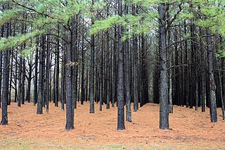
A tree plantation, forest plantation, plantation forest, timber plantation or tree farm is a forest planted for high volume production of wood, usually by planting one type of tree as a monoculture forest. The term tree farm also is used to refer to tree nurseries and Christmas tree farms.