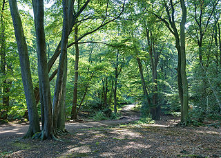
Epping Forest is a 2,400-hectare (5,900-acre) area of ancient woodland, and other established habitats, which straddles the border between Greater London and Essex. The main body of the forest stretches from Epping in the north, to Chingford on the edge of the London built-up area. South of Chingford the forest narrows, and forms a green corridor that extends deep into East London, as far as Forest Gate; the Forest's position gives rise to its nickname, the Cockney Paradise.

The village and civil parish of Writtle lies 1 mile (1.6 km) west of Chelmsford, Essex, England. It has a traditional village green complete with duck pond and a Norman church, and was once described as "one of the loveliest villages in England, with a ravishing variety of ancient cottages". The village is now home to Writtle College, one of the UK's oldest and largest land-based colleges and a partner institution of the University of Essex, the grounds of which once housed a Royal hunting lodge, later the possession of the De Brus and De Bohun families.

In the United Kingdom, an ancient woodland is a woodland that has existed continuously since 1600 or before in England, Wales and Northern Ireland. Planting of woodland was uncommon before those dates, so a wood present in 1600 is likely to have developed naturally.

A royal forest, occasionally known as a kingswood, is an area of land with different definitions in England, Wales, Scotland and Ireland. The term forest in the ordinary modern understanding refers to an area of wooded land; however, the original medieval sense was closer to the modern idea of a "preserve" – i.e. land legally set aside for specific purposes such as royal hunting – with less emphasis on its composition. There are also differing and contextual interpretations in Continental Europe derived from the Carolingian and Merovingian legal systems.

Oliver Rackham was an academic at the University of Cambridge who studied the ecology, management and development of the British countryside, especially trees, woodlands and wood pasture. His books included Ancient Woodland (1980) and The History of the Countryside (1986).
Verderers are forestry officials in England who deal with common land in certain former royal hunting areas which are the property of the Crown. The office was developed in the Middle Ages to administer forest law on behalf of the King. Verderers investigated and recorded minor offences such as the taking of venison and the illegal cutting of woodland, and dealt with the day-to-day forest administration. In the modern era, verderers are still to be found in the New Forest, the Forest of Dean, and Epping Forest, where they serve to protect commoning practices, and conserve the traditional landscape and wildlife.
Purlieu is a term used of the outlying parts of a place or district. It was a term of the old Forest law, and meant, as defined by John Manwood, Treatise of the Lawes of the Forest,
a certain territory of ground adjoining unto the forest [which] was once forest-land and afterwards disafforested by the perambulations made for the severing of the new forests from the old
Leighfield is a civil parish in the county of Rutland in the East Midlands of England. There is no settlement centre in the parish, only a few isolated properties. In the 2001 census it had a population of 10, which was the fourth smallest of Rutland's parish populations. At the 2011 census the population remained less than 100 and was included in the civil parish of Ridlington. It shares its name with Leighfield Forest, a much larger area from Braunston-in-Rutland to Stockerston and from Skeffington to Ridlington, a triangle of land roughly 4 miles (6.4 km) in each direction.

Wychwood or Wychwood Forest is a 501.7-hectare (1,240-acre) biological Site of Special Scientific Interest north of Witney in Oxfordshire. It is also a Nature Conservation Review site, Grade 1, and an area of 263.4 hectares is a national nature reserve The site contains a long barrow dating to the Neolithic period, which is a scheduled monument.

Hainault Forest Country Park is a Country Park located in Greater London, with portions in: Hainault in the London Borough of Redbridge; the London Borough of Havering; and in the Lambourne parish of the Epping Forest District in Essex.

Siston is a small village in South Gloucestershire, England. It is 7 miles (11 km) east of Bristol at the confluence of the two sources of the Siston Brook, a tributary of the River Avon. The village consists of a number of cottages and farms centred on St Anne's Church, and the grand Tudor manor house of Siston Court. Anciently it was bordered to the west by the royal Hunting Forest of Kingswood, stretching westward most of the way to Bristol Castle, always a royal possession, caput of the Forest. The local part of the disafforested Kingswood became Siston Common but has recently been eroded by the construction of the Avon Ring Road and housing developments. In 1989 the village and environs were classed as a conservation area and thus have statutory protection from overdevelopment.

Hatfield Forest is a 403.2 hectare biological Site of Special Scientific Interest in Essex, three miles east of Bishop's Stortford. It is also a National Nature Reserve and a Nature Conservation Review site. It is owned and managed by the National Trust. A medieval warren in the forest is a Scheduled Monument.
The Forest of Middlesex was an ancient woodland covering much of the county of Middlesex, England, that was north of the City of London and now forms the northern part of Greater London. A path was cut through the forest for the creation of Watling Street. At its ancient extent the forest stretched twelve miles north from the city walls at Houndsditch. Following the Norman Conquest it became the royal forest of Middlesex, where citizens of the City of London enjoyed the right of free chase by charters granted by Henry I and Henry II.

In medieval and Early Modern England, Wales and Ireland, a deer park was an enclosed area containing deer. It was bounded by a ditch and bank with a wooden park pale on top of the bank, or by a stone or brick wall. The ditch was on the inside increasing the effective height. Some parks had deer "leaps", where there was an external ramp and the inner ditch was constructed on a grander scale, thus allowing deer to enter the park but preventing them from leaving.

Hatfield Broad Oak Priory, or Hatfield Regis Priory, is a former Benedictine priory in Hatfield Broad Oak, Essex, England. Founded by 1139, it was dissolved in 1536 as part of Henry VIII's dissolution of the monasteries.

Feckenham Forest was a royal forest, centred on the village of Feckenham, covering large parts of Worcestershire and west Warwickshire. It was not entirely wooded, nor entirely the property of the King. Rather, the King had legal rights over game, wood and grazing within the forest, and special courts imposed harsh penalties when these rights were violated. Courts and the forest gaol were located at Feckenham and executions took place at Gallows Green near Hanbury.
Leicester Forest was a Royal Forest that existed to the West of Leicester.

Essex is a county in the East of England. One of the home counties, it borders Suffolk and Cambridgeshire to the north, the North Sea to the east, Hertfordshire to the west, Kent across the estuary of the River Thames to the south, and Greater London to the south and south-west. The county town is Chelmsford, which is one of two cities in the county, the other being Southend-on-Sea which was granted city status on 1 March 2022. Colchester will become a city later in 2022 as part of the Queen’s Platinum Jubilee. For the purposes of government statistics, Essex is placed in the East of England region.
Waltham Forest was a royal forest that existed from around the time the Forest of Essex was disestablished in the 13th century. After that Forest Law was focused on areas with higher concentrations of woodland than the sparsely wooded Forest of Essex ever had.
