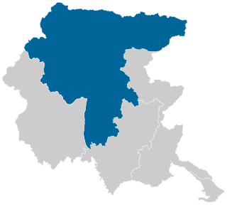
Friuli-Venezia Giulia is one of the 20 regions of Italy and one of five autonomous regions with special statute. The regional capital is Trieste on the Gulf of Trieste, a bay of the Adriatic Sea.

Friuli is a historical region of northeast Italy. The region is marked by its separate regional and ethnic identity predominantly tied to the Friulians, who traditionally spoke the Friulian language. It comprises the major part of the autonomous region Friuli-Venezia Giulia, i.e. the administrative provinces of Udine, Pordenone, and Gorizia, excluding Trieste.

The province of Udine was a province in the autonomous Friuli-Venezia Giulia region of Italy, bordering Austria and Slovenia, with the capital in the city of Udine. Abolished on 30 September 2017, it was reestablished in 2019 as the Regional decentralization entity of Udine, and was reactivated on 1 July 2020. It has a population of 530,849 inhabitants over an area of 4,907.24 square kilometres (1,894.70 sq mi).

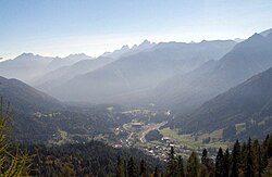
Tarvisio is a comune (municipality) in the Regional decentralization entity of Udine, in the autonomous Friuli-Venezia Giulia region of Italy.

Aviano is a town and comune (municipality) in the Regional decentralization entity of Pordenone at the foot of the Dolomites mountain range in Friuli-Venezia Giulia, northeast Italy.
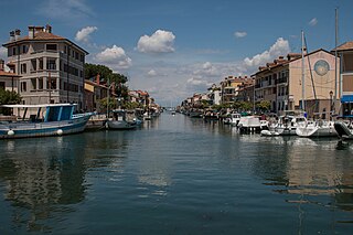
Grado is a town and comune (municipality) of 8,064 residents in the Regional decentralization entity of Gorizia in the north-eastern Italian region of Friuli-Venezia Giulia, located on an island and adjacent peninsula of the Adriatic Sea between Venice and Trieste. The territory of the municipality of Grado extends between the mouth of the Isonzo and the Adriatic Sea and the Grado Lagoon, and covers an area of about 90 square kilometers between Porto Buso and Fossalon. Characteristic of the lagoon is the presence of the casoni, which are simple houses with thatched roof used in the past by the fishermen of Grado, who remained in the lagoon for a long time, returning to the island of Grado only during the colder period of the year.

The Tagliamento is a braided river in north-east Italy, flowing from the Alps to the Adriatic Sea at a point between Trieste and Venice.

Tolmezzo is a town and comune (municipality) in the Regional decentralization entity of Udine, part of the autonomous Friuli-Venezia Giulia region of north-eastern Italy.

Sappada is a comune (municipality) in the Regional decentralization entity of Udine, in the Italian region of Friuli Venezia Giulia. It is one of I Borghi più belli d'Italia.

Fagagna is a comune (municipality) in the Regional decentralization entity of Udine in the Italian region Friuli-Venezia Giulia, located about 80 kilometres (50 mi) northwest of Trieste and about 13 kilometres (8 mi) northwest of Udine. As of 2011, it had a population of 6,279 and an area of 37.0 square kilometres (14.3 sq mi). It is one of I Borghi più belli d'Italia.

Forni di Sotto is a comune (municipality) in the Regional decentralization entity of Udine in the Italian region of Friuli Venezia Giulia, located about 120 kilometres (75 mi) northwest of Trieste and about 60 kilometres (37 mi) northwest of Udine. As of 31 December 2004, it had a population of 701 and an area of 93.0 square kilometres (35.9 sq mi).

Sauris is a comune (municipality) in the Regional decentralization entity of Udine in the Italian region of Friuli Venezia Giulia. At an elevation of 1,212 m (3,976 ft), it is the second highest municipality in the region and one of the German language islands in Northeast Italy. Sauris is part of the Alpine pearls cooperation for sustainable tourism.
Socchieve is a comune (municipality) in the Regional decentralization entity of Udine in the Italian region Friuli Venezia Giulia, located about 110 kilometres (68 mi) northwest of Trieste and about 45 kilometres (28 mi) northwest of Udine.

Claut is a comune (municipality) in the Regional decentralization entity of Pordenone in the Italian region of Friuli Venezia Giulia, located about 120 kilometres (75 mi) northwest of Trieste and about 35 kilometres (22 mi) northwest of Pordenone.
Tramonti di Sopra is a comune (municipality) in the Regional decentralization entity of Pordenone in the Italian autonomous region of Friuli Venezia Giulia, located about 110 kilometres (68 mi) northwest of Trieste and about 40 kilometres (25 mi) northeast of Pordenone.
Nassfeld Pass is a 1,530-metre-high (5,020 ft) mountain pass connecting Hermagor in the Austrian state of Carinthia with Pontebba in the Italian region of Friuli Venezia Giulia.

Carnia is a historical-geographic region in the northeastern Italian area of Friuli. Its 27 municipalities all belong to the province of Udine, which itself is part of the autonomous Friuli Venezia Giulia region.

The Rosandra Valley is a valley centered on the Rosandra River in the municipality of Dolina in the Italian region of Friuli Venezia Giulia, between the city of Trieste and the border with Slovenia. It is part of a nature park, mostly set around the Rosandra River. The surrounding hills reach an elevation of 412 metres (1,352 ft). The northern end of the valley crosses the Italian-Slovenian border. The Rosandra Valley is part of the Karst geographical region. Tourist attractions in the valley are 40-metre (130 ft) Supet Falls near the village of Botazzo and Our Lady of Siaris Church perched high in the hills of the valley.
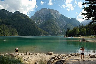
Lake Predil is a lake near Cave del Predil, part of the Tarvisio municipality in the Province of Udine, in the Italian region of Friuli Venezia Giulia.
The Codroipo electoral district was an uninominal district in Italy for the Chamber of Deputies.