Fort Atkinson, Iowa

Last updated

Fort Atkinson, Iowa
Fort Atkinson Iowa.jpg
Ruins of historic Fort Atkinson
Winneshiek County Iowa Incorporated and Unincorporated areas Fort Atkinson Highlighted.svg
Location of Fort Atkinson, Iowa
Coordinates: 43°8′39″N91°56′5″W / 43.14417°N 91.93472°W / 43.14417; -91.93472
Country United States
State Iowa
County Winneshiek
Area
[1]
  Total0.32 sq mi (0.82 km2)
  Land0.32 sq mi (0.82 km2)
  Water0.00 sq mi (0.00 km2)
Elevation
1,047 ft (319 m)
Population
 (2020)
  Total312
  Density981.13/sq mi (379.31/km2)
Time zone UTC-6 (Central (CST))
  Summer (DST) UTC-5 (CDT)
ZIP code
52144
Area code 563
FIPS code 19-28425
GNIS feature ID0456681

Fort Atkinson is a city in Winneshiek County, Iowa, United States. The population was 312 at the time of the 2020 census. [2] It is home to the historic Fort Atkinson State Preserve and hosts a large annual fur-trapper rendezvous each September. [3] Fort Atkinson holds the largest regional hay auction every Wednesday. [4]

Contents

History

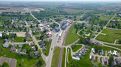
Fort Atkinson was built to protect the Ho-Chunk (Winnebago) during their removal from Wisconsin. The name honors Henry Atkinson, the commanding officer in charge of the effort. Construction began in May 1840 and was complete by the summer of 1842. The regular army turned the fort over to Iowa volunteers as the troops stationed there were needed for the Mexican–American War. After the Ho-Chunk were removed from Iowa the post was abandoned on February 14, 1849. [5]

Geography

Fort Atkinson is located at 43°8′39″N91°56′5″W / 43.14417°N 91.93472°W / 43.14417; -91.93472 (43.144034, −91.934839). [6]

According to the United States Census Bureau, the city has a total area of 0.31 square miles (0.80 km2), all land. [7]

Demographics

Historical populations
YearPop.±%
1880 435    
1890 480+10.3%
1900 264−45.0%
1910 289+9.5%
1920 315+9.0%
1930 305−3.2%
1940 261−14.4%
1950 273+4.6%
1960 353+29.3%
1970 339−4.0%
1980 374+10.3%
1990 367−1.9%
2000 389+6.0%
2010 349−10.3%
2020 312−10.6%
Source: "U.S. Census website". United States Census Bureau . Retrieved March 28, 2020. and Iowa Data Center
Source:
U.S. Decennial Census [8] [2]
The population of Fort Atkinson, Iowa from US census data Fort AtkinsonIowaPopPlot.png
The population of Fort Atkinson, Iowa from US census data

2010 census

As of the census [9] of 2010, there were 349 people, 160 households, and 102 families residing in the city. The population density was 1,125.8 inhabitants per square mile (434.7/km2). There were 170 housing units at an average density of 548.4 per square mile (211.7/km2). The racial makeup of the city was 98.0% White, 1.7% from other races, and 0.3% from two or more races. Hispanic or Latino of any race were 3.2% of the population.

There were 160 households, of which 22.5% had children under the age of 18 living with them, 46.9% were married couples living together, 11.9% had a female householder with no husband present, 5.0% had a male householder with no wife present, and 36.3% were non-families. 34.4% of all households were made up of individuals, and 20% had someone living alone who was 65 years of age or older. The average household size was 2.18 and the average family size was 2.78.

The median age in the city was 47.3 years. 20.3% of residents were under the age of 18; 8.7% were between the ages of 18 and 24; 18.4% were from 25 to 44; 27.5% were from 45 to 64; and 25.2% were 65 years of age or older. The gender makeup of the city was 49.6% male and 50.4% female.

2000 census

As of the census [10] of 2000, there were 389 people, 165 households, and 102 families residing in the city. The population density was 1,240.9 inhabitants per square mile (479.1/km2). There were 169 housing units at an average density of 539.1 per square mile (208.1/km2). The racial makeup of the city was 99.49% White, 0.26% Native American and 0.26% Asian. Hispanic or Latino of any race were 0.26% of the population.

There were 165 households, out of which 26.1% had children under the age of 18 living with them, 53.3% were married couples living together, 7.9% had a female householder with no husband present, and 37.6% were non-families. 33.9% of all households were made up of individuals, and 18.8% had someone living alone who was 65 years of age or older. The average household size was 2.36 and the average family size was 3.05.

In the city, the population was spread out, with 26.0% under the age of 18, 8.2% from 18 to 24, 23.7% from 25 to 44, 21.6% from 45 to 64, and 20.6% who were 65 years of age or older. The median age was 40 years. For every 100 females, there were 95.5 males. For every 100 females age 18 and over, there were 101.4 males.

The median income for a household in the city was $34,205, and the median income for a family was $38,333. Males had a median income of $27,292 versus $17,813 for females. The per capita income for the city was $14,702. About 12.3% of families and 12.7% of the population were below the poverty line, including 9.6% of those under age 18 and 12.7% of those age 65 or over.

City government

Fort Atkinson is governed by Mayor Paul Herold and a city council composed of Paul Schmitt, Lori Schroeder, Robert Glass, Dale Leuenberger, and Kay Schmitt.[ citation needed ]

Schools

Fort Atkinson is located in the Turkey Valley School District, [11] a small K-12 school with about 575 students. The district's schools serve students from the small communities of Lawler, Waucoma, St. Lucas, Protivin, Fort Atkinson, and Jackson Junction. The schools themselves are located in Jackson Junction.

There is also a private Catholic school in Protivin called Trinity Catholic School.

Notable people

Related Research Articles

<span class="mw-page-title-main">Fairbank, Iowa</span> City in Iowa, United States

Fairbank is a city in Buchanan and Fayette counties in the U.S. state of Iowa. The population was 1,111 at the time of the 2020 census.

<span class="mw-page-title-main">Rinard, Iowa</span> City in Iowa, United States

Rinard is a city in Calhoun County, Iowa, United States. The population was 38 at the time of the 2020 census.

<span class="mw-page-title-main">Protivin, Iowa</span> City in Iowa, United States

Protivin is a city in Chickasaw and Howard counties in the U.S. state of Iowa. The population was 269 at the time of the 2020 census. Early settlers named the city after the Bohemian town of Protivín in what is now the south of the Czech Republic. The current mayor of Protivin is Michael Lensing.

<span class="mw-page-title-main">Webb, Iowa</span> City in Iowa, United States

Webb is a city in Clay County, Iowa, United States. The population was 138 in the 2020 census, a decline from 165 in 2000.

<span class="mw-page-title-main">Bouton, Iowa</span> City in Iowa, United States

Bouton is a city in Dallas County, Iowa, United States. The population was 127 at the 2020 census. It is part of the Des Moines–West Des Moines Metropolitan Statistical Area.

<span class="mw-page-title-main">St. Lucas, Iowa</span> City in Iowa, United States

St. Lucas is a city in Fayette County, Iowa, United States. The population was 167 at the time of the 2020 census.

<span class="mw-page-title-main">Pisgah, Iowa</span> City in Iowa, United States

Pisgah is a city in Harrison County, Iowa, United States, along the Soldier River. The community is located in the midst of the Loess Hills. The population was 249 at the time of the 2020 census.

<span class="mw-page-title-main">Pioneer, Iowa</span> Unincorporated community in Humboldt County, Iowa, United States

Pioneer is an unincorporated community in Humboldt County, Iowa, United States. The population was 4 at the time of the 2020 census, and elected to unincorporate as a municipality in 2020.

<span class="mw-page-title-main">Kinross, Iowa</span> City in Iowa, United States

Kinross is a city in Keokuk County, Iowa, United States. The population was 80 at the time of the 2020 census. The community is named after Kinross in Scotland.

<span class="mw-page-title-main">South English, Iowa</span> City in Iowa, United States

South English is a city in Keokuk County, Iowa, United States. The population was 202 at the time of the 2020 census. It is named for the English River.

<span class="mw-page-title-main">Houghton, Iowa</span> City in Iowa, United States

Houghton is a city in Lee County, Iowa, United States. The population was 141 at the 2020 census. It is part of the Fort Madison-Keokuk Micropolitan Statistical Area.

<span class="mw-page-title-main">West Point, Iowa</span> City in Iowa, United States

West Point is a city in Lee County, Iowa, United States. The population was 921 at the time of the 2020 census. It is part of the Fort Madison–Keokuk, IA-MO Micropolitan Statistical Area.

<span class="mw-page-title-main">Runnells, Iowa</span> City in Iowa, United States

Runnells is a city in the southeastern corner of Polk County, Iowa, United States. The population was 457 at the time of the 2020 census. It is part of the Des Moines–West Des Moines Metropolitan Statistical Area. Runnells has its own Post Office, located at 112 Brown Street.

<span class="mw-page-title-main">Hancock, Iowa</span> City in Iowa, United States

Hancock is a city in Pottawattamie County, Iowa, United States, along the West Nishnabotna River. The population was 200 at the time of the 2020 census.

<span class="mw-page-title-main">Dixon, Iowa</span> City in Iowa, United States

Dixon is a city in Scott County, Iowa, United States. The population was 202 at the time of the 2020 census.

<span class="mw-page-title-main">Moorland, Iowa</span> City in Iowa, United States

Moorland is a small town in Webster County, Iowa, United States. The population was 168 at the time of the 2020 census.

<span class="mw-page-title-main">Otho, Iowa</span> City in Iowa, United States

Otho is a city in Webster County, Iowa, United States. The population was 429 at the time of the 2020 census.

<span class="mw-page-title-main">Jackson Junction, Iowa</span> City in Iowa, United States

Jackson Junction is a city in Winneshiek County, Iowa, United States. The population was 37 at the time of the 2020 census.

Prosper Township is a township in Lake of the Woods County, Minnesota, United States. The population was 155 at the 2000 census.

<span class="mw-page-title-main">Fort Calhoun, Nebraska</span> City in Washington County, Nebraska, United States

Fort Calhoun is a city in Washington County, Nebraska, United States. The population was 1,108 at the 2020 census. The city includes Fort Atkinson, the first fort built west of the Missouri River.

References

  1. "2020 U.S. Gazetteer Files". United States Census Bureau. Retrieved March 16, 2022.
  2. 1 2 "2020 Census State Redistricting Data". census.gov. United states Census Bureau. Retrieved August 12, 2021.
  3. Iowa DNR, http://www.iowadnr.gov/parks/state_park_list/fort_atkinson.html
  4. Farm Industry News
  5. Carr, Jeffrey T.; William E. Whittaker (2009). "Fort Atkinson, Iowa, 1840-1849". In W.E. Whittaker (ed.). Frontier Forts of Iowa: Indians, Traders, and Soldiers, 1682-1862. Iowa City, Iowa: University of Iowa Press. pp. 146–160. ISBN   978-1-58729-831-8. Archived from the original on August 5, 2009. Retrieved April 7, 2010.
  6. "US Gazetteer files: 2010, 2000, and 1990". United States Census Bureau. February 12, 2011. Retrieved April 23, 2011.
  7. "US Gazetteer files 2010". United States Census Bureau. Archived from the original on July 2, 2012. Retrieved May 11, 2012.
  8. "Census of Population and Housing". Census.gov. Retrieved June 4, 2015.
  9. "U.S. Census website". United States Census Bureau . Retrieved May 11, 2012.
  10. "U.S. Census website". United States Census Bureau . Retrieved January 31, 2008.
  11. "Turkey Valley" (PDF). Iowa Department of Education . Retrieved April 6, 2020.
  12. PD-icon.svg This article incorporates public domain material from "J. D. Howard, A Monument Legacy" (PDF). Lava Beds Stronghold. Vol. 10, no. 4. National Park Service. Summer 2000. Retrieved February 19, 2024.