Fort Bourtange

Last updated
Fort Bourtange
Bourtange, Groningen, Netherlands
Krepost' Bourtange (Burtanzh, ona zhe Baurtange, ona zhe <<Zvezdnaia krepost'>>) -- fort v Niderlandakh na granitse s Germaniei.jpg
Fort Bourtange from the air
2010-NL-P01-Groningen-positiekaart-gemnamen.jpg
Red pog.svg
Fort Bourtange
Coordinates 53°00′22″N7°11′31″E / 53.006°N 7.192°E / 53.006; 7.192
Type fort
Site information
Open to
the public
Yes
ConditionIntact
Site history
Built1593
In usec. 1593-1851
Events Eighty Years' War,
Third Anglo-Dutch War

Fort Bourtange (Dutch : Vesting Bourtange) is a fort in the village of Bourtange, Groningen, Netherlands. It was built under orders of William the Silent and completed in 1593. Its original purpose was to control the only road between Germany and the city of Groningen, which was controlled by the Spaniards during the time of the Eighty Years' War.

Contents

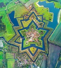
After experiencing its final battle in 1672, the fort continued to serve in the defensive network on the German border until it was finally given up in 1851 and converted into a village. Fort Bourtange currently serves as a historical museum.

History

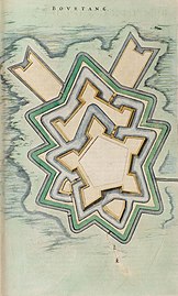
At the start of the Eighty Years' War (1568–1648), the Spaniards had control over Groningen and the passage to Germany through a marshy area. William, the instigator of the Dutch Revolt, deemed it necessary to seize control of the link between Groningen and Germany. He decided to have a fortification built in the Bourtange passage. A fort was completed in 1593, with a network of canals and lakes which were used as moats. Soon after its construction, Spanish forces from Groningen besieged it, though the attack ended in failure. [1]

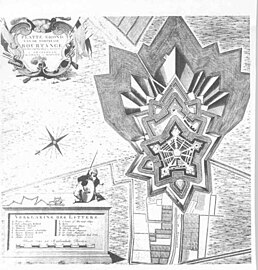
Fort Bourtange faced another siege in 1672 against invading forces of Christoph Bernhard von Galen the Prince-Bishop of Münster, France's German ally in the Franco-Dutch War. After capturing 18 cities and towns in the northern Netherlands, they demanded that the fort be surrendered. The fort's governor, Captain Protts, refused, and the Münsters replied with a frontal assault. Thanks to the surrounding marshes and the time-tested fortifications, the invading army was repelled successfully. [2]

After its conversion into a village in 1851, living conditions began to deteriorate. Over 100 years later in 1960, the local government decided to stop the decline by restoring the old fort to its 1740–50 appearance and converting into a historical museum.

Footnotes

Related Research Articles

<span class="mw-page-title-main">Groningen (province)</span> Northeasternmost province of the Netherlands

Groningen is the northeasternmost province of the Netherlands. It borders on Friesland to the west, Drenthe to the south, the German state of Lower Saxony to the east, and the Wadden Sea to the north. As of January 2023, Groningen had a population of about 596,000, and a total area of 2,955 km2 (1,141 sq mi).

<span class="mw-page-title-main">Bellingwedde</span> Municipality in Groningen, Netherlands

Bellingwedde was a municipality with a population of data missing in the province Groningen in the northeast of the Netherlands. Bellingwedde was established in 1968, when the municipalities of Bellingwolde and Wedde had merged. It contained the villages Bellingwolde, Blijham, Oudeschans, Veelerveen, Vriescheloo, and Wedde. After almost 50 year, Bellingwedde was disestablished in 2018, when the municipalities of Bellingwedde and Vlagtwedde had merged into Westerwolde.

<span class="mw-page-title-main">Ommen</span> Municipality in Overijssel, Netherlands

Ommen is a municipality and a Hanseatic city in the eastern Netherlands. It is located in the Vecht valley of the Salland region in Overijssel. Historical records first name Ommen in the early 12th century and it was officially founded as a city in 1248. The municipality had a population of 18,295 in 2021 and covers an area of 182.01 km2 (70.27 sq mi).

<span class="mw-page-title-main">Franco-Dutch War</span> 1672–1678 European war

The Franco-Dutch War, also known as the Dutch War, was fought between France and the Dutch Republic, supported by its allies the Holy Roman Empire, Spain, Brandenburg-Prussia and Denmark-Norway. In its early stages, France was allied with Münster and Cologne, as well as England. The 1672 to 1674 Third Anglo-Dutch War and 1675 to 1679 Scanian War are considered related conflicts.

<span class="mw-page-title-main">Bourtange</span> Village in Groningen, Netherlands

Bourtange is a village with a population of 430 in the municipality of Westerwolde in the Netherlands. It is situated in the region Westerwolde in the east of the province of Groningen near the German border. Fort Bourtange was built in 1593 during the Dutch Revolt and was used until 1851. Between 1967 and 1992 the star fort was gradually restored to its mid-18th-century state and it is currently an open-air museum.

<span class="mw-page-title-main">Lutjegast</span> Village in Groningen, Netherlands

Lutjegast is a village in the municipality of Westerkwartier in Groningen, Netherlands. It had a population of around 1,125 in January 2017.

<i>Rampjaar</i> 1672 in Dutch history

In Dutch history, the year 1672 is referred to as the Rampjaar. In May 1672, following the outbreak of the Franco-Dutch War and its peripheral conflict the Third Anglo-Dutch War, France, supported by Münster and Cologne, invaded and nearly overran the Dutch Republic. At the same time, it faced the threat of an English naval blockade in support of the French endeavor, though that attempt was abandoned following the Battle of Solebay. A Dutch saying coined that year describes the Dutch people as redeloos ("irrational"), its government as radeloos ("distraught"), and the country as reddeloos. The cities of the coastal provinces of Holland, Zealand and Frisia underwent a political transition: the city governments were taken over by Orangists, opposed to the republican regime of the Grand Pensionary Johan de Witt, ending the First Stadtholderless Period.

<span class="mw-page-title-main">Ommerschans</span> Hamlet in Overijssel, Netherlands

Ommerschans is a former bulwark in the Dutch province of Overijssel. It is a part of the municipality of Ommen, and lies about 16 km south of Hoogeveen.

<span class="mw-page-title-main">Siege of Groenlo (1595)</span>

The siege of Grol or Groenlo in 1595 was a siege of Groenlo by States forces under Maurice of Nassau during the Eighty Years' War in an attempt to capture it from the Spanish Empire. It lasted from 14 to 24 July 1595, ending with the arrival of a Spanish relief force under Cristóbal de Mondragón and Maurice's retreat. Two years later, in 1597, Maurice returned to carry out another siege of Groenlo. Both these sieges formed part of what would later be called the Ten Glorious Years.

<span class="mw-page-title-main">Siege of Groenlo (1672)</span>

The siege of Groenlo was a 10-day siege of the Dutch town of Groenlo from 1 to 10 June 1672 by the combined forces of France, the Elector of Cologne and the Prince-Bishop of Münster during the Franco-Dutch War. It ended in the town's surrender.

Fort Sint-Michiel was a Spanish fort situated in Venlo, the Netherlands. It was named after the archangel Michael. Construction of this fort started in 1641 on Michaelmas, September 29. It was demolished in 1867.

<span class="mw-page-title-main">Bourtange moor</span> Bog area in northern Germany and Netherlands

The Bourtanger Moor was a bog in eastern parts in the Dutch provinces of Drenthe and Groningen and the bordering German districts of Bentheim and Emsland. A remaining stretch on the border between Drenthe and the districts Emsland and Betheim is now a nature reserve, the Internationaler Naturpark Bourtanger Moor-Bargerveen.

<span class="mw-page-title-main">Oudeschans</span> Village in Groningen, Netherlands

Oudeschans is a small village with a population of around 100 in the municipality of Westerwolde in the province of Groningen in the Netherlands. The 16th-century fortification is now a state protected village area with several national heritage sites, among which a 17th-century garrison church, and the Vestingmuseum Oudeschans.

<span class="mw-page-title-main">Vestingmuseum Oudeschans</span> Local museum, History museum in Oudeschans, Netherlands

Vestingmuseum Oudeschans is a local museum in the village of Oudeschans in the Netherlands. The museum shows the history of the 16th-century fortification of Oudeschans and has a collection of archaeological findings.

<span class="mw-page-title-main">Siege of Rees (1599)</span>

The siege of Rees of 1599, also known as the relief of Rees, was an unsuccessful attempt by Protestant-German forces led by Count Simon VI of Lippe, and Anglo-Dutch forces sent by Prince Maurice of Nassau, commanded by Philip of Hohenlohe-Neuenstein and the Count Ernst of Solms, to capture the strategic stronghold of Rees, Lower Rhine, Duchy of Cleves from the Spanish forces of Don Francisco de Mendoza, Admiral of Aragon, second-in-command of the Army of Flanders, and Governor Don Ramiro de Guzmán, between 10–12 September 1599, during the Eighty Years' War and the Anglo-Spanish War (1585–1604). This Spanish victory was part of the campaign of Francisco de Mendoza and Cardinal Andrew of Austria of 1598-1599, also called the Spanish Winter of 1598-99.

<span class="mw-page-title-main">France–Netherlands relations</span> Bilateral relations

France–Netherlands relations are the interstate and bilateral relations between France and the Netherlands. The two countries notably share a border division in the Caribbean island of Saint Martin, to which the northern part of the island is a French overseas collectivity known as the Collectivity of Saint Martin, while the southern part of the island is a Dutch constituent country known as Sint Maarten. Relations between the two countries date back to the 17th and 18th centuries when a conflict led to the transformation of the Dutch Republic to the Batavian Republic and eventually the Kingdom of Holland. The two countries currently enjoy close cultural and economic relations. Both nations are members of the OECD and Organization for Security and Co-operation in Europe, as well as founding members of the European Union, NATO, and the United Nations.

<span class="mw-page-title-main">Siege of Geertruidenberg (1593)</span> Siege that took place during Eighty Years War and the Anglo-Spanish War

The siege of Geertruidenberg was a siege of the city of Geertruidenberg that took place between 27 March and 24 June 1593 during the Eighty Years' War and the Anglo–Spanish War. Anglo-Dutch troops under the commands of Maurice of Nassau and Francis Vere laid siege to the Spanish garrisoned city. The siege was unique in that the besiegers used a hundred ships, forming a semicircle in a chain on the Mass river to form a blockade. A Spanish force under the command of the Count of Mansfeld attempted to relieve the city in May, but they were defeated and later forced to withdraw. Three Governors of the city were killed - after the last fatality and as a result of the failed relief, the Spanish surrendered the city on 24 June 1593. The victory earned Maurice much fame and had thus become a steadfast strategist in the art of war.

<span class="mw-page-title-main">Siege of Coevorden (1593)</span> Part of the Eighty Years War and the Anglo–Spanish War

The siege of Coevorden was a thirty-one-week siege of the city of Coevorden in the province of Drenthe by the Spanish general Francisco Verdugo during the Eighty Years' War and the Anglo–Spanish War. The siege first commenced in October 1593, but winter and shortages of food and supplies forced the Spanish into winter quarters. The siege however recommenced in March 1594, but on May 6 Maurice of Orange arrived with an Anglo-Dutch army to relieve Coevorden, forcing the Spanish army under Francisco Verdugo to retreat.

The Luxemburg campaigns were two military campaigns by the Dutch Republic and the Duchy of Bouillon against the Spanish Southern Netherlands during the Eighty Years' War in 1593 and 1595. The first was undertaken by a Dutch States Army commanded by Philip of Nassau to the Duchy of Luxemburg in early 1593, with the aim of distracting the Spanish Army of Flanders to a different part of the Habsburg Netherlands, create confusion and block the importation of new pro-Spanish troops to the Low Countries via the Spanish Road. Other goals were dealing economic damage to Spain, and supporting the Protestant claimant to the French throne Henry of Navarre and the Protestant prince of Sedan and duke of Bouillon, Henry de La Tour d'Auvergne.

<span class="mw-page-title-main">Winschoterzijl</span> Former hamlet in Groningen, Netherlands

Winschoterzijl is a former hamlet in the municipality of Oldambt in the northeast of the Netherlands. It was also a sconce, and is still a lock. The village was settled by Lutheran refugees from East Frisia during the Thirty Years' War (1618–1648). In 1992, Winschoterzijl was demolished during the widening of the Pekel A.

References