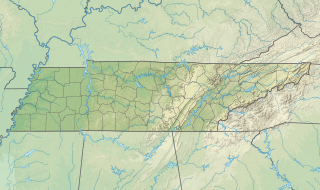
The Mississippi River is the second-longest river and chief river of the second-largest drainage system on the North American continent, second only to the Hudson Bay drainage system. From its traditional source of Lake Itasca in northern Minnesota, it flows generally south for 2,340 miles (3,770 km) to the Mississippi River Delta in the Gulf of Mexico. With its many tributaries, the Mississippi's watershed drains all or parts of 32 U.S. states and two Canadian provinces between the Rocky and Appalachian mountains. The main stem is entirely within the United States; the total drainage basin is 1,151,000 sq mi (2,980,000 km2), of which only about one percent is in Canada. The Mississippi ranks as the fourteenth-largest river by discharge in the world. The river either borders or passes through the states of Minnesota, Wisconsin, Iowa, Illinois, Missouri, Kentucky, Tennessee, Arkansas, Mississippi, and Louisiana.

The Ohio River is a 981-mile (1,579 km) long river in the United States. It is located at the boundary of the Midwestern and Southern United States, flowing southwesterly from far-western Pennsylvania south of Lake Erie to its mouth on the Mississippi River at the southern tip of Illinois. It is the third largest river by discharge volume in the United States and the largest tributary by volume of the north-south flowing Mississippi River that divides the eastern from western United States. The river flows through or along the border of six states, and its drainage basin includes parts of 14 states. Through its largest tributary, the Tennessee River, the basin includes several states of the southeastern U.S. It is the source of drinking water for three million people.
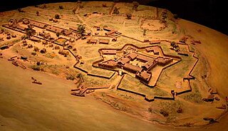
Fort Duquesne was a fort established by the French in 1754, at the confluence of the Allegheny and Monongahela rivers. It was later taken over by the British, and later Americans, and developed as Pittsburgh in the U.S. state of Pennsylvania. Fort Duquesne was destroyed by the French, prior to British conquest during the Seven Years' War, known as the French and Indian War on the North American front. The latter replaced it, building Fort Pitt between 1759 and 1761. The site of both forts is now occupied by Point State Park, where the outlines of the two forts have been laid in brick.

Alexander County is the southernmost and southwesternmost county in the U.S. state of Illinois. As of the 2010 census, the population was 8,238. Its county seat is Cairo and its western boundary is formed by the Mississippi River.
Cairo is the southernmost city in Illinois and the county seat of Alexander County.

Mound City is a city located along the Ohio River just north of its confluence with the Mississippi River in Pulaski County, Illinois, United States. As of the 2010 census, the city population was 588. It is the county seat of Pulaski County.

Defiance is a city in and the county seat of Defiance County, Ohio, about 55 miles (89 km) southwest of Toledo and 47 miles (76 km) northeast of Fort Wayne, Indiana, in Ohio's northwestern corner. The population was 16,494 at the 2010 census.
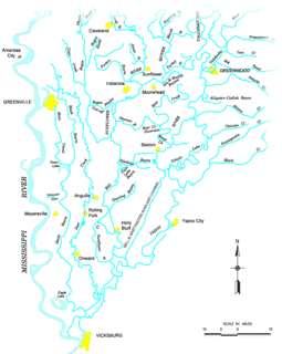
The Yazoo River is a river in the U.S. states of Louisiana and Mississippi. It is considered by some to mark the southern boundary of what is called the Mississippi Delta, a broad floodplain that was cultivated for cotton plantations before the American Civil War. It has continued to be devoted to large-scale agriculture.

The Battle of Fort Henry was fought on February 6, 1862, in Donelson, Stewart County, Tennessee, during the American Civil War. It was the first important victory for the Union and Brig. Gen. Ulysses S. Grant in the Western Theater.

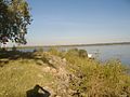
Southern Illinois, also known as Little Egypt, is the southern third of Illinois, principally along and south of Interstate 64. The area has a unique cultural and regional history. Although part of a Midwestern state, this region is aligned in culture more with that of the Upland South than the Midwest. Part of downstate Illinois, it is bordered by the two most voluminous rivers in the United States: the Mississippi below its connecting Missouri River to the west and the Ohio River to the east and south with the Wabash as tributary.

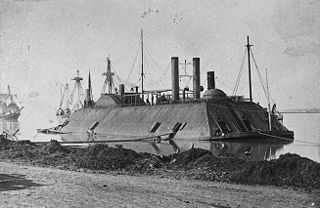
USS Cairo was one of the first American ironclad warships built at the beginning of the U.S. Civil War.
Bird's Point is an unincorporated community in Mississippi County, Missouri, United States. It lies on an island or former island in the Mississippi River, near the confluence of the Ohio and Mississippi Rivers and is situated directly across from Cairo, Illinois. This is the point where the U.S. Route 60 bridge connects with Cairo.

In geography, a confluence occurs where two or more flowing bodies of water join together to form a single channel. A confluence can occur in several configurations: at the point where a tributary joins a larger river ; or where two streams meet to become the source of a river of a new name ; or where two separated channels of a river rejoin at the downstream end.

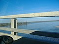
The Cairo Mississippi River Bridge is a type of cantilever bridge known as a Steel Truss Through Deck carrying U.S. Route 60 and U.S. Route 62 across the Mississippi River. Located in the tri-state area of Illinois, Kentucky, and Missouri, it connects Cairo, Illinois at its northern terminus to Bird's Point, Missouri at its southern terminus. The bridge was most recently closed for renovation from March 16, 2015 to October 13, 2015.
Island Number Ten was an island in the Mississippi River near Tiptonville, Tennessee and the site of a major eponymous battle in the American Civil War.
USS Alfred Robb (1860) was a stern wheel steamer captured by the Union Navy during the American Civil War.
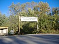
Fort Defiance was a fort built during the American Civil War at Clarksville, Tennessee, on the Cumberland River. It changed hands several times during the war, and is now preserved by the city administration.
The Battle of Lucas Bend took place on January 11, 1862 near Lucas Bend, four miles north of Columbus on Mississippi River in Kentucky as it lay at the time of the American Civil War. In the network of the Mississippi, Tennessee and Ohio rivers, the Union river gunboats under Flag Officer Andrew Hull Foote and General Ulysses S. Grant sought to infiltrate and attack the Confederate positions in Tennessee. On the day of the battle, the Union ironclads Essex and St Louis, transporting troops down the Mississippi in fog, engaged the Confederate cotton clad warships General Polk, Ivy and Jackson and the gun platform New Orleans at a curve known as Lucas Bend in Kentucky. The Essex, under Commander William D. Porter, and the St Louis forced the Confederate ships to fall back after an hour of skirmishing during which the Union commander was wounded. They retreated to the safety of a nearby Confederate battery at Columbus, where the Union vessels could not follow.
U.S. Route 60 and U.S. Route 62 (US 60/US 62) run for a very short distance within the state of Illinois. The highways run concurrently for their entire existence within the state. The joint highway runs around Fort Defiance in Cairo, from the Cairo Mississippi River Bridge over the Mississippi River east to the Cairo Ohio River Bridge over the Ohio River; the Ohio River Bridge also carries US 51. The bridges cross the two rivers just north of the mouth of the Ohio.
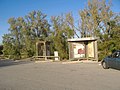
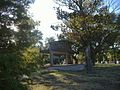
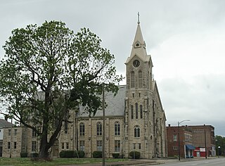
The Alexander County Courthouse is a government building in central Cairo, the county seat of Alexander County, Illinois, United States. Built in the 1960s, it is the latest in a series of courthouses erected in four towns across Alexander County.