Fort Fizzle (Montana)

Last updated

Fort Fizzle was a temporary military barricade in the western United States, erected by the U.S. Army in July 1877. Its purpose was to intercept the Nez Perce in their flight from north central Idaho over Lolo Pass into the Bitterroot Valley of western Montana. The name describes the effectiveness of the fort.

Contents

Fort Fizzle Site
USA Montana location map.svg
Red pog.svg
Usa edcp location map.svg
Red pog.svg
Nearest city Lolo, Montana
Coordinates 46°44′47″N114°10′19″W / 46.7463°N 114.172°W / 46.7463; -114.172 Coordinates: 46°44′47″N114°10′19″W / 46.7463°N 114.172°W / 46.7463; -114.172
Area120.4 acres (48.7 ha)
Built by U.S. Army
NRHP reference No. 77000821 [1]
Added to NRHPJuly 21, 1977

Background

In the Nez Perce War of 1877, the U.S. Army defeated, but did not demoralize, the Nez Perce under Chief Joseph at the Battle of the Clearwater, July 11–12. Pursued by General O. O. Howard the Nez Perce, numbering about 200 warriors and 750 persons in total along with more than 2,000 horses, decided to flee across Lolo Pass into the Bitterroot Valley and onward to the Great Plains.

The Nez Perce were familiar with this region, having been frequent visitors while en route to the plains to hunt buffalo. Their leader Looking Glass persuaded the other Nez Perce leaders that they would be safe from the U.S. Army in Montana and that he could lead them to a safe refuge among his friends, the Crow Indians. [2]

The Nez Perce route across Lolo Pass to Fort Fizzle and beyond Nez Perce route.png
The Nez Perce route across Lolo Pass to Fort Fizzle and beyond

The Army and the Nez Perce

A reconstruction of part of Fort Fizzle at Fort Fizzle Historic Site in Montana. Fort Fizzle.jpg
A reconstruction of part of Fort Fizzle at Fort Fizzle Historic Site in Montana.

White settlers and U.S. Army soldiers in the Bitterroot Valley, informed by telegraph that the Nez Perce were coming their way, prepared to defend themselves. Captain Charles Rawn had only 35 soldiers to defend the valley. On July 23, two white youths who had been prisoners of the Nez Perce reported to Rawn that the Nez Perce were camped at Lolo Hot Springs, on the Montana side of the pass and only a few miles from the white settlements in the Bitterroot Valley. The youths had been released to bring a message from the Nez Perce that they wished to pass peacefully through the settlements. Rawn, however, was ordered to "compel the Indians to surrender their arms and ammunition, and to dispute their passage, by force of arms, into Bitterroot Valley." [3]

On July 25, Rawn, his 35 soldiers and 50 civilian volunteers constructed a wooden barricade of logs and earth two or three miles (5 km) below where the Nez Perce were camped and about five miles (8 km) west of Lolo, Montana. On July 26, Rawn met with Looking Glass who requested to traverse the Bitterroot Valley without violence. Rawn demanded that the Nez Perce surrender their arms and ammunition and the meeting terminated without any decision.

The next day, 216 armed men, including 15 to 20 Flathead Indian scouts were gathered at the improvised fort and the Governor of Montana, Benjamin F. Potts, had arrived. Rawn and Looking Glass met again and each repeated their demands. When Rawn returned to the fort and said that he anticipated a battle with the Nez Perce, most of the volunteers left, declaring that "no act of hostility on their part should provoke the Indians." The next morning, July 27, less than 100 men were left to man the fort and oppose the Nez Perce. [4] Governor Potts had also found reason to depart. [5]

According to Chief Joseph, Captain Rawn agreed to allow the Nez Perce to pass through Bitterroot Valley in peace. Rawn never admitted making such an agreement.

The barricade where Rawn and his men were entrenched was in a constricted 200-yard (180 m) wide passage in the Lolo Creek canyon, enclosed on both sides by precipitous ridges where "a goat could not pass." Nevertheless, on July 28 the Nez Perce – men, women, children, and livestock—climbed the ridges to the north and bypassed the barricade, leaving the defenders in their rear. Rawn and his soldiers exchanged a few shots with the Nez Perce on the ridge and then abandoned the fort and followed them down into the Bitterroot Valley at a safe distance. An advance party of soldiers bumped into the rear guard of the Nez Perce. Looking Glass exchanged friendly greetings with them. [6] Fifty of the civilian volunteers stumbled into the Nez Perce camp and were captured, but were released after Looking Glass promised no violence against anybody. [7] The soldiers retired to Missoula, the civilian volunteers disbanded, and the Nez Perce continued on their way south through the Bitterroot Valley, buying fresh horses, food, and supplies from local ranchers and farmers. [8] [9]

Thus, the makeshift fort acquired its name -- "Fort Fizzle." [10]

The aftermath

The Fort Fizzle fiasco prompted volleys of charges and counter-charges of cowardice and ineptitude between and among the government and citizens of Montana and the U.S. government and its army. A volunteer explained that "we were not silly enough to uselessly incite the Indians to devastate our valley." Many Montanans, including the governor and fire-breathing journalists, began to comment favorably on the "bravery" and "audacity" of the Nez Perce and the wisdom of the citizens in avoiding an armed encounter. [11] [12]

However, the respite from war of the Nez Perce was brief. Lulled into complacency by their peaceful passage through the Bitterroot Valley, they would be attacked on August 9 by Colonel John Gibbon and 200 men in the bloody Battle of the Big Hole.

A portion of the fort has been reconstructed at Fort Fizzle Historic Site, [13] adjacent to U.S. Route 12. The site parallels the historic Lolo trail once used by the Nez Perce, Salish, and Kootenai tribes and Lewis and Clark. Lewis and Clark's westbound expedition ascended Lolo Creek in mid-September 1805, and they revisited the area on their way back east in late June 1806. [14]

Related Research Articles

Nez Perce Indigenous peoples of North America

The Nez Percé are an Indigenous people of the Plateau who are presumed to have lived on the Columbia River Plateau in the Pacific Northwest a region for at least 11,500 years.

Chief Joseph 19th-century Native American leader

Hin-mah-too-yah-lat-kekt, popularly known as Chief Joseph, Young Joseph, or Joseph the Younger, was a leader of the Wal-lam-wat-kain (Wallowa) band of Nez Perce, a Native American tribe of the interior Pacific Northwest region of the United States, in the latter half of the 19th century. He succeeded his father Tuekakas in the early 1870s.

Nez Perce War 1877 armed conflict between the U.S. Army and Native Americans in the Pacific Northwest

The Nez Perce War was an armed conflict that pitted several bands of the Nez Perce tribe of Native Americans and their allies, a small band of the Palouse tribe led by Red Echo (Hahtalekin) and Bald Head, against the United States Army. The conflict, fought between June and October 1877, stemmed from the refusal of several bands of the Nez Perce, dubbed "non-treaty Indians," to give up their ancestral lands in the Pacific Northwest and move to an Indian reservation in Idaho. This forced removal was in violation of the 1855 Treaty of Walla Walla, which granted the tribe 7.5 million acres of their ancestral lands and the right to hunt and fish on lands ceded to the U.S. government.

Lolo Pass (Idaho–Montana) United States historic place

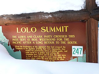
Lolo Pass, elevation 5,233 feet (1,595 m), is a mountain pass in the western United States, in the Bitterroot Range of the northern Rocky Mountains. It is on the border between the states of Montana and Idaho, approximately 40 miles (65 km) west-southwest of Missoula, Montana.

Clearwater National Forest National forest in Idaho, United States

Clearwater National Forest with headquarters on the Nez Perce Reservation at Kamiah is located in North Central Idaho in the northwestern United States. The forest is bounded on the east by the state of Montana, on the north by the Idaho Panhandle National Forest, and on the south and west by the Nez Perce National Forest and Palouse Prairie.

Battle of the Big Hole 1877 battle of the Nez Perce War

The Battle of the Big Hole was fought in Montana, August 9–10, 1877, between the U.S. Army and the Nez Perce tribe of Native Americans during the Nez Perce War. Both sides suffered heavy casualties. The Nez Perce withdrew in good order from the battlefield and continued their long fighting retreat that would result in their attempt to reach Canada and asylum.

Battle of the Clearwater

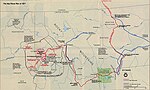
The Battle of the Clearwater was a battle between the Nez Perce under Chief Joseph and the United States army. The army under General O. O. Howard surprised a Nez Perce village. The Nez Perce counter-attacked and inflicted significant casualties on the soldiers, but they were forced to abandon the village. After the battle, the Nez Perce retreated and crossed the Bitterroot Mountains via Lolo Pass with General Howard in pursuit.

Battle of Bear Paw United States historic place

The Battle of Bear Paw was the final engagement of the Nez Perce War of 1877. Following a 1,200-mile (1,900 km) running fight from western Idaho over the previous four months, the U.S. Army managed to corner most of the Nez Perce led by Chief Joseph in early October 1877 in northern Montana Territory, just 42 miles (68 km) south of the border with Canada, where the Nez Perce intended to seek refuge from persecution by the U.S. government.

Bitterroot Valley

The Bitterroot Valley is located in southwestern Montana, along the Bitterroot River between the Bitterroot Range and Sapphire Mountains, in the Northwestern United States.

Battle of Camas Creek

The Battle of Camas Creek, August 20, 1877, was a raid by the Nez Perce Indians on a U.S. Army encampment and a subsequent battle during the Nez Perce War. The Nez Perce defeated three companies of U.S. cavalry and continued their fighting retreat to escape the U.S. Army.

Bitterroot National Forest U.S. Forest across Montana and Idaho

Bitterroot National Forest comprises 1.587 million acres (6,423 km²) in west-central Montana and eastern Idaho, of the United States. It is located primarily in Ravalli County, Montana, but also has acreage in Idaho County, Idaho (29.24%), and Missoula County, Montana (0.49%).

The Battle of White Bird Canyon was fought on June 17, 1877 in Idaho Territory. White Bird Canyon was the opening battle of the Nez Perce War between the Nez Perce Indians and the United States. The battle was a significant defeat of the U.S. Army. It took place in the western part of present-day Idaho County, southwest of the city of Grangeville.

Looking Glass (Native American leader)

Looking Glass was a principal Nez Perce architect of many of the military strategies employed by the Nez Perce during the Nez Perce War of 1877. He, along with Chief Joseph, directed the 1877 retreat from eastern Oregon into Montana and onward toward the Canada–US border during the Nez Perce War. He led the Alpowai band of the Nez Perce, which included the communities of Asotin, Alpowa, and Sapachesap along the Clearwater River in Idaho. He inherited his name from his father, the prominent Nez Percé chief Apash Wyakaikt or Ippakness Wayhayken and was therefore called by the whites Looking Glass.

Battle of Canyon Creek

The Battle of Canyon Creek was a military engagement between the Nez Perce Indians and the United States 7th Cavalry. The battle was part of the larger Indian Wars of the latter 19th century and the immediate Nez Perce War. It took place on September 13, 1877, west of present-day Billings, Montana in the canyons and benches around Canyon Creek.

Fort Missoula United States historic place

Fort Missoula was established by the United States Army in 1877 on land that is now part of the city of Missoula, Montana, to protect settlers in Western Montana from possible threats from the Native American Indians, such as the Nez Perce.

U.S. Route 12 is a federal highway in north central Idaho. It extends 174.210 miles (280.364 km) from the Washington state line in Lewiston east to the Montana state line at Lolo Pass, generally along the route of the Lewis and Clark expedition, and is known as the Northwest Passage Scenic Byway It was previously known as the Lewis and Clark Highway.

Ollokot

Ollokot,, was a war leader of the Wallowa band of Nez Perce Indians and a leader of the young warriors in the Nez Perce War in 1877.

Toohoolhoolzote was a Nez Perce leader who fought in the Nez Perce War, after first advocating peace, and died at the Battle of Bear Paw.

Battle of Cottonwood

The Battle of Cottonwood was a series of engagements July 3–5, 1877 in the Nez Perce War between the Native American Nez Perce people, and U.S. Army soldiers and civilian volunteers. Near Cottonwood, Idaho the Nez Perce, led by Chief Joseph, brushed aside the soldiers and continued their 1,170 miles (1,880 km) fighting retreat to cross the Rocky Mountains in an attempt to reach safety in Canada.

Nez Perce in Yellowstone Park

The Nez Perce in Yellowstone Park was the flight of the Nez Perce Indians through Yellowstone National Park between August 20 and Sept 7, during the Nez Perce War in 1877. As the U.S. army pursued the Nez Perce through the park, a number of hostile and sometimes deadly encounters between park visitors and the Indians occurred. Eventually, the army's pursuit forced the Nez Perce off the Yellowstone plateau and into forces arrayed to capture or destroy them when they emerged from the mountains of Yellowstone onto the valley of Clark's Fork of the Yellowstone River.

References

  1. "National Register Information System". National Register of Historic Places . National Park Service. July 9, 2010.
  2. Beal, Merrill D. (1963). "I Will Fight no More Forever." Chief Joseph and the Nez Perce War. Seattle, WA: University of Washington Press. pp. 79–80.
  3. Greene, Jerome A. (2000). "5". Nez Perce Summer 1877: The U.S. Army and the Nee-Me-Poo Crisis. Helena, MT: Montana Historical Society Press. ISBN   0917298683.
  4. Hampton, Bruce (1994). Children of Grace: The Nez Perce War of 1877 . New York: Henry Holt and Company. pp.  140–141.
  5. Josephy, Jr., Alvin M. (1965). The Nez Perce Indians and the Opening of the Northwest. New Haven, CT: Yale University Press. p. 571.
  6. Brown, Mark H. (1967). The Flight of the Nez Perce. New York: G. P. Putnam’s Sons. p. 225.
  7. Josephy, p. 573
  8. Brown, p. 233
  9. Hampton, p. 142
  10. Josephy, p. 572
  11. Brown, p. 226
  12. Hampton, pp. 144-145
  13. "Fort Fizzle Historic Site Picnic Ground". U.S. Forest Service. Retrieved April 16, 2012.
  14. "Fort Fizzle". Montana. Retrieved 2016-02-05.