From the latter part of the 17th century, the outlet of Rainy Lake was an important site for the North American fur trade, because it provided a vital link from Lake Superior to the west. In 1688, the first French post was established there.[2]
In 1818, following the War of 1812 and the redefinition of borders between Canada and the United States, the Hudson's Bay Company (HBC) built a fort here, originally called Lac la Pluie House. In 1822, the post became the headquarters for the Lac la Pluie District, created that same year, and attracted a growing population of European settlers.[2] In 1830, HBC Chief Factor John Dugald Cameron[4] renamed the fur trading post after Frances Ramsay Simpson, the 18-year-old daughter of a London merchant,[5] who had married earlier that year in London, George Simpson, Governor of the Hudson's Bay Company, who would visit the fort many times. In 1841 she became Lady Simpson after George Simpson was knighted, and she died in 1853 at Lachine, Quebec.[6]
In 1857 to 1858, the Dawson Trail was surveyed, connecting Fort Frances to Fort William to the east and the Red River Colony to the west, and making the town a supply depot for travelers. In the mid-1880s, the railroad to Kenora was completed.[2]
July 1st parade, Fort Frances, ca. 1905
Fort Frances was incorporated in 1903. That same year, the HBC store burned down and was not rebuilt.[2]
On June 25, 1946, the town was struck by a tornado, which caused major damage and struck a week after the deadly Windsor tornado.
On August 25, 2013, the town hosted the final pitstop in the Kraft Celebration Tour by receiving the most votes out of all 20 communities
On January 14, 2014, Resolute Forest Products announced that it planned to stop operations of the final paper machine and close out its operations in Fort Frances by the end of the month.
On December 13, 2014, Tim Hortons filmed a commercial in Fort Frances. The commercial, which dubs Fort Frances "one of the coldest places in Canada", was shot at the local Tim Hortons. In the days leading up to the filming, yarn was seen covering trees, benches, etc. Workers had spent the night covering the interior of the restaurant with yarn and building a giant toque on the roof. For the day, the coffee was free.
In August 2015 the Seven Generations Education Institute hosted the World Indigenous Nations Higher Education Consortium's (WINHEC) Annual General Meeting at the Nanicost Grounds for members attending from all over the world.
Fort Frances, along with Atikokan hold the record for the highest temperature ever recorded in the province of Ontario. On 13 July 1936 the mercury climbed to 42.2°C (108.0°F).
In the 2021 Census of Population conducted by Statistics Canada, Fort Frances had a population of 7,466 living in 3,451 of its 3,779 total private dwellings, a change of -3.5% from its 2016 population of 7,739. With a land area of 25.55km2 (9.86sqmi), it had a population density of 292.2/km2 (756.8/sqmi) in 2021.[1]
Fort Frances had a population of 7,739 people in 2016, which represents a decrease of 2.7% from the 2011 census count. The median household income in 2015 for Fort Frances was $62,928, which was below the Ontario provincial average of $74,287.[10]
In 2021, Statistics Canada reported that the age demographic broke down as follows for Fort Frances:
The Fort Frances Paper Mill was formerly the main employer and industry in the town until its closure in January 2014.[27] Today, there is no manufacturing or major industry in Fort Frances. Healthcare, social services and the town corporation make up the majority of the top tier employers, with big box retail coming in second. New Gold, a Canadian mining company, acquired mineral rights to the area in 2013. The Rainy River mine commenced processing ore on September 14, 2017 and completed its first gold pour on October 5, 2017.[28]
Couchiching First Nations Arena also known as "The Duke" – located in neighboring Couchiching First Nation
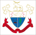
Coat of arms
The city coat of arms features a bull moose; maple leaves; a "Magneto", representative of electricity (industry); two men in a canoe; a white pine tree; and the motto "Industry and Perseverance."
Transportation
There are three airports in the area, one of which is in the United States. The two city airports are for general aviation and the other is a privately owned floatplane base.
Fort Frances Municipal Airport does not have regularly scheduled commercial airline service. It was previously served by only one company, Bearskin Airlines, with flights to and from Kenora, Winnipeg, Thunder Bay, and Dryden. Falls International Airport has flights to Minneapolis–Saint Paul by Delta Connection.
Train, truck and car traffic to and from the United States traverses the International Bridge.
Fort Frances Transit operated until 1996, and Fort Frances Handi-Van Transit is a provincially-funded service run by the Town of Fort Frances. Caribou Coach Transportation Company Incorporated cancelled its bus route to and from Thunder Bay in October 2017. The route was once served by Greyhound Canada. North Air operates a taxi service from Fort Frances whose service area includes the International Falls, Minnesota area and airport.
Another radio station, CKWO FM 92.3 The Wolf, was licensed to the neighbouring Couchiching First Nation in 2003 [31] and launched in 2004. Its unknown when the station left the air; the CRTC renewed CKWO-FM's licence from 1 September 2012 to 28 February 2013, with no known license renewals since that date.[32]
↑Temperature and precipitation normals were collected at Fort Frances Airport for the period 1981−2010. Extreme high and low temperatures were recorded in the town of Fort Frances from January 1892 to September 1995 and at Fort Frances Airport from August 1976 to present.
This page is based on this Wikipedia article Text is available under the CC BY-SA 4.0 license; additional terms may apply. Images, videos and audio are available under their respective licenses.