
Chaves is a city and a municipality in the north of Portugal. It is 10 km south of the Spanish border and 22 km south of Verín (Spain). The population in 2011 was 41,243, in an area of 591.23 km2. The municipality is the second most populous of the district of Vila Real. With origins in the Roman civitas Aquæ Flaviæ, Chaves has developed into a regional center. The urban area has 17,535 residents (2001).

Praia da Vitória is a municipality in the Portuguese archipelago of the Azores. With a population of 21,035, the second largest administrative authority on the island of Terceira, it covers an area of 161.27 square kilometres (62.27 sq mi), that extends from the northern coast halfway into the interior.
Vila do Porto is the single municipality, the name of the main town and one of the civil parishes on the island of Santa Maria, in the Portuguese archipelago of Azores. Its nearest neighbor, administratively, is the municipality of Povoação on the southern coast of São Miguel, and it is physically southwest of the islets of the Formigas. The population in 2021 was 5,408, in an area of 96.89 km2 (37.41 sq mi).

Pilar da Bretanha is a civil parish in the municipality of Ponta Delgada on the island of São Miguel, in the Portuguese archipelago of the Azores. It was de-annexed from the historical parish of Bretanha on 10 July 2002, along with Ajuda da Bretanha. The population in 2011 was 624, in an area of 6.07 square kilometres (2.34 sq mi). It contains the localities Casa Telhada, Covas, João Bom and Pilar.

São José is a civil parish in the municipality of Ponta Delgada on the island of São Miguel in the Portuguese archipelago of the Azores. It is one of the constituent parts of the city of Ponta Delgada, and location of many of the island's more significant cultural and historical, commercial and residential buildings. Extending a short distance along the coast it, nevertheless includes a large mixed urban-rural constituency from the shore north to the main freeway, the Via-Rápida. The population in 2011 was 5,934, in an area of 1.66 km2.

Ribeira Grande is a municipality in the northern part of the island of São Miguel in the Portuguese Azores. The population in 2011 was 32,112, in an area of 180.15 km2. The municipal seat is located in the civil parish of Matriz, with a population of about 4000 inhabitants, part of the urbanized core of what is commonly referred to as the city of Ribeira Grande.

Porto Formoso is a civil parish in the municipality of Ribeira Grande in the Portuguese archipelago of the Azores. The population in 2011 was 1,265, in an area of 12.79 km².

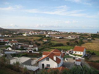
Ribeira Seca is a civil parish in the municipality of Ribeira Grande in the Portuguese archipelago of the Azores. The population in 2011 was 2,950, in an area of 12.59 km2. It is located near the north coast of the island. It contains the localities Bandejo, Morro de Cima and Ribeira Seca.

Vila Franca do Campo is a town and municipality in the southern part of the island of São Miguel in the Portuguese Autonomous Region of the Azores. The population of the municipality was 11,229 in 2011, in an area of 77.97 km². The town proper, which incorporates the urbanized parishes São Miguel and São Pedro, has 4100 inhabitants.

Almagreira is a civil parish in the municipality of Vila do Porto on the island of Santa Maria, in the Portuguese autonomous region of Azores. The population in 2011 was 599, in an area of 11.22 km². Bordering all other parishes of the island, it is located northwest of Vila do Porto.

Penafiel ([pɨnɐfiˈɛl]or is a municipality and former bishopric in the northern Portuguese district of Porto. Capital of the Tâmega Subregion, the population was 72,265 in 2011, in an area of 212.24 square kilometres.

Mangualde is a municipality in the subregion of Dão-Lafões, central region of Portugal. The population in 2011 was 19,880, in an area of 219.26 km2.

Lagoa is a city and municipality in the district of Faro, in the Portuguese region of Algarve. The population of the municipality in 2011 was 22,975, in an area of 88.25 km². Its urban population, in the city of Lagoa proper, is 6,100 inhabitants. An important travel destination, its coast has won numerous accolades. Marinha Beach was considered by the Michelin Guide as one of the 10 most beautiful beaches in Europe and as one of the 100 most beautiful beaches in the world.

Torrão is a civil parish and town, in the municipality of Alcácer do Sal, in the Portuguese district of Setúbal, bordering on the districts of Évora and the Beja. It is crossed by the river Xarrama River. The population in 2011 was 2,295, in an area of 372.39 km2.

Fort São João Baptista, also known as Fort of Nossa Senhora da Assunção, is located at the mouth of the river Ave, in the town of Vila do Conde, district of Porto, in Portugal.

The Fort Santa Maria da Arrábida also referred to as Fort Nossa Senhora da Arrábida, Fort of Arrábida and Fort of Portinho da Arrábida, is located at the foot of the southern slope of the mountain range of the same name, in a dominant position to southwest of Portinho da Arrábida, on the northern bank of the Sado River, in the Municipality and District of Setúbal, in Portugal.
