
The Seminole Wars were a series of three military conflicts between the United States and the Seminoles that took place in Florida between about 1816 and 1858. The Seminoles are a Native American nation which coalesced in northern Florida during the early 1700s, when the territory was still a Spanish colonial possession. Tensions grew between the Seminoles and settlers in the newly independent United States in the early 1800s, mainly because enslaved people regularly fled from Georgia into Spanish Florida, prompting slaveowners to conduct slave raids across the border. A series of cross-border skirmishes escalated into the First Seminole War in 1817, when American General Andrew Jackson led an incursion into the territory over Spanish objections. Jackson's forces destroyed several Seminole and Black Seminole towns, as well as the briefly occupied Pensacola before withdrawing in 1818. The U.S. and Spain soon negotiated the transfer of the territory with the Adams-Onis Treaty of 1819.

Osceola, named Billy Powell at birth in Alabama, became an influential leader of the Seminole people in Florida. His mother was Muscogee, and his great-grandfather was a Scotsman, James McQueen. He was reared by his mother in the Creek (Muscogee) tradition. When he was a child, they migrated to Florida with other Red Stick refugees, led by a relative, Peter McQueen, after their group's defeat in 1814 in the Creek Wars. There they became part of what was known as the Seminole people.

The Second Seminole War, also known as the Florida War, was a conflict from 1835 to 1842 in Florida between the United States and groups of people collectively known as Seminoles, consisting of American Indians and Black Indians. It was part of a series of conflicts called the Seminole Wars. The Second Seminole War, often referred to as the Seminole War, is regarded as "the longest and most costly of the Indian conflicts of the United States". After the Treaty of Payne's Landing in 1832 that called for the Seminole's removal from Florida, tensions rose until fierce hostilities occurred in the Dade battle in 1835. This conflict started the war. The Seminoles and the U.S. forces engaged in mostly small engagements for more than six years. By 1842, only a few hundred native peoples remained in Florida. Although no peace treaty was ever signed, the war was declared over on August 14, 1842.

The Castillo de San Marcos is the oldest masonry fort in the continental United States; it is located on the western shore of Matanzas Bay in St. Augustine, Florida.
The Battle of Lake Okeechobee was one of the major battles of the Second Seminole War. It was fought between 800 troops of the 1st, 4th, and 6th Infantry Regiments and 132 Missouri Volunteers, and between 380 and 480 Seminoles led by Billy Bowlegs, Abiaca, and Halpatter Tustenuggee (Alligator) on 25 December 1837. Halpatter Tustenuggee had played a major role in the Dade Battle two years earlier. The Seminole warriors were resisting forced relocation to a reservation in Oklahoma. Though both the Seminoles and Taylor's troops emerged from the battle claiming victory, Taylor was promoted to the rank of brigadier general as a result, and his nickname of "Old Rough and Ready" came mostly due to this battle.
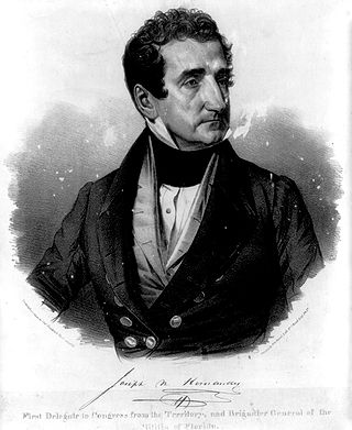
Joseph Marion Hernández was a slave-owning American planter, politician and military officer. He was the first delegate from the Florida Territory and the first Hispanic American to serve in the United States Congress. A member of the Democratic-Republican Party, he served from September 1822 to March 1823.
The Battle of Wahoo Swamp was an extended military engagement of the Second Seminole War fought in November 1836 in the Wahoo Swamp, approximately 50 miles northeast of Fort Brooke in Tampa and 35 miles south of Fort King in Ocala in modern Sumter County, Florida. General Richard K. Call, the territorial governor of Florida, led a mixed force consisting of Florida militia, Tennessee volunteers, Creek mercenaries, and some troops of the US Army and Marines against Seminole forces led by chiefs Osuchee and Yaholooche.

Thomas Sidney Jesup was a United States Army officer known as the "Father of the Modern Quartermaster Corps". His 52-year (1808–1860) military career was one of the longest in the history of the United States Army.
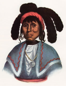
Micanopy, also known as Mick-e-no-páh, Micco-Nuppe, Michenopah, Miccanopa, and Mico-an-opa, and Sint-chakkee, was the leading chief of the Seminole during the Second Seminole War.

Wild Cat, also known as Coacoochee or Cowacoochee (from Creek Kowakkuce "bobcat, wildcat") (c. 1807/1810–1857) was a leading Seminole chieftain during the later stages of the Second Seminole War and the nephew of Micanopy.

The Mala Compra Plantation Archeological Site is an archaeological site in Palm Coast, Florida, on the east bank of the Matanzas River. It is located west of the intersection of State Road A1A and Mala Compra Drive at Bings Landing County Park in Flagler County. On March 5, 2004, it was added to the United States National Register of Historic Places.

The Dade battle was an 1835 military defeat for the United States Army. The U.S. was attempting to force the Seminoles to move away from their land in Florida and relocate to Indian Territory. Amidst a war between the Government of the United States and the Seminole two U.S. Army companies numbering 103 men under the command of Major Francis L. Dade were ambushed by approximately 180 Seminole warriors as they marched from Fort Brooke on Tampa Bay to reinforce Fort King in Ocala. Only three U.S. soldiers survived the attack, and one died of his wounds the following day.
Uchee Billy or Yuchi Billy was a chief of a Yuchi band in Florida during the first half of the 19th century. Uchee Billy's band was living near Lake Miccosukee when Andrew Jackson invaded Spanish Florida during the First Seminole War and attacked the villages in the area. Yuchi Billy and his band then moved to the St. Johns River. During the Second Seminole War, Uchee Billy was an ally of the Seminoles, and was one of the principal war chiefs who fought the U.S. Army.

William Gates was a long serving career United States Army officer who served on active duty from when he entered West Point as a cadet in 1801 until his final retirement in 1867. He was a veteran of the War of 1812, Seminole Wars, the Mexican War and the American Civil War, to which he was called to duty at the age of 73.
The Hernández–Capron Trail also known as the Hernández Trail is a historic trail in Eastern Florida extending between New Smyrna in Volusia County and Fort Pierce in St. Lucie County. It was the first road from St. Augustine to the Fort Pierce area. It was originally cut through the Atlantic Coastal Ridge by Joseph Marion Hernández. The majority of the trail is in wilderness, although some portions traverse developed areas.
Fort Fulton was established on February 21, 1840, between Old Kings Road and Pellicer Creek in present-day Flagler County, Florida. A January 17, 1840 article in the Florida Herald of St. Augustine stated, "Can anyone inform us why the Mounted Volunteer Company, raised in this city, and now stationed at Hewlett’s [Hewitt’s] Mill, is weakened by a detail of ten men subject to the order of the city council, and kept in town idle." This article suggests that Fort Fulton was most likely manned with militia volunteers since it was the only military post in the general area of Hewitt's Mill. Hewitt's Mill was a sawmill built in 1768 by John Hewitt on his 1,000-acre plot of land in St. Johns County. This sawmill is known to have supplied many wooden building materials to the St. Augustine area and surrounding plantations.

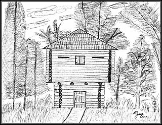
Fort Hanson was a blockhouse fortification built in 1838 by the United States Army as one of a chain of military outposts created during the Second Seminole War. These fortifications were located near vital road and waterway routes, or were built within a day’s journey of one another. Fort Hanson was primarily built for the protection of the St. Augustine area in the Florida Territory. St. Augustine had become refuge for many white settlers and their slaves that had fled from nearby settlements and plantations for safety in the city. In addition to St. Augustine being an important shipping port and supply center for the war effort the additional civilians made the city a key stronghold requiring a substantial military presence for its defense. The fort originally stood about thirteen miles southwest of St. Augustine.
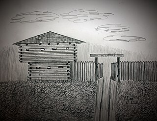
Fort Gardiner was a stockaded fortification with two blockhouses that was built in 1837 by the United States Army. It was one of the military outposts created during the Second Seminole War to assist Colonel Zachary Taylor's troops to capture Seminole Indians and their allies in the central part of the Florida Territory that were resisting forced removal to federal territory west of the Mississippi River per the Indian Removal Act.

Fort Basinger's original site is located approximately 35 miles (56 km) west of Fort Pierce, Florida, along U. S. Highway 98 in Highlands County, Florida. It was a stockaded fortification with two blockhouses that was built in 1837 by the United States Army. It was one of the military outposts created during the Second Seminole War to assist Colonel Zachary Taylor's troops to confront and capture Seminole Indians and their allies in the central part of the Florida Territory in the Lake Okeechobee region. The Seminole Indians and their allies were resisting forced removal to federal territory west of the Mississippi River as directed by the Indian Removal Act.
Gad Humphreys was an officer in the United States Army and an Indian agent in Florida. He was appointed to his post in 1822. He was supportive of the Indians and tried to help them and protect them from encroachments by White settlers. He was accused of abusing his post by preventing or delaying the return to their owners of fugitive slaves that had taken refuge with the Indians. An investigation was conducted, but none of his accusers were willing to testify. Even so, he was removed from his post in 1830.


