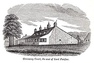
Greenway Court is a historic country estate near White Post in rural Clarke County, Virginia. The property is the site of the seat of the vast 18th-century land empire of Thomas Fairfax, 6th Lord Fairfax of Cameron (1693–1781), the only ennobled British colonial proprietor to live in one of the North American colonies. The surviving remnants of his complex — a later replacement brick house and Fairfax's stone land office — were designated a National Historic Landmark in 1960.

The Southwest Virginia Museum Historical State Park is a Virginia museum, run as a state park, dedicated to preserving the history of the southwestern part of the commonwealth. It is located in Big Stone Gap, in a house built in the 1880s for former Virginia Attorney General, Rufus A. Ayers. It was designed and built by Charles A. Johnson. Construction began in 1888 and was completed in 1895.

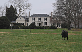
Belle Grove Plantation is a late-18th-century plantation house and estate in the northern Shenandoah Valley of Virginia, USA. It is situated in Frederick County, about a mile southwest of Middletown.

Muddy Creek Mill is a historic grist mill complex and national historic district located in Tamworth, Cumberland County, Virginia. The district encompasses five contributing buildings and three contributing sites. The mill was built between 1785 and 1792, and is a large two-story structure with two half stories and rests on a down slope basement. It is constructed of sandstone, rubble masonry, and brick. Associated with the mill are a contributing brick store, early-19th century frame miller's house, late-18th century farmhouse and dairy, and the sites of a cooper's shop, blacksmith's shop and saw mill.

Walnut Grove is an historic Greek Revival-style house in Spotsylvania County, Virginia. The house was built in 1840 on land that was purchased by Jonathan Johnson in 1829. Markings on the exposed oak beams indicate that Walnut Grove was built by William A. Jennings. Jennings was recognized as a master builder of Greek Revival homes during that period. Walnut Grove was added to the National Register of Historic Places in August 2004.

Edgemont, also known as Cocke Farm, is a historic home located near Covesville, Albemarle County, Virginia. It was built about 1796, and is a one- to two-story, three-bay, frame structure in the Jeffersonian style. It measures 50 feet by 50 feet, and sits on a stuccoed stone exposed basement. The house is topped by a hipped roof surmounted by four slender chimneys. The entrances feature pedimented Tuscan order portico that consists of Tuscan columns supporting a full entablature. Also on the property is a rubble stone garden outbuilding with a hipped roof. The house was restored in 1948 by Charlottesville architect Milton Grigg (1905–1982). Its design closely resembles Folly near Staunton, Virginia.

Limestone, also known as Limestone Plantation and Limestone Farm, has two historic homes and a farm complex located near Keswick, Albemarle County, Virginia. The main dwelling at Limestone Farm consists of a long, narrow two-story central section flanked by two wings. the main section was built about 1840, and the wings appear to be two small late-18th-century dwellings that were incorporated into the larger building. It features a two-story porch. The house underwent another major renovation in the 1920s, when Colonial Revival-style detailing was added. The second dwelling is the Robert Sharp House, also known as the Monroe Law Office. It was built in 1794, and is a 2+1⁄2-story, brick and frame structure measuring 18 feet by 24 feet. Also on the property are a contributing shed (garage), corncrib, cemetery, a portion of a historic roadway, and a lime kiln known as "Jefferson's Limestone Kiln" (1760s). Limestone's owner in the late-18th century, Robert Sharp, was a neighbor and acquaintance of Thomas Jefferson. The property was purchased by James Monroe in 1816, after the death of Robert Sharp in 1808, and he put his brother Andrew Monroe in charge of its administration. The property was sold at auction in 1828.

Long Marsh Run Rural Historic District is a national historic district located just outside Berryville, in Clarke County, Virginia. It encompasses 315 contributing buildings, 16 contributing sites, and 35 contributing structures. The district includes the agricultural landscape and architectural resources of an area distinctively rural that contains numerous large antebellum and postbellum estates, and several smaller 19th-century farms, churches, schools and African-American communities.

Mill House, also known as Chinn's Mill and Hatcher's Mill, is a historic grist mill complex located near Middleburg, Fauquier County, Virginia. All of the buildings in the complex are constructed of stone laid in a random-rubble pattern and some are of mixed stone and frame construction. They represent a late 18th- to early 19th-century rural Virginia grist mill operation, that was later transformed during the early-20th-century into a "hunt country" estate by John Shaffer Phipps. In addition to the mill itself, the complex includes the miller's house, the cooper's house and shop, the mill owner's house, and what was likely a dairy/smokehouse.

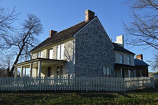
John Hite House, also known as Springdale, is a historic home located at Bartonsville, Frederick County, Virginia. The original house was built in 1753, and is of native limestone laid in irregular ashlar with some random-coursed limestone rubble used on its secondary walls. The stone was quarried from a nearby field. The house faced east, overlooking the Indian Trail/Great Valley Road, where Jost Hite's tavern was situated at the ford of the Opequon Creek. The Springdale property was originally the home of Jost Hite, the earliest white settler in the lower Shenandoah Valley. Jost Hite was Pennsylvania Dutch and moved to the Valley in August 1731. His son, Colonel John I. Hite, built the Springdale house. Also on the property are the contributing stone ruins of what is believed to be Jost Hite's tavern/house of the 1730s, a stone shed, and small wood-frame spring house. The house and 288 acres were sold March 20, 1802 to Richard Peters Barton (1763-1821), a native of Lancaster Pa. who had spent some years in Dinwiddie County, Va., before moving to Frederick County c. 1798. [Frederick County Deed Book S.C.4, p. 484.] The house passed to his son Richard Walker Barton (1799-1859) and in 1858 to another son, David Walker Barton (1801-1863), remaining in the Barton family until 1873. There is a small Barton family cemetery on the property. When the Valley Turnpike was chartered in 1834, the road was laid out to run on the west side of Springdale. Soon thereafter, the house was reoriented to face the Turnpike, and the Richard W. Bartons built the then-fashionable Greek Revival four-bay, two-story portico. [Garland W. Quarles, "Some Old Houses in Frederick County, Virginia", Winchester, 1990. Revised ed. PP. 131–135.]

Old Forge Farm, also known as Zane's Furnace, Stephens Fort, and Marlboro Iron Works, is a historic home and farm located near Middletown, Frederick County, Virginia. The original section dates to the 18th century. The house is a two-story, asymmetrical, three-bay, limestone dwelling with a two-story addition connecting the main house to a one-story former summer kitchen. Also on the property are the contributing 18th century hexagonal ice house of unusual design, an early 20th-century root cellar, privy, and shed. The property was first known as Stephen's Fort, built by Lewis Stephens, son of Peter Stephens, for protection during the French and Indian War. Sold in 1767 to Isaac Zane, whose Zane's Furnace was a major manufacturer of munitions for the Continental Army. Grist mill operations continued into the 1950s.
Millbank is a historic home and archaeological site and national historic district located near Port Conway, King George County, Virginia. It encompasses 1 contributing building, 8 contributing sites, and 1 contributing structure. Among the archaeological sites are the A. Fitzhugh Plantation Site including the smokehouse and chimney / kitchen sites; the Ballentine Site; the Brick Rubble Site; the Nail Field Site; the Old House Swamp Pointe Site; and a probable Mill Site. The current house is an I-house dwelling built about 1900 on a basement dating to the 18th century. The plantation was initially settled in 1669; the land has been the site of residential occupation and agricultural endeavors since that time.

Stover House, also known as Fort Stover, is a historic home located near Luray, Page County, Virginia. It is dated to the late-18th century, and is a two-story, three-bay, rubble stone structure with a traditional Flurkuchenhaus plan. It has a basement that projects its full height above grade on the river side. Located off the basement is a vaulted room. It is considered among the best preserved and least altered of the important group of 18th-century log and stone German houses of the Massanutten Settlement.

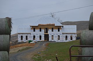
Back Creek Farm is a historic home located near Dublin, Pulaski County, Virginia. It dates to the late-18th century, and is a two-story, five-bay, brick I-house with a side-gable roof. It has a two-story rear ell, sits on a rubble limestone basement, and has interior end chimneys with corbelled caps. The front facade features a pedimented tetrastyle Ionic order porch with an elegant frontispiece doorway with stop-fluted Corinthian order pilasters. Its builder was Joseph Cloyd (1742-1833). During the American Civil War, on May 9, 1864, the Battle of Cloyd's Mountain was fought on the property. The house served that day as a hospital and as headquarters for the Union General George Crook, under whose command were Captains Rutherford B. Hayes and William McKinley.
Daniel Harrison House, also known as Fort Harrison, is a historic home located near Dayton, Rockingham County, Virginia. The original structure was built in 1748 as a two-story, three bay limestone dwelling, with a steep gable roof and wide chimney caps. A brick extension was added in the early 1800s. It was originally surrounded by a palisade and was reported to have an underground passage to the nearby spring. During the French and Indian War, the legislature of Virginia designated the house and surrounding property "Fort Harrison." The house is one of the oldest in the Shenandoah Valley, and is closely associated with the early history of Rockingham County.

Snapp House, also known as Wildflower Farm, is a historic home located near Fishers Hill, Shenandoah County, Virginia. It was built about 1790, and is a two-story Continental log dwelling sheathed in weatherboard. It sits on a limestone basement and has a two-story, rubble limestone rear ell with a central chimney. A small frame structure connects the log section to the rear ell. Also on the property is the contributing site of a spring house.

Hupp House, also known as the Frontier Fort and Hupp Homestead, is a historic home located in Strasburg, Shenandoah County, Virginia. It was built about 1755, and is a 4-story, rubble limestone Colonial-era dwelling. It is on a banked site and measures 20 feet wide by 40 feet deep. A concrete block east wing was added in 1956. The house has a steep gable roof and features a traditional Germanic central chimney and the interior framing appears original, with heavy traditional Germanic beams and roof structure. It is one of the oldest extant dwellings erected by Germanic settlers in Shenandoah County.
George Oscar Thompson House, also known as the Sam Ward Bishop House, was a historic home located near Tazewell, Tazewell County, Virginia. It was built in 1886–1887, and was a two-story, three-bay, T-shaped frame dwelling. It had a foundation of rubble limestone. The front facade featured a one-story porch on the center bay supported by chamfered posts embellished with sawn brackets. Also on the property were a contributing limestone spring house, a one-room log structure, and a 1+1⁄2-story frame structure. Tradition suggests the latter buildings were the first and second houses built by the Thompson family.

White's Mill is a historic grist mill located near Abingdon, Washington County, Virginia. It dates to the mid-19th century, and is a frame two-story structure resting on a down slope basement with a full attic sheltered by a gable roof. It has a Fitz waterwheel and great gear wheel, buhr runs, roller mills, elevators and bolting machinery. Associated with the mill are the contributing earthen race which feeds directly into the wooden race and onto the wheel and an early coursed rubble limestone dam. The mill remains in working condition.

Adam Kurtz House, also known as Washington's Headquarters, is a historic home located at Winchester, Virginia. It was built about 1755, and is of hewn-log construction. It consists of three rooms, with the westernmost room having two of its three exterior walls of stone construction. It sits on a rubble limestone foundation.


 Fort Philip Long historical marker
