Fort Plain is a village in Montgomery County, New York, United States. As of the 2010 census, the village population was 2,322. The village is named after a fort built during the American Revolution at the junction of the Mohawk River and its tributary Otsquago Creek.
Battleford is a town located across the North Saskatchewan River from the City of North Battleford, in Saskatchewan, Canada.

Bent's Old Fort is an 1833 fort located in Otero County in southeastern Colorado, United States. A company owned by Charles Bent and William Bent and Ceran St. Vrain built the fort to trade with Southern Cheyenne and Arapaho Plains Indians and trappers for buffalo robes. For much of its 16-year history, the fort was the only major white American permanent settlement on the Santa Fe Trail between Missouri and the Mexican settlements. It was destroyed in 1849.

There are 461 properties and historic districts listed on the National Register of Historic Places in North Dakota. There are listings in 52 of North Dakota's 53 counties.

Fort Gibson is a historic military site next to the modern city of Fort Gibson, in Muskogee County Oklahoma. It guarded the American frontier in Indian Territory from 1824 to 1888. When it was constructed, the fort was farther west than any other military post in the United States. It formed part of the north–south chain of forts that was intended to maintain peace on the frontier of the American West and to protect the southwestern border of the Louisiana Purchase. The fort succeeded in its peacekeeping mission for more than 50 years, as no massacres or battles occurred there.

Fort Supply was a United States Army post established on November 18, 1868, in Indian Territory to protect the Southern Plains. It was located just east of present-day Fort Supply, Oklahoma, in what was then the Cherokee Outlet.

Fort Fetterman was constructed in 1867 by the United States Army on the Great Plains frontier in Dakota Territory, approximately 11 miles northwest of present-day Douglas, Wyoming. Located high on the bluffs south of the North Platte River, it served as a major base for the start of several United States military expeditions against warring Native American tribes. The fort is listed on the National Register of Historic Places.
Fort C. F. Smith was a military post established in the Powder River country by the United States Army in Montana Territory on August 12, 1866, during Red Cloud's War. Established by order of Col. Henry B. Carrington, it was one of five forts proposed to protect the Bozeman Trail against the Oglala Lakota (Sioux), who saw the trail as a violation of the 1851 Treaty of Fort Laramie. The fort was abandoned in 1868 and burned by the Sioux under Red Cloud.

Fort Omaha, originally known as Sherman Barracks and then Omaha Barracks, is an Indian War-era United States Army supply installation. Located at 5730 North 30th Street, with the entrance at North 30th and Fort Streets in modern-day North Omaha, Nebraska, the facility is primarily occupied by the Metropolitan Community College. A Navy Operational Support Center and Marine Corps Reserve unit, along with an Army Reserve unit occupy the periphery of the 82.5 acres (33.4 ha) fort. The government deeded all but four parcels of the land to the Metropolitan Community College in 1974.
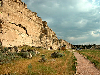
Register Cliff is a sandstone cliff and featured key navigational landmark prominently listed in the 19th century guidebooks about the Oregon Trail, and a place where many emigrants chiseled the names of their families on the soft stones of the cliff — it was one of the key checkpoint landmarks for parties heading west along the Platte River valley west of Fort John, Wyoming which allowed travelers to verify they were on the correct path up to South Pass and not moving into impassable mountain terrains—geographically, it is on the eastern ascent of the Continental Divide leading upward out of the Great Plains in the east of the U.S. state of Wyoming. It is notable as a historic landmark for 'registering' hundreds of emigrants on the Oregon Trail who came to follow custom and inscribed their names on its rocks during the western migrations of the 19th century. An estimated 500,000 emigrants used these trails from 1843 to 1869, with up to one-tenth dying along the way, usually due to disease.
The Fort Laramie Three-Mile Hog Ranch was built to serve as a social center away from the soldiers' post at historic Fort Laramie. Fort Laramie was a 19th-century military post in eastern Wyoming. It became notorious as a place for gambling and drinking, and for prostitution, with at least ten prostitutes always in residence. The location is notable as an example of one of only a few military bordellos still standing in the United States by 1974, the time of its nomination to the National Register of Historic Places The Fort Laramie site was one of a number of so-called "hog ranches" that appeared along trails in Wyoming.

This is a list of the National Register of Historic Places listings in Saline County, Missouri.
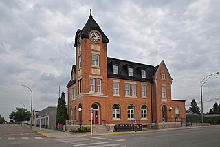
US Post Office-Fort Plain is a historic post office building located at Fort Plain in Montgomery County, New York, United States. It was built in 1931, and is one of a number of post offices in New York State designed by the Office of the Supervising Architect of the Treasury Department under James A. Wetmore. It is a two-story, symmetrical brick building with a one-story rear wing in the Colonial Revival style. It features a shallow projecting frontispiece framed by four brick pilasters and a pair of Grecian style lamps with glass globes.

St. James Catholic Church and Cemetery, also known as St. James at Sag Bridge Church is a historic church and cemetery in the Sag Bridge area of the village of Lemont, Illinois. It is situated on a high bluff at the western tip of the glacier-carved Mount Forest Island, overlooking the Calumet Sag Channel and the community of Sag Bridge.

The Fort Leaton State Historic Site is located on Farm to Market Road 170, in Presidio County in the U.S. state of Texas. The original adobe structure was a private residence dating back to the early 19th century. It was purchased in 1848 by Benjamin Leaton, who adapted it as a fortress. Fort Leaton was the Presidio County original seat of government. Through murders, financial difficulties and abandonment, the structure changed hands numerous times. In 1967, it was deeded to the state of Texas and opened to the public in 1978 as a Texas State Historic Site. It was added to the National Register of Historic Places listings in Presidio County, Texas on June 18, 1973.
