The Western Region is located in south Ghana, spreads from the Ivory Coast in the west to the Central region in the east, includes the capital and large twin city of Sekondi-Takoradi on the coast, coastal Axim, and a hilly inland area including Elubo. It includes Ghana's southernmost location, Cape Three Points, where crude oil was discovered in commercial quantities in June 2007. The region covers an area of 13,842 km2, and had a population of 2,060,585 at the 2021 Census.
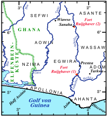
The Ankobra River is situated in southwest Ghana. Starting north east of Wiawso, it flows about 190 kilometres (120 mi) south to the Gulf of Guinea, and enters the ocean about 60 km to the west of the city of Takoradi. Near its mouth are the remains of Fort Elize Carthago, a Dutch trading post abandoned in 1711.

Elmina Castle was erected by the Portuguese in 1482 as Castelo de São Jorge da Mina, also known as Castelo da Mina or simply Mina, in present-day Elmina, Ghana, formerly the Gold Coast. It was the first trading post built on the Gulf of Guinea, and the oldest European building in existence south of the Sahara.
John Canoe, also known as January Conny, was the European name given to an Akan warrior from Axim, Ghana. He was a chief of the Ahanta people in the early 18th century, who established a stronghold in the defunct Fort Fredericksburg and fought multiple wars with European traders for twenty years. The stronghold finally fell in 1725, though Canoe's fate is unknown. He is commemorated in the Junkanoo festival held in the Caribbean each December.

The Dutch Gold Coast or Dutch Guinea, officially Dutch possessions on the Coast of Guinea was a portion of contemporary Ghana that was gradually colonized by the Dutch, beginning in 1612. The Dutch began trading in the area around 1598, joining the Portuguese which had a trading post there since the late 1400s. Eventually, the Dutch Gold Coast became the most important Dutch colony in West Africa after Fort Elmina was captured from the Portuguese in 1637, but fell into disarray after the abolition of the slave trade in the early 19th century. On 6 April 1872, the Dutch Gold Coast was, in accordance with the Anglo-Dutch Treaties of 1870–71, ceded to the United Kingdom.

The Treaty of Butre between the Netherlands and Ahanta was signed at Butre, Dutch Gold Coast on 27 August 1656. The treaty regulated the jurisdiction of the Netherlands and the Dutch West India Company over the town of Butre and the surrounding country of Upper Ahanta, creating a Dutch protectorate over the area, and permitting the establishment of Fort Batenstein. The treaty lasted until the Dutch departure from the Gold Coast in April 1872.

The Treaty of Axim was concluded between the Netherlands and the chiefs of Axim in the western region of the Gold Coast and signed at Fort St. Anthony near Axim on 17 February 1642. The treaty regulated the jurisdiction of the Netherlands and the Dutch West India Company in the town and polity of Axim after the Dutch West India Company had successfully attacked the Portuguese who were the occupants of Fort St. Anthony in the town. Over time, the agreement was in part superseded and replaced by new contracts and agreements. The treaty did remain the basis for Dutch jurisdiction and political relations between Axim and the Dutch until the latter left the Gold Coast in 1872.
The Ahanta/Ayinda are Akan People who live to the north and east of the Nzema. The Ahanta land has been historically known as one of the richest areas on the coast of what is now Ghana.
Fort Saint Anthony was a fort built by the Portuguese in 1515 near the town of Axim, in what is now Ghana. In 1642, the Dutch captured the fort and subsequently made it part of the Dutch Gold Coast. The Dutch expanded the fort considerably before they turned it over, with the rest of their colony, to the British in 1872. The fort is now the property of the Ghanaian state and is open to the public.
Ussher Fort is a fort in Accra, Ghana. It was built by the Dutch in 1649 as Fort Crèvecœur, and is two days' march from Elmina and to the east of Accra on a rocky point between two lagoons. It was one of three forts that Europeans built in the region during the middle of the 17th century. Fort Crèvecœur was part of the Dutch Gold Coast. The Anglo-Dutch Gold Coast Treaty (1867), which defined areas of influence on the Gold Coast, transferred it to the British in 1868. Because of its significance in the history of European colonial trade and exploitation in Africa, the fort was inscribed on the UNESCO World Heritage List in 1979.

Fort Batenstein was a fort and trading post established by the Dutch on the Gold Coast in 1656. It was situated near Butre. The fort was ceded with the entire Dutch Gold Coast to Britain in 1872.

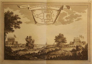
Fort Metal Cross, originally Fort Dixcove, is a military structure located on a promontory at the fishing community of Infuma in Dixcove, in the Western Region of Ghana. Because of its history in the Atlantic slave trade and its testimony to European-African trade, the Fort was included as one of the Forts and Castles of Volta, Greater Accra, Central and Western Regions that became a World Heritage Site in 1979.
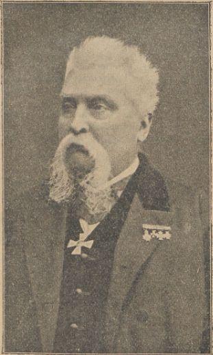
Cornelis Johannes Marius Nagtglas was a Dutch politician and civil servant, who made a career in the administration on the Dutch Gold Coast. After originally beginning his career at the advanced age of 36, he was promoted through the ranks to eventually become Governor of the Dutch Gold Coast in 1858. He retired to the Netherlands in 1862, but returned to the Gold Coast as governor in 1869, to restore order in the embattled colony. In 1871, he left the Gold Coast again, one year before the transfer of the colony to the United Kingdom.
Pieter Woortman was a slave trader and an administrator of the Dutch West India Company. He was one of the longest-serving Director-General of the Dutch Gold Coast, in office between 1767 and 1769 and from 1769 until his death in 1780.
The Dutch–Ahanta War was a conflict between the Netherlands and the Ahanta between 1837 and 1839. Beginning with a mere economic dispute between the Ahanta and the Dutch, who were based at the Dutch Gold Coast, the conflict ended with the hanging of Ahanta king Badu Bonsu II and the reorganization of the Ahanta state, establishing a Dutch protectorate over the Ahanta.
The Treaty of Asebu was concluded in 1612 between the Dutch Republic and the chiefs of Asebu on the Gold Coast of Africa. The treaty was the first among several concluded between the Dutch and the peoples of the Gold Coast, and marked the beginning of a 260-year period of Dutch presence on the Gold Coast.
The Kingdom of the Netherlands has an embassy in the Republic of Ghana. It has a role in promoting trade between the countries.

Fort Elize Carthago was a fort built by the Dutch West India Company in 1702 on a hill at the mouth of the Ankobra River, near the base of the Dutch on the Western Gold Coast, Fort Saint Anthony. Today, only ruins of the former fort can be found. The ruins are easily accessible by a pathway from the Ankobra Beach Hotel and are frequented by tourists who enjoy the panoramic view of the site.
Hubertus Varlet was a Dutch architect and colonial administrator, who served on the Dutch Gold Coast. In his capacity as master of works and stores, he rebuilt Fort Crèvecoeur in Accra in 1839. Following the promotion of Anthony van der Eb to governor of the Dutch Gold Coast, Varlet succeeded him as the second vice governor for the Ahanta protectorate, which the Dutch had proclaimed following the conclusion of the Dutch–Ahanta War.