
The Clark Fork, or the Clark Fork of the Columbia River, is a river in the U.S. states of Montana and Idaho, approximately 310 miles (500 km) long. The largest river by volume in Montana, it drains an extensive region of the Rocky Mountains in western Montana and northern Idaho in the watershed of the Columbia River. The river flows northwest through a long valley at the base of the Cabinet Mountains and empties into Lake Pend Oreille in the Idaho Panhandle. The Pend Oreille River in Idaho, Washington, and British Columbia, Canada which drains the lake to the Columbia in Washington, is sometimes included as part of the Clark Fork, giving it a total length of 479 miles (771 km), with a drainage area of 25,820 square miles (66,900 km2). In its upper 20 miles (32 km) in Montana near Butte, it is known as Silver Bow Creek. Interstate 90 follows much of the upper course of the river from Butte to Saint Regis. The highest point within the river's watershed is Mount Evans at 10,641 feet (3,243 m) in Deer Lodge County, Montana along the Continental Divide.

The Pend Oreille River is a tributary of the Columbia River, approximately 130 miles (209 km) long, in northern Idaho and northeastern Washington in the United States, as well as southeastern British Columbia in Canada. In its passage through British Columbia its name is spelled Pend-d'Oreille River. It drains a scenic area of the Rocky Mountains along the U.S.-Canada border on the east side of the Columbia. The river is sometimes defined as the lower part of the Clark Fork, which rises in western Montana. The river drains an area of 66,800 square kilometres (25,792 sq mi), mostly through the Clark Fork and its tributaries in western Montana and including a portion of the Flathead River in southeastern British Columbia. The full drainage basin of the river and its tributaries accounts for 43% of the entire Columbia River Basin above the confluence with the Columbia. The total area of the Pend Oreille basin is just under 10% of the entire 258,000-square-mile (670,000 km2) Columbia Basin. Box Canyon Dam is currently underway on a multimillion-dollar project for a fish ladder.

The Kootenay is a major river in the Northwest Plateau, within the borders of southeastern British Columbia, Canada, and northern Montana and Idaho in the United States. It is one of the uppermost major tributaries of the Columbia River, the largest North American river that empties into the Pacific Ocean. The Kootenay River runs 781 kilometres (485 mi) from its headwaters in the Kootenay Ranges of the Canadian Rockies, flowing from British Columbia's East Kootenay region into northwestern Montana, then west into the northernmost Idaho Panhandle and returning to British Columbia in the West Kootenay region, where it joins the Columbia at Castlegar.

York Factory was a settlement and Hudson's Bay Company (HBC) factory located on the southwestern shore of Hudson Bay in northeastern Manitoba, Canada, at the mouth of the Hayes River, approximately 200 kilometres (120 mi) south-southeast of Churchill. York Factory was one of the first fur-trading posts established by the HBC, built in 1684 and used in that business for more than 270 years. The settlement was headquarters of the HBC's Northern Department from 1821 to 1873. The complex was designated a National Historic Site of Canada in 1936.

The Pend d’Oreille, also known as the Kalispel, are Indigenous peoples of the Northwest Plateau. Today many of them live in Montana and eastern Washington. The Kalispel peoples referred to their primary tribal range as Kaniksu.

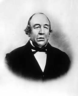
Sir George Simpson was a Scottish explorer and colonial governor of the Hudson's Bay Company during the period of its greatest power. From 1820 to 1860, he was in practice, if not in law, the British viceroy for the whole of Rupert's Land, an enormous territory in northern North America.
New Caledonia was a fur-trading district of the Hudson's Bay Company that comprised the territory of the north-central portions of present-day British Columbia, Canada. Though not a British colony, New Caledonia was part of the British claim to North America. Its administrative centre was Fort St. James. The rest of what is now mainland British Columbia was called the Columbia Department by the British, and the Oregon Country by the Americans. Even before the partition of the Columbia Department by the Oregon Treaty in 1846, New Caledonia was often used to describe anywhere on the mainland not in the Columbia Department, such as Fort Langley in the Fraser Valley.
John Work was a Chief Factor of the Hudson's Bay Company and head of one of the original founding families in Victoria, British Columbia. Work joined the Hudson's Bay Company in 1814 and served in many capacities until his death in 1861, ultimately becoming a member of the company's Board of Management for its Western Department. He also served on Vancouver Island’s Legislative Council. At the time of his death, Work was the largest private land owner of Vancouver Island. Work left an important legacy in the form of sixteen journals which chronicle his trading expeditions from 1823 to 1851. His journals provide a detailed record of Pacific Northwest land features, native peoples, and the Hudson’s Bay Company’s fur trading business in the early 19th century.
The trade center Fort Colvile was built by the Hudson's Bay Company (HBC) at Kettle Falls on the Columbia River in 1825 and operated in the Columbia fur district of the company. Named for Andrew Colvile, a London governor of the HBC, the fort was a few miles west of the present site of Colville, Washington. It was an important stop on the York Factory Express trade route to London via the Hudson Bay. The HBC for some time considered Fort Colvile second in importance only to Fort Vancouver, near the mouth of the Columbia, until the foundation of Fort Victoria.
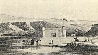
Kullyspell House was a fur trading post established in 1809 on Lake Pend Oreille in what is now North Idaho. It was built by Finan McDonald under the direction of David Thompson of the North West Company.
Saleesh House, also known as Flathead Post, was a North West Company fur trading post built near present-day Thompson Falls, Montana in 1809 by David Thompson and James McMillan of the North West Company. It became a Hudson's Bay Company (HBC) post after that company merged with the North West Company in 1821. Under HBC control the post was better known as Flathead rather than Saleesh. It continued to operate until at least 1855.

The Columbia District was a fur trading district in the Pacific Northwest region of British North America in the 19th century. Much of its territory overlapped with the disputed Oregon Country. It was explored by the North West Company between 1793 and 1811, and established as an operating fur district around 1810. The North West Company was absorbed into the Hudson's Bay Company in 1821 under which the Columbia District became known as the Columbia Department. The Oregon Treaty of 1846 marked the effective end of the Hudson's Bay Company's Columbia Department.
The International Selkirk Loop is a 280-mile-long (450 km) scenic highway in the U.S. states of Idaho and Washington, as well as the Canadian province of British Columbia. The loop encircles the Selkirk Mountain Range, and offers several side trips aside from the main route. Included on the loop is the Kootenay Lake Ferry, the longest free ferry in the world. The portion of the loop in the United States has been designated an All-American Road by the United States Department of Transportation.

State Route 31 (SR 31) is a Washington state highway located entirely in Pend Oreille County. The highway, which is 26.79 miles (43.11 km) long, starts at an intersection with SR 20 in Tiger and travels north to the Canada–US border north of Metaline Falls. At the border, SR 31 becomes British Columbia Highway 6 (BC 6). The route parallels the Pend Oreille River for most of its route and the primary functions of the highway is to serve and connect Tiger, Ione, Metaline and Metaline Falls with British Columbia.
Fort Nez Percés, later known as (Old) Fort Walla Walla, was a fortified fur trading post on the Columbia River on the territory of modern-day Wallula, Washington. Despite being named after the Nez Perce people, the fort was in the traditional lands of the Walla Walla. Founded in 1818 by the North-West Company, after 1821 it was run by the Hudson's Bay Company until its closure in 1857.
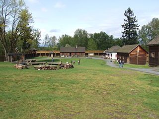
Fort Langley National Historic Site, commonly shortened to Fort Langley, is a former fur trading post of the Hudson's Bay Company in the community of Fort Langley of Langley, British Columbia, Canada. The national historic site sits above the banks of the Bedford Channel across McMillan Island. The national historic site contains a visitor centre and a largely reconstructed trading post that contains ten structures surrounded by wooden palisades.

The Dewdney Trail is a 720 km (450 mi) trail in British Columbia, Canada that served as a major thoroughfare in mid-19th century British Columbia. The trail was a critical factor in the development and strengthening of the newly established British Colony of British Columbia, tying together mining camps and small towns that were springing up along the route during the gold rush era prior to the colony's joining Canadian Confederation in 1871. The route's importance and urgency was prompted because many new gold finds were occurring at locations near the US border that were much more easily accessed from Washington Territory than via any practicable route from the barely settled parts of the Lower Mainland and Cariboo. Today, approximately 80 percent of the former trail has been incorporated into the Crowsnest Highway.

The York Factory Express, usually called "the Express" and also the Columbia Express and the Communication, was a 19th-century fur brigade operated by the Hudson's Bay Company (HBC). Roughly 4,200 kilometres (2,600 mi) in length, it was the main overland connection between HBC headquarters at York Factory and the principal depot of the Columbia Department, Fort Vancouver.

James Sinclair (1811–1856) was a trader and explorer with the Hudson's Bay Company (HBC). He twice led large parties of settlers from the Red River colony to the Columbia River valley. These were both authorized by the HBC as a part of grandiose plans to strengthen British claims in the Oregon boundary dispute.

The Boundary-Waneta Border Crossing connects the town of Northport, Washington with Trail, British Columbia on the Canada–US border. Access is via Waneta Road on the American side and British Columbia Highway 22A on the Canadian side. Canada has operated a customs office at or near this crossing since 1865, initially to inspect vessels arriving via the Columbia River, then to inspect trains with the completion of the Nelson and Fort Sheppard Railway (N&FS) in 1893.
