Related Research Articles

The Indian Territory and the Indian Territories are terms that generally described an evolving land area set aside by the United States government for the relocation of Native Americans who held original Indian title to their land as a sovereign independent state. The tribes ceded land they occupied in exchange for land grants in 1803. The concept of an Indian Territory was an outcome of the U.S. federal government's 18th- and 19th-century policy of Indian removal. After the American Civil War (1861–1865), the policy of the U.S. government was one of assimilation.

Sequoyah County is a county located in the U.S. state of Oklahoma. As of the 2020 census, the population was 39,281. The county seat is Sallisaw. Sequoyah County was created in 1907 when Oklahoma became a state. It was named after Sequoyah, who created the Cherokee syllabary and its written language.

Fort Gibson is a town in Cherokee and Muskogee counties in the U.S. state of Oklahoma. The population was 4,154 at the 2010 census, an increase of 2.5 percent over the figure of 4,054 recorded in 2000. It is the location of Fort Gibson Historical Site and Fort Gibson National Cemetery and is located near the end of the Cherokees' Trail of Tears at Tahlequah.
Elias Cornelius Boudinot was an American politician, lawyer, newspaper editor, and co-founder of the Arkansan who served as the delegate to the Confederate States House of Representatives representing the Cherokee Nation. Prior to this he served as an officer of the Confederate States Army in the Trans-Mississippi Theater of the American Civil War. He was the first Native American lawyer permitted to practice before the U.S. Supreme Court.

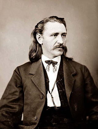
Brigadier-General Stand Watie, also known as Standhope Uwatie, Tawkertawker, and Isaac S. Watie, was a Cherokee politician who served as the second principal chief of the Cherokee Nation from 1862 to 1866. The Cherokee Nation allied with the Confederate States during the American Civil War and he was the only Native American Confederate general officer of the war. Watie commanded Indian forces in the Trans-Mississippi Theater, made up mostly of Cherokee, Muskogee, and Seminole. He was the last Confederate States Army general to surrender.

Major Ridge, The Ridge was a Cherokee leader, a member of the tribal council, and a lawmaker. As a warrior, he fought in the Cherokee–American wars against American frontiersmen. Later, Major Ridge led the Cherokee in alliances with General Andrew Jackson and the United States in the Creek and Seminole wars of the early 19th century.

The Treaty of New Echota was a treaty signed on December 29, 1835, in New Echota, Georgia, by officials of the United States government and representatives of a minority Cherokee political faction, the Treaty Party.
Willstown was an important Cherokee town of the late 18th and early 19th century, located in the southwesternmost part of the Cherokee Nation, in what is now DeKalb County, Alabama. It was near Lookout or Little Wills Creek.
The Battle of Claremore Mound, also known as the Battle of the Strawberry Moon, or the Claremore Mound Massacre, was one of the chief battles of the war between the Osage and Cherokee Indians. It occurred in June 1817, when a band of Western Cherokee and their allies under Chief Spring Frog (Too-an-tuh) attacked Pasuga, an Osage village at the foot of Claremore Mound. The village was nearly empty; only women, children, and the very sick and elderly remained there. Most of the village was currently away on a seasonal hunt that often lasted up to three or four months. The Cherokee killed or captured every remaining member of Chief Clermont's band and destroyed everything they could not carry away. Historians consider it one of the bloodiest Native American massacres in modern history.

Fort Gibson is a historic military site next to the modern city of Fort Gibson, in Muskogee County Oklahoma. It guarded the American frontier in Indian Territory from 1824 to 1888. When it was constructed, the fort was farther west than any other military post in the United States. It formed part of the north–south chain of forts that was intended to maintain peace on the frontier of the American West and to protect the southwestern border of the Louisiana Purchase. The fort succeeded in its peacekeeping mission for more than 50 years, as no massacres or battles occurred there.
The trans-Mississippi theater of the American Civil War was the scene of the major military operations west of the Mississippi River. The area is often thought of as excluding the states and territories bordering the Pacific Ocean, which formed the Pacific coast theater of the American Civil War (1861–1865).
The Battle of Old Fort Wayne, also known as Maysville, Beattie's Prairie, or Beaty's Prairie, was an American Civil War battle on October 22, 1862, in Delaware County in what is now eastern Oklahoma.

The 1st Cherokee Mounted Rifles was a Confederate States Army regiment which fought in the Indian Territory during the American Civil War. It was formed from the merger of two predecessor units the First Regiment of Cherokee Mounted Rifles, and the Second Regiment of Cherokee Mounted Rifles. The first commander was Col. John Drew, while the second was Stand Watie.
The Battle of Middle Boggy, also known as the 'Battle of Middle Boggy River or Battle of Middle Boggy Depot, took place on February 13, 1864 in Choctaw Indian Territory, 4 miles (6.4 km) south of what is now Allen in Pontotoc County, Oklahoma. Advancing down the Dragoon Trail toward Fort Washita, Union Colonel William A. Phillips sent out an advance of approximately 350 men from the 14th Kansas Cavalry and two howitzers to attack a Confederate outpost guarding the Trail's crossing of Middle Boggy River. The Confederate force was led by Captain Jonathan Nail and composed of one company of the First Choctaw and Chickasaw Cavalry, a detachment of the 20th Texas Cavalry and part of the Seminole Battalion of Mounted Rifles. The outpost was about 12 miles (19 km) from Muddy Boggy Depot, which was held by the Confederates. The Encyclopedia of Oklahoma History and Culture says that the battlefield was 15 miles northeast of the depot, whereas the battlefield marker says the distance was 12 miles. The Confederate force at the outpost, consisting of 90 poorly armed men, were caught off guard when Willetts attacked them. Outnumbered and outgunned, the Confederates held off the Union cavalry attack for approximately 30 minutes before retreating to the rest of Lt. Col. John Jumper's Seminole Battalion, who were not at the main skirmish. The Confederates retreated 45 miles (72 km) southwest down the Dragoon Trail. The Union advance continued south toward Ft. Washita the next day, but when the expected reinforcements did not arrive Philips' Expedition into Indian Territory stalled on February 15, near old Stonewall.

During the American Civil War, most of what is now the U.S. state of Oklahoma was designated as the Indian Territory. It served as an unorganized region that had been set aside specifically for Native American tribes and was occupied mostly by tribes which had been removed from their ancestral lands in the Southeastern United States following the Indian Removal Act of 1830. As part of the Trans-Mississippi Theater, the Indian Territory was the scene of numerous skirmishes and seven officially recognized battles involving both Native American units allied with the Confederate States of America and Native Americans loyal to the United States government, as well as other Union and Confederate troops.

John Martin Thompson (1829–1907) was a lumberman, Native American tribal and civic leader, born in the old Cherokee Nation prior to removal in what is now Bartow County, Georgia, USA. He was the son of Benjamin Franklin Thompson, a South Carolinian of Scot-Irish descent, and Annie Martin, a mix blood Cherokee. She was the daughter of Judge John Martin, the first Chief Justice of the Cherokee Nation and Nellie McDaniel.
Fort McCulloch was a Confederate military fort built by CSA Brigadier General Albert Pike in the Indian Territory during the American Civil War after the Battle of Pea Ridge.
Texas Cherokees were the small settlements of Cherokee people who lived temporarily in what is now Texas, after being forcibly relocated from their homelands, primarily during the time that Spain, and then Mexico, controlled the territory. After the Cherokee War of 1839, the Cherokee communities in Texas were once again forcibly removed to Indian Territory in present-day Oklahoma. When Union troops took control of Cherokee territory in 1863, many "Southern" Cherokees fled to Texas, but after the war, most of them returned to their homes in Indian Territory. Others are part of the multitribal Mount Tabor Indian Community, or Tsalagiyi Nvdagi Tribe which have received commendations for their contributions to the State of Texas.
The Trail of Blood on Ice was a December 1861 campaign in the American Civil War in which pro-Union Native Americans, led by Upper Creek Chief Opothleyahola, fought their way north from Indian Territory to Fort Row, Kansas. They faced continuing attacks from Confederate forces under Col. Douglas H. Cooper.

The ambush of the steamboat J.R. Williams was a military engagement during the American Civil War. It took place on June 15, 1864, on the Arkansas River in the Choctaw Nation which became encompassed by the State of Oklahoma. It is popularly termed the "only naval battle" in that landlocked state. It was a successful Confederate attack on the Union Army's lines of supply. The Confederate forces were Cherokee, Choctaw, Chickasaw and Creek Indians led by General Stand Watie, who was a Cherokee.
References
- ↑ Hitchcock, p. 77 fn.
- ↑ "American Forts:Oklahoma."July 21, 2007. Accessed September 16, 2015.
- 1 2 3 4 May, Jon D. Encyclopedia of Oklahoma History and Culture. "Fort Wayne." Archived 2012-11-19 at the Wayback Machine Retrieved June 15, 2013.