Fortifications of Valletta

Last updated

Fortifications of Valletta
Is-Swar tal-Belt Valletta
Valletta, Malta
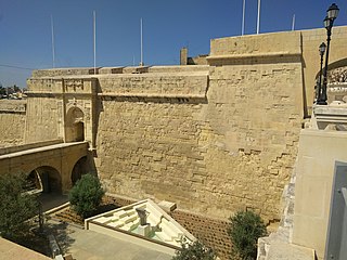
Malta - Valletta - St. Michael's Bastion (Manoel Island) 01 ies.jpg
Valletta Land Front as seen from Manoel Island
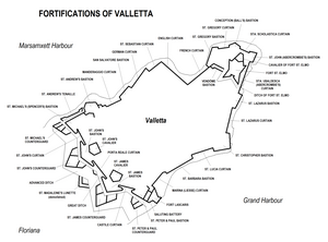
Valletta fortifications map.png
Map of Valletta's fortifications
Malta location map.svg
Red pog.svg
Valletta
Coordinates 35°53′50″N14°30′31.5″E / 35.89722°N 14.508750°E / 35.89722; 14.508750
Type City wall
Site information
Owner Government of Malta
Open to
the public
Yes
ConditionMostly intact
Site history
Built1566–1570s [lower-alpha 1]
Built by Order of Saint John
British Empire (some modifications)
In use1571–1970s
Materials Limestone
Battles/wars French invasion of Malta (1798)
Siege of Malta (1798–1800)
World War II
Events Rising of the Priests
TypeCultural
Criteriai, vi
Designated1980 (4th session)
Part of City of Valletta
Reference no. 131
Region Europe and North America

The fortifications of Valletta (Maltese : Is-Swar tal-Belt Valletta) are a series of defensive walls and other fortifications which surround Valletta, the capital city of Malta. The first fortification to be built was Fort Saint Elmo in 1552, but the fortifications of the city proper began to be built in 1566 when it was founded by Grand Master Jean de Valette. Modifications were made throughout the following centuries, with the last major addition being Fort Lascaris which was completed in 1856. Most of the fortifications remain largely intact today.

Contents

The city of Valletta, along with Nicosia in Cyprus, was considered to be a practical example of an ideal city of the Renaissance, and this was due to its fortifications as well as the urban life within the city. [1] The fortifications were well known throughout Europe by the 17th century, and might have influenced the designs of part of the Fortress of Luxembourg. [2] In an 1878 book, Valletta was described as "one of the best fortified [cities] in the world." [3] Valletta's fortifications are the most important of the fortifications of Malta, [4] and today they form part of a UNESCO World Heritage Site. [5]

History

Background

The construction of a fortified city on the Sciberras Peninsula was first proposed in 1524, when the Order of St. John sent a commission to inspect the Maltese Islands. [6] Back then, the only fortification on the peninsula was a militia watchtower built by the Aragonese in 1488. [7] The tower was strengthened in 1533, but the proposed city was not built since the Order focused on building the fortifications of Birgu, which had become their base. [8]

In 1551, an Ottoman force briefly attacked Malta, and then sacked Gozo and captured Tripoli, and as a result, the Order set up a commission to improve the island's fortifications. In 1552, the Aragonese watchtower was demolished and Fort Saint Elmo was built in its place. The fort played a significant role in the Great Siege of Malta of 1565. It eventually fell after a month of fierce fighting (in which the Ottoman general Dragut was killed). The knights held out in Birgu and Senglea until a relief force arrived, and the siege was lifted.

Construction

After the Order emerged victorious from the siege, it received financial support from Europe, which was used to construct the new capital city on the Sciberras Peninsula. The Italian engineer Francesco Laparelli was sent by the Pope to design the city's fortifications, [9] which were designed along the Italian bastioned system. [10] Laparelli's original design consisted of a bastioned enceinte, with nine cavaliers and a ditch. The city was to be designed along a grid plan, and was to include a naval arsenal and a Manderaggio (a harbour for small ships). [6]

The city's first stone was laid by Grand Master Jean de Valette on 28 March 1566, and the new city was called Valletta in his honour. The city walls were among the first structures to be built within the city, and were largely complete by the 1570s. Some changes were made to the design while the city was being constructed, and only two cavaliers were constructed, while the arsenal and Manderaggio were never built. Fort St. Elmo, which had been severely damaged in the 1565 siege, was also rebuilt and integrated in the city walls. [6]

The city of Valletta officially became the capital city of Malta and the seat of the Order on 18 March 1571, although it was still unfinished. [11] By the end of the 16th century, Valletta was the largest settlement in Malta. [10]

Improvements and modifications

View of Valletta and the Grand Harbour in 1801 GrandHarbourValletta1801.jpg
View of Valletta and the Grand Harbour in 1801

In the 17th and 18th centuries, Valletta's fortifications were strengthened with the construction of various outworks, consisting of four counterguards along the land front, as well as a covertway and a glacis. The northern end of the peninsula, including Fort St. Elmo, was also enclosed in a bastioned enceinte (known as the Carafa Enceinte) in the late 1680s to prevent a landing from the sea. [7]

Despite the modifications, it was realized that the walls of Valletta were not strong enough to withstand a long siege. In 1635, construction of the Floriana Lines commenced, enclosing Valletta's land front. The Floriana Lines were also modified until the 18th century. Later on, the suburb of Floriana developed in the area between the Floriana Lines and the Valletta Land Front, and it is now a town in its own right. [6]

The flanks of the city were further protected in the 17th and 18th century, with the construction of the Santa Margherita Lines, Cottonera Lines and Fort Ricasoli on the Grand Harbour side, and Fort Manoel and Fort Tigné on the Marsamxett side. [12] Further proposals, including construction of fortifications on Corradino and Ta' Xbiex, were also made but were never implemented. [13]

French occupation and British rule

Porta Reale, constructed in 1853 and demolished in 1964 Goats at Port Real Wellcome L0045092 (cropped).jpg
Porta Reale, constructed in 1853 and demolished in 1964

The fortifications of Valletta first saw use during the French invasion of Malta on 9 June 1798. The Order capitulated only three days later on 12 June, and Valletta and its fortifications were handed over to the French. Upon viewing the fortifications, Napoleon reportedly remarked "I am very glad that they opened the gate for us." [14]

A couple of months after the beginning of the French occupation, the Maltese people rebelled against the French and blockaded them in the Harbour area with British, Neapolitan and Portuguese support. The French managed to hold out in Valletta until September 1800, when General Vaubois capitulated to the British, who took control of the islands. [15]

Various modifications were made to Valletta's fortifications during British rule. The most significant of these was the construction of Fort Lascaris between 1854 and 1856. Other alterations included the addition of batteries and concrete gun emplacements, changes to parapets and their embrasures, and the construction of gunpowder magazines. All three original Hospitaller gateways to Valletta were demolished, and two of them were replaced by larger gates. [16]

The British proposed the demolition of the fortifications a number of times in the 19th century. The first proposal was made by Major-General Henry Pigot at the beginning of the century. [17] In 1853, a proposal was made to demolish Saint James Cavalier to make way for a military hospital. In 1855, Sir John Lysaght Pennefather proposed the construction of a citadel on the high ground of the Sciberras peninsula, on the site of the Valletta Land Front and the surrounding area. [18] In 1872, the demolition of the city's outworks was proposed, while the demolition of the entire land front was suggested in 1882. [6] Eventually, the fortifications were left largely intact, and the only part that was demolished was St. Madeleine's Lunette, which was located near the entrance to the city (on the site now occupied by the Triton Fountain). [19]

The fortifications were eventually decommissioned between the late 19th or early 20th centuries. Some parts, such as Fort St. Elmo, Fort Lascaris and the Saluting Battery, remained in use until after World War II, with Fort St. Elmo being decommissioned in 1972. [20] The fortifications were included on the Antiquities List of 1925. [21]

In the 1960s, the 19th century Porta Reale was demolished to make way for a modern City Gate. [22]

Present day

Restoration works at St. Peter and St. Paul Counterguard in 2013 Malta - Valletta - Triq Girolamo Cassar - Herbert Ganado Gardens+SS Peter and Paul Counterguard 01 ies.jpg
Restoration works at St. Peter and St. Paul Counterguard in 2013

The first plans to restore the fortifications of Valletta, along with those of Birgu, Mdina and the Cittadella, were made in 2006. [23] [24] Restoration started in 2010, with the project being described as "the biggest in a century". Squatters were evicted from public lands around the fortifications. [25] The upper part of Fort Saint Elmo has been restored, while its lower parts have been cleaned up. [26] The Chapel of St. Roche on St. Michael's Counterguard, which was bombed in World War II, was rebuilt in 2014 as part of the restoration. [27]

In 2011, the City Gate which had been built in the 1960s was demolished, and a new City Gate was completed in 2014. [28]

Layout

Land front

Detail from an 1858 painting by Edward Fanshawe, showing the Valletta Land Front Valletta Land Front 1858.jpg
Detail from an 1858 painting by Edward Fanshawe, showing the Valletta Land Front
St. John's Bastion Bastion de San Juan, La Valeta, isla de Malta, Malta, 2021-08-25, DD 228-230 HDR.jpg
St. John's Bastion

The Valletta Land Front is the large bastioned enceinte enclosing the landward approach to the city. It consists of the following: [29]

St. James Counterguard Contraguardia de San Jaime, La Valeta, isla de Malta, Malta, 2021-08-25, DD 178.jpg
St. James Counterguard

The entire land front is surrounded by a deep ditch. [42] Remains of a flanking battery within the ditch were unearthed in 2012. [43]

St. Michael's Counterguard and a place-of-arms on Valletta's covertway, as viewed from St. John's Curtain Malta 230915 Valletta 06.jpg
St. Michael's Counterguard and a place-of-arms on Valletta's covertway, as viewed from St. John's Curtain

The bastions are further protected by the following outworks:

The outworks were surrounded by an advanced ditch, but only a part of it remains since most of it was filled in with rubble. [19]

Marsamxett enceinte

The enceinte along Marsamxett Harbour Valletta-panorama-fromsliema.jpg
The enceinte along Marsamxett Harbour
Gun emplacement on St. Andrew's Bastion Malta - Valletta - Triq Sant Andrija - St. Andrew's Bastion 03 ies.jpg
Gun emplacement on St. Andrew's Bastion

The enceinte along the side facing Marsamxett Harbour starts from St. Michael's Bastion of the Valletta Land Front, and ends at St. Gregory's Bastion of Fort St. Elmo. It consists of the following: [29]

Grand Harbour enceinte

The enceinte along the Grand Harbour Malta Valletta Panorama 12.jpg
The enceinte along the Grand Harbour
St. Christopher Bastion Malta - Valletta - Triq il-Lanca+Xatt il-Barriera+Siege Bell War memorial+Lower Barrakka Gardens (MSTHC) 01 ies.jpg
St. Christopher Bastion

The enceinte along the side facing the Grand Harbour starts from St. Peter and St. Paul Bastion of the Valletta Land Front, and ends at St. Ubaldesca Curtain of Fort St. Elmo. It consists of the following: [29]

Fort Saint Elmo

Fort Saint Elmo with the entrance to Marsamxett to the right Malta Valletta2 tango7174.jpg
Fort Saint Elmo with the entrance to Marsamxett to the right
Left Demi-Bastion of Fort St. Elmo Fuerte de San Telmo, La Valeta, isla de Malta, Malta, 2021-08-25, DD 217.jpg
Left Demi-Bastion of Fort St. Elmo
Right Demi-Bastion of Fort St. Elmo Right Demi-Bastion of Fort St. Elmo.jpeg
Right Demi-Bastion of Fort St. Elmo

Fort Saint Elmo is the oldest part of the city walls, and it commands the entrance to both the Grand Harbour and Marsamxett. The fort and the surrounding area consists of the following: [29]

Some barrack blocks are located in the area between Upper St. Elmo and the Carafa Enceinte.

Further reading

Related Research Articles

<span class="mw-page-title-main">Valletta</span> Capital of Malta

Valletta is the capital city of Malta and one of its 68 council areas. Located between the Grand Harbour to the east and Marsamxett Harbour to the west, its population as of 2021 was 5,157. As Malta’s capital city, it is a commercial centre for shopping, bars, dining, and café life. It is also the southernmost capital of Europe, and at just 0.61 square kilometres (0.24 sq mi), it is the European Union's smallest capital city.

<span class="mw-page-title-main">City Gate (Valletta)</span> Entrance to the city of Valletta, Malta

City Gate is a gate located at the entrance of Valletta, Malta. The present gate, which is the fifth one to have stood on the site, was built between 2011 and 2014 to designs of the Italian architect Renzo Piano.

<span class="mw-page-title-main">Fort Ricasoli</span> Historic fort on Malta

Fort Ricasoli is a bastioned fort in Kalkara, Malta, which was built by the Order of Saint John between 1670 and 1698. The fort occupies a promontory known as Gallows' Point and the north shore of Rinella Bay, commanding the entrance to the Grand Harbour along with Fort Saint Elmo. It is the largest fort in Malta and it has been on the tentative list of UNESCO World Heritage Sites since 1998, as part of the Knights' Fortifications around the Harbours of Malta.

<span class="mw-page-title-main">Fort Manoel</span> Star fort in Gzira, Malta

Fort Manoel is a star fort on Manoel Island in Gżira, Malta. It was built in the 18th century by the Order of Saint John, during the reign of Grand Master António Manoel de Vilhena, after whom it is named. Fort Manoel is located to the north west of Valletta, and commands Marsamxett Harbour and the anchorage of Sliema Creek. The fort is an example of Baroque architecture, and it was designed with both functionality and aesthetics in mind.

<span class="mw-page-title-main">Fort Saint Elmo</span> Star fort in Valletta, Malta

Fort Saint Elmo is a star fort in Valletta, Malta. It stands on the seaward shore of the Sciberras Peninsula that divides Marsamxett Harbour from Grand Harbour, and commands the entrances to both harbours along with Fort Tigné and Fort Ricasoli. It is best known for its role in the Great Siege of Malta in 1565.

<span class="mw-page-title-main">Saint Agatha's Tower</span> Tower in Mellieha, Malta

Saint Agatha's Tower, also known as the Red Tower, Mellieħa Tower or Fort Saint Agatha, is a large bastioned watchtower in Mellieħa, Malta. It was built between 1647 and 1649, as the sixth of the Lascaris towers. The tower's design is completely different from the rest of the Lascaris towers, but it is similar to the earlier Wignacourt towers. St. Agatha's Tower was the last large bastioned tower to be built in Malta.

<span class="mw-page-title-main">Cottonera Lines</span> Line of fortifications in Malta

The Cottonera Lines, also known as the Valperga Lines, are a line of fortifications in Bormla and Birgu, Malta. They were built in the 17th and 18th centuries on higher ground and further outwards than the earlier line of fortifications, known as the Santa Margherita or Firenzuola lines, which also surround Bormla.

<span class="mw-page-title-main">Floriana Lines</span> Line of fortifications in Floriana, Malta

The Floriana Lines are a line of fortifications in Floriana, Malta, which surround the fortifications of Valletta and form the capital city's outer defences. Construction of the lines began in 1636 and they were named after the military engineer who designed them, Pietro Paolo Floriani. The Floriana Lines were modified throughout the course of the 17th and 18th centuries, and they saw use during the French blockade of 1798–1800. Today, the fortifications are still largely intact but rather dilapidated and in need of restoration.

<span class="mw-page-title-main">Cittadella (Gozo)</span> Citadel in Victoria, Gozo, Malta

The Citadel, also known as the Castello, is the citadel of Victoria on the island of Gozo, Malta. The area has been inhabited since the Bronze Age, and the site now occupied by the Cittadella is believed to have been the acropolis of the Punic-Roman city of Gaulos or Glauconis Civitas.

<span class="mw-page-title-main">Fort Chambray</span> Fortress in Malta

Fort Chambray or Fort Chambrai is a bastioned fort located in the precincts of Għajnsielem, on the island of Gozo, Malta. It was built in the mid-18th century by the Order of Saint John, in an area known as Ras it-Tafal, between the port of Mġarr and Xatt l-Aħmar. The fort was meant to be the citadel of a new city which was to replace the Cittadella as the island's capital, but this plan never materialized.

<span class="mw-page-title-main">Lascaris Battery</span>

Lascaris Battery, also known as Fort Lascaris or Lascaris Bastion, is an artillery battery located on the east side of Valletta, Malta. The battery was built by the British in 1854, and it is connected to the earlier St. Peter & Paul Bastion of the Valletta Land Front. In World War II, the Lascaris War Rooms were dug close to the battery, and they served as Britain's secret headquarters for the defence of the island.

<span class="mw-page-title-main">Saint John's Cavalier</span>

Saint John's Cavalier is a 16th-century cavalier in Valletta, Malta, which was built by the Order of St. John. It overlooks St. John's Bastion, a large obtuse-angled bastion forming part of the Valletta Land Front. St. John was one of nine planned cavaliers in the city, although eventually only two were built, the other one being the identical Saint James Cavalier. It was designed by the Italian military engineer Francesco Laparelli, while its construction was overseen by his Maltese assistant Girolamo Cassar.

<span class="mw-page-title-main">Fortifications of Malta</span> Defensive military constructions of the Maltese archipelago

The fortifications of Malta consist of a number of walled cities, citadels, forts, towers, batteries, redoubts, entrenchments and pillboxes. The fortifications were built over hundreds of years, from around 1450 BC to the mid-20th century, and they are a result of the Maltese islands' strategic position and natural harbours, which have made them very desirable for various powers.
<span class="mw-page-title-main">Santa Margherita Lines</span> Line of fortifications in Cospicua, Malta

The Santa Margherita Lines, also known as the Firenzuola Lines, are a line of fortifications in Cospicua, Malta. They were built in the 17th and 18th centuries to protect the land front defences of the cities of Birgu and Senglea. A second line of fortifications, known as the Cottonera Lines, was later built around the Santa Margherita Lines, while the city of Cospicua was founded in the 18th century within the Santa Margherita and Cottonera Lines.

<span class="mw-page-title-main">Fortifications of Mdina</span> Defensive walls in Mdina, Malta

The fortifications of Mdina are a series of defensive walls which surround the former capital city of Mdina, Malta. The city was founded as Maleth by the Phoenicians in around the 8th century BC, and it later became part of the Roman Empire under the name Melite. The ancient city was surrounded by walls, but very few remains of these have survived.
<span class="mw-page-title-main">Fortifications of Birgu</span>

The fortifications of Birgu are a series of defensive walls and other fortifications which surround the city of Birgu, Malta. The first fortification to be built was Fort Saint Angelo in the Middle Ages, and the majority of the fortifications were built between the 16th and 18th centuries by the Order of Saint John. Most of the fortifications remain largely intact today.

<span class="mw-page-title-main">Fortifications of Senglea</span>

The fortifications of Senglea are a series of defensive walls and other fortifications which surround the city of Senglea, Malta. The first fortification to be built was Fort Saint Michael in 1552, and the majority of the fortifications were built over the next decade when it was founded by Grand Master Claude de la Sengle. Modifications continued until the 18th century, but large parts of the fortifications were demolished between the 19th and 20th centuries. Today, all that remain of Senglea's fortifications are the seaward bastions and part of the land front.

<span class="mw-page-title-main">Carlos de Grunenbergh</span>

Carlos de Grunenbergh, also known as Carlo Grunenberg, was a Flemish architect and military engineer active in the late 17th century. He mainly designed fortifications in Sicily and Malta. He was also a member of the Order of Saint John.

<span class="mw-page-title-main">1806 Birgu polverista explosion</span> Accidental detonation of a munitions depot in British Malta

On 18 July 1806, approximately 40,000 lb (18,000 kg) of gunpowder stored in a magazine (polverista) in Birgu, Malta, accidentally detonated. The explosion killed approximately 200 people, including British and Maltese military personnel, and Maltese civilians from Birgu. Parts of the city's fortifications, some naval stores, and many houses were destroyed. The accident was found to be the result of negligence while transferring shells from the magazine.

<span class="mw-page-title-main">Chapel of St Anne, Fort St Elmo</span> Church in Valletta, Malta

The Chapel of St Anne is a Roman Catholic chapel located in Fort Saint Elmo in Valletta, Malta. Its existence was first documented in the late 15th century, and it was incorporated into the fort when the latter was constructed by the Order of St John in the mid-16th century. The chapel's present state dates back to the mid-17th century.

References

  1. Cosmescu, Dragos. "Nicosia". fortified-places.com. Archived from the original on 10 August 2017.
  2. "Luxembourg". fortified-places.com. Archived from the original on 22 February 2015.
  3. Pembroke Fetridge, William (1874). The American Travellers' Guides: Hand-books for Travellers in Europe and the East, Being a Guide Through Great Britain and Ireland, France, Belgium, Holland, Germany, Austria, Italy, Egypt, Syria, Turkey, Greece, Switzerland, Tyrol, Denmark, Norway, Sweden, Russia, Spain, and Portugal. Fetridge & Company. p. 517.
  4. "Malta restores her historic fortifications". Arx – International Journal of Military Architecture and Fortification. 8: 7. July 2011. Retrieved 16 August 2015.
  5. "City of Valletta". UNESCO World Heritage List. Archived from the original on 8 February 2016.
  6. 1 2 3 4 5 Attard, Sonia. "The Valletta Fortifications". aboutmalta.com. Archived from the original on 30 December 2014.
  7. 1 2 "Fort St. Elmo" (PDF). Heritage Malta . Archived from the original (PDF) on 6 December 2013.
  8. Zammit, Vincent (1992). Il-Gran Mastri - Ġabra ta' Tagħrif dwar l-Istorja ta' Malta fi Żmienhom - L-Ewwel Volum 1530-1680 (in Maltese). Valletta: Valletta Publishing & Promotion Co. Ltd. p. 22.
  9. Eccardt, Thomas M. (2005). Secrets of the Seven Smallest States of Europe: Andorra, Liechtenstein, Luxembourg, Malta, Monaco, San Marino, and Vatican City. New York City: Hippocrene Books. p. 235. ISBN   9780781810326.
  10. 1 2 "Valletta – 1566". MilitaryArchitecture.com. Archived from the original on 20 June 2011.
  11. Gaul, Simon (2007). Malta, Gozo & Comino. New Holland Publishers. p. 100. ISBN   9781860113659.[ permanent dead link ]
  12. "Knights' Fortifications around the Harbours of Malta". UNESCO Tentative Lists. Archived from the original on 5 September 2015. Retrieved 11 July 2015.
  13. Spiteri, Stephen C. (2014). "Fort Manoel". ARX Occasional Papers. 4. Retrieved 11 July 2015.
  14. "Valletta – The Fortifications". romeartlover.tripod.com. Archived from the original on 7 April 2020.
  15. "The Conflict for Malta, 1798 – 1802". napoleon-series.org. December 2008. Retrieved 11 July 2015.
  16. "Valletta" (PDF). National Inventory of the Cultural Property of the Maltese Islands. 28 June 2013. Archived from the original (PDF) on 11 June 2015. Retrieved 11 September 2015.
  17. Bonello, Giovanni (18 November 2012). "Let's hide the majestic bastions". Times of Malta . Retrieved 5 October 2014.
  18. "Regimental Hospitals and Military Hospitals of the Malta Garrison". maltarmc.com. British Army Medical Services And the Malta Garrison 1799 – 1979. Archived from the original on 17 November 2015. Retrieved 21 October 2015.
  19. 1 2 3 "Advanced Ditch - Valletta" (PDF). National Inventory of the Cultural Property of the Maltese Islands. 28 June 2013. Archived from the original (PDF) on 13 July 2015. Retrieved 11 July 2015.
  20. Gusman, George R. (5 April 2012). "Fort St Elmo". Times of Malta . Retrieved 11 September 2015.
  21. "Protection of Antiquities Regulations 21st November, 1932 Government Notice 402 of 1932, as Amended by Government Notices 127 of 1935 and 338 of 1939". Malta Environment and Planning Authority . Archived from the original on 19 April 2016.
  22. Attard, Chris (24 August 2008). "The gate triumphant". Times of Malta . Retrieved 11 July 2015.
  23. Zammit, Ninu (12 December 2006). "Restoration of forts and fortifications". Times of Malta . Retrieved 10 June 2015.
  24. "A fortune on fortifications". Times of Malta . 20 June 2008. Retrieved 10 June 2015.
  25. Ameen, Juan (1 February 2010). "Restoration starts on Valletta bastions". Times of Malta . Retrieved 10 June 2015.
  26. "Updated - Upper Fort St Elmo restoration nears completion". Times of Malta . 4 November 2014. Retrieved 10 June 2015.
  27. 1 2 "Counterguard Chapel Reconstructed". MilitaryArchitecture.com. 20 November 2014. Archived from the original on 30 December 2014. Retrieved 10 June 2015.
  28. Calleja, Claudia (6 May 2011). "City Gate bites the dust". Times of Malta . Retrieved 11 July 2015.
  29. 1 2 3 4 Meli, Pavla Antonia (1998). An Introduction to the Hospitaller Military Architecture of Valletta.
  30. Simpson, Donald H. (1958). "Some public monuments of Valletta 1800–1955" (PDF). Melita Historica. 2 (3): 157.
  31. "Windmill St Michael's Bastion 1". The Malta Windmill Database. Retrieved 11 July 2015.
  32. "Windmill St Michael's Bastion 2". The Malta Windmill Database. Retrieved 11 July 2015.
  33. "St Michael Bastion - Valletta" (PDF). National Inventory of the Cultural Property of the Maltese Islands. 28 June 2013. Archived from the original (PDF) on 13 July 2015. Retrieved 11 July 2015.
  34. "St John Curtain - Valletta" (PDF). National Inventory of the Cultural Property of the Maltese Islands. 28 June 2013. Archived from the original (PDF) on 13 July 2015. Retrieved 11 July 2015.
  35. "St John Bastion - Valletta" (PDF). National Inventory of the Cultural Property of the Maltese Islands. 28 June 2013. Archived from the original (PDF) on 13 July 2015. Retrieved 11 July 2015.
  36. "St John Cavalier - Valletta" (PDF). National Inventory of the Cultural Property of the Maltese Islands. 28 June 2013. Archived from the original (PDF) on 13 July 2015. Retrieved 11 July 2015.
  37. "Porta Reale Curtain - Valletta" (PDF). National Inventory of the Cultural Property of the Maltese Islands. 28 June 2013. Archived from the original (PDF) on 2 April 2015. Retrieved 11 July 2015.
  38. "St James Bastion - Valletta" (PDF). National Inventory of the Cultural Property of the Maltese Islands. 28 June 2013. Archived from the original (PDF) on 13 July 2015. Retrieved 11 July 2015.
  39. "St James Cavalier - Valletta" (PDF). National Inventory of the Cultural Property of the Maltese Islands. 28 June 2013. Archived from the original (PDF) on 13 July 2015. Retrieved 11 July 2015.
  40. "Castile Curtain - Valletta" (PDF). National Inventory of the Cultural Property of the Maltese Islands. 28 June 2013. Archived from the original (PDF) on 13 July 2015. Retrieved 11 July 2015.
  41. "SS Peter and Paul Bastion - Valletta" (PDF). National Inventory of the Cultural Property of the Maltese Islands. 28 June 2013. Archived from the original (PDF) on 13 July 2015. Retrieved 11 July 2015.
  42. "Main Ditch - Valletta" (PDF). National Inventory of the Cultural Property of the Maltese Islands. 28 June 2013. Archived from the original (PDF) on 13 July 2015. Retrieved 11 July 2015.
  43. "Flanking battery discovered in Valletta Ditch". MilitaryArchitecture.com. 25 February 2012. Archived from the original on 16 May 2016. Retrieved 11 July 2015.
  44. "St Michael Counterguard - Valletta" (PDF). National Inventory of the Cultural Property of the Maltese Islands. 28 June 2013. Archived from the original (PDF) on 13 July 2015. Retrieved 11 July 2015.
  45. "St John Counterguard - Valletta" (PDF). National Inventory of the Cultural Property of the Maltese Islands. 28 June 2013. Archived from the original (PDF) on 13 July 2015. Retrieved 11 July 2015.
  46. "St James Counterguard - Valletta" (PDF). National Inventory of the Cultural Property of the Maltese Islands. 28 June 2013. Archived from the original (PDF) on 13 July 2015. Retrieved 11 July 2015.
  47. "SS Peter and Paul Counterguard - Valletta" (PDF). National Inventory of the Cultural Property of the Maltese Islands. 28 June 2013. Archived from the original (PDF) on 13 July 2015. Retrieved 11 July 2015.
  48. "St Andrew Tenaille - Valletta" (PDF). National Inventory of the Cultural Property of the Maltese Islands. 28 June 2013. Archived from the original (PDF) on 13 July 2015. Retrieved 11 July 2015.
  49. "St Andrew Bastion - Valletta" (PDF). National Inventory of the Cultural Property of the Maltese Islands. 28 June 2013. Archived from the original (PDF) on 13 July 2015. Retrieved 11 July 2015.
  50. "The lost landmarks of Malta: Ponsonby's Column, Valletta". The Malta Independent . 26 January 2014. Retrieved 11 July 2015.
  51. "Manderaggio Curtain - Valletta" (PDF). National Inventory of the Cultural Property of the Maltese Islands. 28 June 2013. Archived from the original (PDF) on 13 July 2015. Retrieved 11 July 2015.
  52. "San Salvatore Bastion - Valletta" (PDF). National Inventory of the Cultural Property of the Maltese Islands. 28 June 2013. Archived from the original (PDF) on 13 July 2015. Retrieved 11 July 2015.
  53. "German Curtain - Valletta" (PDF). National Inventory of the Cultural Property of the Maltese Islands. 28 June 2013. Archived from the original (PDF) on 13 July 2015. Retrieved 11 July 2015.
  54. "St Sebastian Curtain - Valletta" (PDF). National Inventory of the Cultural Property of the Maltese Islands. 28 June 2013. Archived from the original (PDF) on 13 July 2015. Retrieved 11 July 2015.
  55. "English Curtain - Valletta" (PDF). National Inventory of the Cultural Property of the Maltese Islands. 28 June 2013. Archived from the original (PDF) on 13 July 2015. Retrieved 11 July 2015.
  56. "French Curtain - Valletta" (PDF). National Inventory of the Cultural Property of the Maltese Islands. 28 June 2013. Archived from the original (PDF) on 13 July 2015. Retrieved 11 July 2015.
  57. "Lascaris Battery - Valletta" (PDF). National Inventory of the Cultural Property of the Maltese Islands. 28 June 2013. Archived from the original (PDF) on 2 April 2015. Retrieved 11 July 2015.
  58. "Marina Curtain - Valletta" (PDF). National Inventory of the Cultural Property of the Maltese Islands. 28 June 2013. Archived from the original (PDF) on 13 July 2015. Retrieved 11 July 2015.
  59. "St Barbara Bastion - Valletta" (PDF). National Inventory of the Cultural Property of the Maltese Islands. 28 June 2013. Archived from the original (PDF) on 13 July 2015. Retrieved 11 July 2015.
  60. "St Lucy Curtain - Valletta" (PDF). National Inventory of the Cultural Property of the Maltese Islands. 28 June 2013. Retrieved 11 July 2015.
  61. "St Christopher Bastion - Valletta" (PDF). National Inventory of the Cultural Property of the Maltese Islands. 28 June 2013. Archived from the original (PDF) on 13 July 2015. Retrieved 11 July 2015.
  62. "Grunenburg low battery - Valletta" (PDF). National Inventory of the Cultural Property of the Maltese Islands. 28 June 2013. Archived from the original (PDF) on 13 July 2015. Retrieved 11 July 2015.
  63. "St Lazarus Curtain - Valletta" (PDF). National Inventory of the Cultural Property of the Maltese Islands. 28 June 2013. Archived from the original (PDF) on 13 July 2015. Retrieved 11 July 2015.
  64. "St Lazarus Bastion - Valletta" (PDF). National Inventory of the Cultural Property of the Maltese Islands. 28 June 2013. Archived from the original (PDF) on 13 July 2015. Retrieved 11 July 2015.
  65. "Vendôme Bastion - Valletta" (PDF). National Inventory of the Cultural Property of the Maltese Islands. 28 June 2013. Archived from the original (PDF) on 13 July 2015. Retrieved 11 July 2015.
  66. "St Gregory Bastion - Valletta" (PDF). National Inventory of the Cultural Property of the Maltese Islands. 28 June 2013. Archived from the original (PDF) on 13 July 2015. Retrieved 11 July 2015.
  67. "St Gregory Curtain - Valletta" (PDF). National Inventory of the Cultural Property of the Maltese Islands. 28 June 2013. Archived from the original (PDF) on 13 July 2015. Retrieved 11 July 2015.
  68. "Conception Bastion - Valletta" (PDF). National Inventory of the Cultural Property of the Maltese Islands. 28 June 2013. Archived from the original (PDF) on 13 July 2015. Retrieved 11 July 2015.
  69. "Sta Scholastica Curtain - Valletta" (PDF). National Inventory of the Cultural Property of the Maltese Islands. 28 June 2013. Archived from the original (PDF) on 13 July 2015. Retrieved 11 July 2015.
  70. "St John Bastion Caraffa - Valletta" (PDF). National Inventory of the Cultural Property of the Maltese Islands. 28 June 2013. Archived from the original (PDF) on 13 July 2015. Retrieved 11 July 2015.
  71. "Sta Ubaldesca Curtain - Valletta" (PDF). National Inventory of the Cultural Property of the Maltese Islands. 28 June 2013. Archived from the original (PDF) on 13 July 2015. Retrieved 11 July 2015.

Notes

  1. Most of the city walls were built between 1566 and the 1570s. The earliest part, Fort Saint Elmo, had been built in 1552 on the site of a tower built in 1488. Modifications and additions continued throughout the 17th, 18th and 19th centuries, with the last major addition being Fort Lascaris in 1856.