Related Research Articles

Virginia Beach is an independent city located on the southeastern coast of Virginia, United States. The population was 459,470 at the 2020 census. Although mostly suburban in character, it is the most populous city in Virginia, fifth-most populous city in the Mid-Atlantic, ninth-most populous city in the Southeast and the 42nd-most populous city in the U.S. Located on the Atlantic Ocean at the mouth of the Chesapeake Bay, Virginia Beach is the largest city in the Hampton Roads metropolitan area which includes 6 other cities. This area, sometimes referred to as "America's First Region", also includes the independent cities of Chesapeake, Hampton, Newport News, Norfolk, Portsmouth, and Suffolk, as well as other smaller cities, counties, and towns of Hampton Roads.

Poquoson, informally known as Bull Island, is an independent city in the Commonwealth of Virginia, United States. As of the 2020 census, the population was 12,460. The Bureau of Economic Analysis combines the city of Poquoson with surrounding York County for statistical purposes.
Newport News is an independent city in the Commonwealth of Virginia in the United States. At the 2020 census, the population was 186,247. Located in the Hampton Roads region, it is the fifth-most populous city in Virginia and 140th-most populous city in the United States.

Hampton is an independent city in Virginia, United States. As of the 2020 census, the population was 137,148. It is the 7th-most populous city in Virginia and 204th-most populous city in the nation. Hampton is included in the Hampton Roads metropolitan area, the 37th-largest in the United States, with a total population of 1,799,674 in 2020. This area, known as "America's First Region", also includes the independent cities of Chesapeake, Virginia Beach, Newport News, Norfolk, Portsmouth, and Suffolk, as well as other smaller cities, counties, and towns of Hampton Roads.
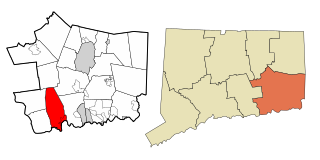
East Lyme is a town in New London County, Connecticut, United States. The town is part of the Southeastern Connecticut Planning Region. The population was 18,693 at the 2020 census. The villages of Niantic and Flanders are located in the town.

Elizabeth City County was a county in southeastern Virginia from 1634 until 1952 when it was merged into the city of Hampton. Originally created in 1634 as Elizabeth River Shire, it was one of eight shires created in the Virginia Colony by order of the King Charles I. In 1636, it was subdivided, and the portion north of the harbor of Hampton Roads became known as Elizabeth City Shire. It was renamed Elizabeth City County a short time later.

The Virginia Peninsula is a peninsula in southeast Virginia, bounded by the York River, James River, Hampton Roads and Chesapeake Bay. It is sometimes known as the Lower Peninsula to distinguish it from two other peninsulas to the north, the Middle Peninsula and the Northern Neck.

Fox Chase is a neighborhood in Northeast Philadelphia, Pennsylvania, United States, neighbouring Oxford Circle and Rhawnhurst.
In the seventeenth century, Kecoughtan was the name of the settlement now known as Hampton, Virginia, In the early twentieth century, it was also the name of a town nearby in Elizabeth City County. It was annexed into the City of Newport News in 1927.

Buckroe Beach is a neighborhood in the independent city of Hampton, Virginia. It lies just north of Fort Monroe on the Chesapeake Bay. One of the oldest recreational areas in the state, it was long located in Elizabeth City County near the downtown area of the lost town of Phoebus prior to their consolidation with Hampton in 1952.

The Back River is an estuarine inlet of the Chesapeake Bay between the independent cities of Hampton and Poquoson in the Hampton Roads area of southeastern Virginia. Formed by the confluence of the Northwest and Southwest Branches, and at just over two miles (3.2 km) long, the Back River is a breeding ground for many of the Bay's prized sport fish and the well known blue crab. The river was once part of an important fishing area that provided the local canneries with the famous Chesapeake seafood that was, and still is in demand throughout the country. Although now used primarily for recreation and as a wildlife refuge, the river remains a great place to spend an afternoon with a fishing rod or a few crab traps. Factory Point, a peninsula that protects the river from the Chesapeake Bay sits at the mouth of the river adjoining the bay.
Kecoughtan High School is a public high school located in Hampton, Virginia. The current grades offered are 9–12. Kecoughtan High School is one of four high schools located in the Hampton City Public School District. The other three are Phoebus, Bethel, and Hampton high schools.
Seaford is an unincorporated community in York County, Virginia, United States, on the Virginia Peninsula. As of the 2010 Census, the Seaford postal area had a population of 3,669.
The city of Sault Ste. Marie, Ontario, Canada contains a significant number of named residential neighbourhoods, including Bayview, Broadview Gardens, Brookfield, Buckley, Carpin Beach, Cedar Heights, East Korah, Eastside, Fort Creek, Grandview Gardens, Korah, Manitou Park, McQueen, Meadow Park, Nokomis Beach, Odena, The P Patch, Pointe aux Pins, Pointe des Chênes, Pointe Louise and Steelton.
Wythe is a neighborhood in Hampton, Virginia, along the water's edge of Hampton Roads, at the end of Virginia's Lower Peninsula. It is named after one of the signers of the United States Declaration of Independence, George Wythe. The oldest historic portion of the Wythe neighborhood became known as Olde Wythe and is on the National Register of Historic Places.

Hampton Christian Academy (HCA) is a private pre-K to grade 12 Christian school located in Hampton, Virginia, United States. The school has an elementary school campus and a high school campus.
Chestnut Hill Cove is an unincorporated community in Anne Arundel County, Maryland, United States.
Oak Grove United Methodist Church is located in Chesapeake, VA, and is known as "the mother of all Methodist congregations in Hampton Roads". It has helped found four other Methodist churches in the area: Community United Methodist, Great Bridge United Methodist, Messiah United Methodist, and Oaklette United Methodist It is located on the corner of North Battlefield and Great Bridge boulevards, and was the fourth Methodist church established in the Northampton County. The church's history dates back to the 1700s, and since then the church has established a wide variety of ministries and has been declared a historical structure. The church follows Methodism, a movement started by John Wesley in an effort to reform the Church of England from within.

Sag Harbor Hills, Azurest, and Ninevah Beach Subdivisions Historic District (SANS) is an African American beachfront community in Sag Harbor, New York. Founded following World War II, the SANS community served primarily as a summer retreat for middle-class African American families during the post-WWII and Jim Crow era. African American families were not allowed at beachfront resorts, pools or beaches, and SANS began as a place of refuge from racial strife. The historic district is bordered by Hempstead Street, Richards Drive, Hampton Street, Lincoln Street, Harding Terrace, Terry Drive and the eastern end of Haven's Beach in Sag Harbor. It was placed on the National Register of Historic Places on July 10, 2019.
References
- ↑ "What's in a name? | Rip Rap Road, Hampton".
- ↑ "Organizations | FOX HILL". Archived from the original on 2016-01-25. Retrieved 2015-11-04.
| International | |
|---|---|
| National | |