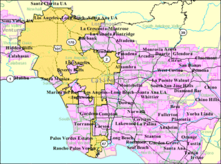
Greater Los Angeles is the second-largest metropolitan region in the United States with a population of 18.7 million as of 2020, encompassing five counties in southern California extending from Ventura County in the west to San Bernardino County and Riverside County in the east, with Los Angeles County in the center and Orange County to the southeast. According to the U.S. Census Bureau, the Los Angeles–Anaheim–Riverside combined statistical area covers 33,954 square miles (87,940 km2), making it the largest metropolitan region in the United States by land area. Of this, the contiguous urban area is 2,281 square miles (5,910 km2), the remainder mostly consisting of mountain and desert areas. In addition to being the nexus of the global entertainment industry, Greater Los Angeles is also an important center of international trade, education, media, business, tourism, technology, and sports. It is the 3rd largest metropolitan area by nominal GDP in the world with an economy exceeding $1 trillion in output.

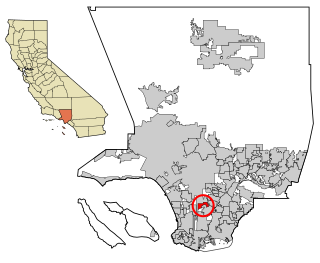
Rowland Heights is an unincorporated area in and below the Puente Hills in the San Gabriel Valley, in Los Angeles County, California, United States. The population was 48,231 at the 2020 census. Rowland Heights is in the Los Angeles metropolitan area and represented by the County of Los Angeles and is the largest census designated place in Los Angeles County by area and the county's fourth largest CDP by population. The area has a high Taiwanese population and was known as “Little Taipei” in the 1980s and 1990s, when it saw an influx of wealthy immigrants from Taiwan.
Willowbrook, alternatively named Willow Brook, is an unincorporated community and census-designated place (CDP) in Los Angeles County, California. The population was 24,295 at the 2020 census, down from 35,983 at the 2010 census.

Mission Hills is a suburban neighborhood in the City of Los Angeles, California, located in the San Fernando Valley.

Chatsworth is a suburban neighborhood in the City of Los Angeles, California, in the San Fernando Valley.

The San Gabriel Valley is one of the principal valleys of Southern California, lying generally to the east of the city of Los Angeles. Surrounding features include:

The Santa Fe Dam Recreation Area is a county park located in Irwindale, California, USA, in the San Gabriel Valley, inside the Santa Fe Dam. The park and dam are nestled among gravel quarries in the area, many of which are currently inactive. The dam is a flood-control dam on the San Gabriel River. The dam functions as a dry dam most of the time. The San Gabriels produce more gravel than most other mountains. The park is maintained and operated by the Los Angeles County Department of Parks and Recreation. The park, located off the San Gabriel River Freeway, contains a 70-acre lake for year-round fishing and non motorized watercraft.

The Sepulveda Dam is a project of the U.S. Army Corps of Engineers designed to withhold winter flood waters along the Los Angeles River. Completed in 1941, at a cost of $6,650,561, it is located south of center in the San Fernando Valley, approximately eight miles east of the river's source in the western end of the Valley, in Los Angeles, California.

The Rio Hondo is a tributary of the Los Angeles River in Los Angeles County, California, approximately 16.4 miles (26.4 km) long. As a named river, it begins in Irwindale and flows southwest to its confluence in South Gate, passing through several cities. Above Irwindale its main stem is known as Santa Anita Creek, which extends another 10 miles (16 km) northwards into the San Gabriel Mountains where the source, or headwaters, of the river are found.

Granada Hills is a suburban neighborhood in the San Fernando Valley region of the City of Los Angeles. The community has a sports program and a range of city recreation centers. The neighborhood has fourteen public and ten private schools.
West Los Angeles is an area within the city of Los Angeles, California. The residential and commercial neighborhood is divided by the Interstate 405 freeway, and each side is sometimes treated as a distinct neighborhood, mapped differently by different sources. Each lies within the larger Westside region of Los Angeles County.

Lake View Terrace is a suburban neighborhood in the San Fernando Valley region of the City of Los Angeles, California.
The Imperial Highway is a west-east thoroughfare in the counties of Los Angeles, Orange, Riverside, San Diego, and Imperial in California. The main portion of the existing route begins at Vista Del Mar in Los Angeles near the Los Angeles International Airport and ends at the Anaheim–Orange city line at Via Escola where it becomes Cannon Street. Historically, the Imperial Highway extended from Vista Del Mar to Calexico, where a portion of the highway still exists. The original route was replaced with other highways, leading the older portions of the Imperial Highway to fall out of use.

People in the San Francisco Bay Area rely on a complex multimodal transportation infrastructure consisting of roads, bridges, highways, rail, tunnels, airports, seaports, and bike and pedestrian paths. The development, maintenance, and operation of these different modes of transportation are overseen by various agencies, including the California Department of Transportation (Caltrans), the Association of Bay Area Governments, San Francisco Municipal Transportation Agency, and the Metropolitan Transportation Commission. These and other organizations collectively manage several interstate highways and state routes, two subway networks, two commuter rail agencies, eight trans-bay bridges, transbay ferry service, local bus service, three international airports, and an extensive network of roads, tunnels, and bike paths.

Cypress Park is a densely populated neighborhood of 10,000+ residents in Northeast Los Angeles, California. Surrounded by hills on three sides, it sits in the valley created by the Los Angeles River and the Arroyo Seco. It is the site of the Rio de Los Angeles State Park, the Los Angeles River Bike Path and other recreational facilities. It hosts one private and four public schools.

University Park is a 1.17 square miles (3.0 km2) neighborhood in the South Los Angeles region of Los Angeles, California. It is the home of the University of Southern California (USC), Mount St. Mary's College and Hebrew Union College. Additionally, the neighborhood is the home of the historic Shrine Auditorium.

Kenneth Hahn State Recreation Area, or Kenneth Hahn Park, is a state park unit of California in the Baldwin Hills Mountains of Los Angeles. The park is managed by the Los Angeles County Department of Parks and Recreation. As one of the largest urban parks and regional open spaces in the Greater Los Angeles Area, many have called it "L.A.'s Central Park". The 401-acre (162 ha) park was established in 1984.
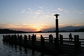
Puddingstone Reservoir is a 250-acre (1 km²) artificial lake northeast of the interchange between the Orange Freeway and the San Bernardino Freeway in Los Angeles County, California, United States. Activities include fishing, swimming, sailing, wind surfing, and camping.
The San Jose Hills are a part of the Transverse Ranges in eastern Los Angeles County, California, marking the border between the San Gabriel Valley and the Pomona Valley. It includes portions of Covina, West Covina, Walnut, Pomona, and San Dimas. To the south, the valley of San Jose Creek separates the San Jose Hills from the Puente Hills and Chino Hills.

Peter Frank Schabarum was an American football player and politician who was a member of the California State Assembly and the Los Angeles County Board of Supervisors.

