Franklin D. Roosevelt Lake

Last updated

Franklin D. Roosevelt Lake
Lake Roosevelt
Gifford Ferry.JPG
Gifford Ferry crossing Lake Roosevelt near Inchelium
USA Washington relief location map.jpg
Red pog.svg
Franklin D. Roosevelt Lake
Usa edcp relief location map.png
Red pog.svg
Franklin D. Roosevelt Lake
Location Washington, US
Coordinates 47°57′22″N118°58′50″W / 47.95611°N 118.98056°W / 47.95611; -118.98056 at Grand Coulee Dam
Lake type reservoir
Primary inflows
Primary outflows Columbia River
Basin  countriesUnited States
Surface area 125 sq mi (320 km2)
Surface elevation1,290 ft (390 m)

Franklin D. Roosevelt Lake (also called Lake Roosevelt) is the reservoir created in 1941 by the impoundment of the Columbia River by the Grand Coulee Dam in Washington state. It is named for Franklin D. Roosevelt, who was president during the construction of the dam. Covering 125 square miles (80,000 acres), it stretches about 150 miles (240 km) from the Canada–US border to Grand Coulee Dam, with over 600 miles (970 km) of shoreline; by surface area it is the largest lake and reservoir in Washington. [1] It is the home of the Lake Roosevelt National Recreation Area.

Contents

The reservoir lies in parts of five counties in northeastern Washington; roughly in descending order of lake acreage they are Ferry, Stevens, Lincoln, Okanogan, and Grant counties.

Etymology

Originally, the Bureau of Reclamation referred to the impoundment formed behind Grand Coulee Dam as the Columbia Reservoir. [2] [ better source needed ] It was unofficially referred to as "Columbia Lake" and "Empire Lake" by local newspapers, including the Colville Examiner in Stevens County; [3] [4] the latter name was chosen in a 1941 contest organized by the Spokane Daily Chronicle and forwarded to the Department of the Interior as a suggestion. [5] "Empire Lake" was suggested by 113 entries and was among the most popular of the suggestions, which also included "Grand Coulee" (later used for a separate reservoir), "Sunset", "Spokane", and "Roosevelt"; [5] entries with the name "Columbia" were not considered due to its previous rejection by federal officials as an official name. [6]

On April 17, 1945, five days after the death of President Roosevelt, Secretary of the Interior Harold L. Ickes renamed the reservoir Franklin D. Roosevelt Lake. Secretary Ickes stated this token honor recognized how President Roosevelt championed the dam and advocated the legislation to create it. [7] The accompanying Coulee Dam National Recreation Area was renamed for Roosevelt in 1996 to match the lake. [8] [9]

Administration

The lake and lands are managed under the Lake Roosevelt Cooperative Management Agreement dated April 5, 1990, succeeding an original 1946 agreement. Per the agreement, the management and regulations of Lake Roosevelt Management Area set out in the agreement are not intended to nor shall they interfere with or be inconsistent with the purposes for which the Columbia Basin Project was established, is operated and maintained; those purposes being primarily flood control, improved navigation, streamflow regulation, providing for storage and for the delivery of stored waters thereof for the reclamation of public and private lands and Indian reservations, for the generation of electrical power and for other beneficial uses, nor it is in intended to modify or alter any obligations or authority of the parties. [10]

The National Park Service manages Lake Roosevelt National Recreation Area. The NPS maintains visitor centers, boat-in campsites, shoreline camping, and conducts marine patrols for compliance with United States Coast Guard marine safety rules.

The Bureau of Reclamation has two management zones. One is directly behind the dam. It follows the log boom line from the west bank of the river to about mid-channel. Then at the Grant and Okanogan county line (in the middle of the lake) the boundary goes uplake for a short distance until it cuts across to the east shoreline. The other zone is located on the east side of the lake at China Bar, 48°49′23″N117°55′57″W / 48.82306°N 117.93250°W / 48.82306; -117.93250 . Reclamation operates a log collection facility. Reclamation captures logs and other large debris before it enters Lake Roosevelt. [11]

Bureau of Indian Affairs indirectly manages parts of the lake that are along the Colville Indian Reservation and Spokane Reservation.

Although some Washington Department of Natural Resources lands abut against Lake Roosevelt National Recreation Area, the state's Discover Pass does not cover use of NPS boat launches or tribal lands and waters.

Pollution litigation

Franklin Delano Roosevelt Lake looking downstream toward Grand Coulee Dam IMG 9097FDRlake.JPG
Franklin Delano Roosevelt Lake looking downstream toward Grand Coulee Dam

The lake is downstream from the Canadian province of British Columbia's Trail Smelter, and has been the subject of litigation over environmental concerns.

Cominco's smelter deposited slag from its plant into the Columbia River, which then flowed into Lake Roosevelt. Environmental concerns were raised when these deposits were found to include mercury, lead and zinc. This discovery led the nearby indigenous group, the Colville Confederated Tribes, to take action against Cominco and hold them responsible for degrading the water quality of the lake. The pollution raised health concerns for tribe members, who used the beaches and campsites along the river and ate fish from the river "for subsistence, cultural and spiritual reasons". [12] The lawsuit, launched in 2004, was unique in that it demanded Cominco comply with a U.S. Environmental Protection Agency (EPA) order to provide funding for pollution studies of the Trail operation. In a media statement released in 2003, Cominco agreed to invest $13-million for studies of the health and ecology of Lake Roosevelt, as well as fund the cleanup required to rid the lake of metal contamination associated with the company's smelting practices; [12] although the company's agreement to fund the studies was well-intentioned, the Colville Confederated Tribes countered that Cominco's offer was inadequate because it "did not meet the quality of studies and cleanup guarantees that would be required under EPA rules". [12]

The lawsuit between Cominco and the Colville Confederated Tribes sparked more tensions between Canada and the U.S. over transborder environmental laws. As a Canadian company, Cominco felt that their operation was being unfairly targeted because the lawsuit was ordering them to follow an American governing body's orders to clean up Lake Roosevelt. Cominco also objected to the implication in the lawsuit that it was the only company responsible for the pollution of Lake Roosevelt. [12]

In 1994, Cominco stopped depositing smelting byproducts into the Columbia River and in 2004 reportedly spent about $1 billion modernizing the Trail plant and reducing its emissions. [13]

See also

Related Research Articles

<span class="mw-page-title-main">Grant County, Washington</span> County in Washington, United States

Grant County is a county located in the U.S. state of Washington. As of the 2020 census, the population was 99,123. The county seat is Ephrata, and the largest city is Moses Lake. The county was formed out of Douglas County in February 1909 and is named for U.S. President Ulysses S. Grant.

<span class="mw-page-title-main">Grand Coulee Dam</span> Dam in Grant and Okanogan counties, near Coulee Dam and Grand Coulee, Washington, US

<span class="mw-page-title-main">Columbia Basin Project</span> American irrigation project

The Columbia Basin Project in Central Washington, United States, is the irrigation network that the Grand Coulee Dam makes possible. It is the largest water reclamation project in the United States, supplying irrigation water to over 670,000 acres (2,700 km2) of the 1,100,000 acres (4,500 km2) large project area, all of which was originally intended to be supplied and is still classified irrigable and open for the possible enlargement of the system. Water pumped from the Columbia River is carried over 331 miles (533 km) of main canals, stored in a number of reservoirs, then fed into 1,339 miles (2,155 km) of lateral irrigation canals, and out into 3,500 miles (5,600 km) of drains and wasteways. The Grand Coulee Dam, powerplant, and various other parts of the CBP are operated by the Bureau of Reclamation. There are three irrigation districts in the project area, which operate additional local facilities.

<span class="mw-page-title-main">Colville Indian Reservation</span> Indian reservation in Washington, United States

The Colville Indian Reservation is an Indian reservation in the northwest United States, in north central Washington, inhabited and managed by the Confederated Tribes of the Colville Reservation, which is federally recognized.

<span class="mw-page-title-main">Kettle Falls</span> Historical waterfall on the Columbia River in Washington (state), United States

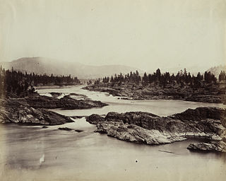
Kettle Falls was an ancient and important salmon fishing site on the upper reaches of the Columbia River, in what is today the U.S. state of Washington, near the Canada–US border. The falls consisted of a series of rapids and cascades where the river passed through quartzite rocks deposited by prehistoric floods on a substrate of Columbia River basalt. The river dropped nearly 50 feet (15 m), and the sound of the falls could be heard for miles away. Kettle Falls was inundated in 1940, as the waters of the reservoir Lake Roosevelt rose behind Grand Coulee Dam, permanently flooding the site.

<span class="mw-page-title-main">Teck Resources</span> Natural resources company

Teck Resources Limited, known as Teck Cominco until late 2008, is a diversified natural resources company headquartered in Vancouver, British Columbia, that is engaged in mining and mineral development, including coal for the steelmaking industry, copper, zinc, and energy. Secondary products include lead, silver, gold, molybdenum, germanium, indium and cadmium. Teck Resources was formed from the amalgamation of Teck and Cominco in 2001.

<span class="mw-page-title-main">Lake Roosevelt National Recreation Area</span>

Lake Roosevelt National Recreation Area is a U.S. national recreation area that encompasses the 130-mile (210 km) long Franklin D. Roosevelt Lake between Grand Coulee Dam and Northport, Washington, in eastern Washington state. The Grand Coulee Dam was built on the Columbia River in 1941 as part of the Columbia River Basin project. Lake Roosevelt National Recreation Area is a unit of the National Park Service and provides opportunities for fishing, swimming, canoeing, boating, hunting, camping, and visiting historic Fort Spokane and St. Paul's Mission. Crescent Bay Lake in Grant County just southwest of Lake Roosevelt also falls under the jurisdiction of the National Recreation Area.

<span class="mw-page-title-main">American Falls Dam</span> Dam in Idaho, U.S.

The American Falls Dam is a concrete gravity-type dam in the western United States, located near American Falls, Idaho, on river mile 714.7 of the Snake River. The dam and reservoir are a part of the Minidoka Project on the Snake River Plain and are used primarily for flood control, irrigation, and recreation. When the original dam was built in the 1920s by the U.S. Bureau of Reclamation, the residents of American Falls were forced to relocate three-quarters of their town to make room for the reservoir.

<span class="mw-page-title-main">Washington State Route 25</span> Highway in Washington

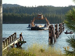
State Route 25 (SR 25), named the Coulee Reservoir Highway, is a 121.17-mile-long (195.00 km) state highway serving communities in Lincoln and Stevens counties in the U.S. state of Washington. The highway begins at an intersection with U.S. Route 2 (US 2) east of Davenport and continues northwest to cross the Spokane River. From there, SR 25 parallels the Columbia River and Franklin D. Roosevelt Lake upstream through several small communities, passing the Gifford–Inchelium Ferry, to Kettle Falls. In Kettle Falls, the roadway intersects US 395, co-signed with SR 20 and continues north to Northport, where former SR 251 is intersected and SR 25 crosses the Columbia River on the Northport Bridge. The highway travels northwest to the Canadian border, where it becomes British Columbia Highway 22 (BC 22).

<span class="mw-page-title-main">Deer Flat National Wildlife Refuge</span> Breeding area for mammals, birds, and other animals

The Deer Flat National Wildlife Refuge is an important breeding area for mammals, birds, and other animals. The National Wildlife Refuge is located on land surrounding Lake Lowell, just outside Nampa, Idaho. It serves as a resting and wintering area for birds, including mallards and Canada geese, along the Pacific Flyway and was named a "Globally Important Bird Area" by the American Bird Conservancy.

<span class="mw-page-title-main">Drumheller Channels National Natural Landmark</span> U.S. natural landmark in Washington state

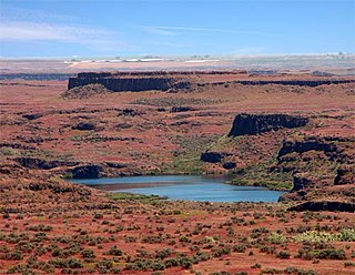
Drumheller Channels National Natural Landmark showcases the Drumheller Channels, which are the most significant example in the Columbia Plateau of basalt butte-and-basin Channeled Scablands. This National Natural Landmark is an extensively eroded landscape, located in south central Washington state characterized by hundreds of isolated, steep-sided hills (buttes) surrounded by a braided network of numerous channels, all but one of which are currently dry. It is a classic example of the tremendous erosive powers of extremely large floods such as those that reformed the Columbia Plateau volcanic terrain during the late Pleistocene glacial Missoula Floods.

<span class="mw-page-title-main">Crab Creek</span> River in Washington, United States

Crab Creek is a stream in the U.S. state of Washington. Named for the presence of crayfish, it is one of the few perennial streams in the Columbia Basin of central Washington, flowing from the northeastern Columbia River Plateau, roughly 5 km (3.1 mi) east of Reardan, west-southwest to empty into the Columbia River near the small town of Beverly. Its course exhibits many examples of the erosive powers of extremely large glacial Missoula Floods of the late Pleistocene, which scoured the region. In addition, Crab Creek and its region have been transformed by the large-scale irrigation of the Bureau of Reclamation's Columbia Basin Project (CBP), which has raised water table levels, significantly extending the length of Crab Creek and created new lakes and streams.

<span class="mw-page-title-main">Banks Lake</span> Reservoir in Washington, United States

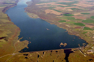
Banks Lake is a 27-mile (43 km) long reservoir in central Washington in the United States.

<span class="mw-page-title-main">Jackson Lake Dam</span> Dam in Wyoming, in Grand Teton National Park

Jackson Lake Dam is a concrete and earth-fill dam in the western United States, at the outlet of Jackson Lake in northwestern Wyoming. The lake and dam are situated within Grand Teton National Park in Teton County. The Snake River emerges from the dam and flows about eight hundred miles (1,300 km) through Wyoming, Idaho, Oregon, and Washington to its mouth on the Columbia River in eastern Washington.

<span class="mw-page-title-main">Sanpoil River</span> River in Okanagan Highlands, United States

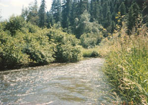
The Sanpoil River is a tributary of the Columbia River, in the U.S. state of Washington. The river is named for the Sanpoil, the Interior Salish people who live along the river course. The name is from the Okanagan term [snpʕʷílx], meaning "people of the gray country", or "gray as far as one can see".

<span class="mw-page-title-main">Dry Falls Dam</span> Dam in Washington, USA

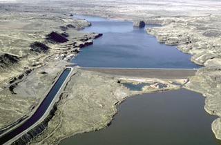
Dry Falls Dam is a rockfaced earthfill type dam in the U.S. state of Washington. Located in Grant County near Coulee City, it was built as part of the Bureau of Reclamation's Columbia Basin Project. Water from the Columbia River, impounded by Grand Coulee Dam, is pumped into Grand Coulee, a formerly dry canyon, through the short Feeder Canal. Grand Coulee's north end is sealed by North Dam and Dry Falls Dam stretches across the midsection of the Coulee. This allows the water pumped from the Columbia River to fill the upper Grand Coulee, creating a large equalizing reservoir known as Banks Lake. Water from the reservoir is fed into the irrigation project's Main Canal, which runs south from Dry Falls Dam to another reservoir called Billy Clapp Lake, formed by Pinto Dam.

<span class="mw-page-title-main">Trail Smelter dispute</span>

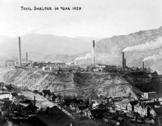
The Trail Smelter dispute was a trans-boundary pollution case involving the federal governments of both Canada and the United States, which eventually contributed to establishing the harm principle in the environmental law of transboundary pollution.

<span class="mw-page-title-main">Pinto Dam</span> Dam in Washington, USA

Pinto Dam is a dam in Grant County, Washington.

<span class="mw-page-title-main">Outline of Washington (state) infrastructure</span> Overview of and topical guide to infrastructure of the U.S. state of Washington

The following outline is provided as an overview of and topical guide to infrastructure of the U.S. state of Washington.

Pakootas v. Teck Cominco Metals is a citizen lawsuit filed under the 1980 Comprehensive Environmental Response, Compensation, and Liability Act (CERCLA) by Joseph A. Pakootas and Donald R. Michel brought to the United States District Court for the Eastern District of Washington against Teck Cominco—, now Teck Resources—which is headquartered in Canada. Pakootas and Michel filed the suit The plaintiffs, Pakootas and Michel, were enrolled members of the Confederated Tribes of the Colville Reservation who, under CERCLA's citizen suit provision filed the suit to enforce the "Unilateral Administrative Order for Remedial Investigation/Feasibility Study (UAO) issued to the defendant by the United States Environmental Protection Agency (EPA).

References

  1. "The Story of the Columbia Basin Project". National Park Service. United States Printing Office. 1964. Retrieved December 13, 2020.
  2. email from National Archives Denver office March 25, 2015
  3. "Courthouse and County News". Colville Examiner . April 28, 1945. p. 4. Retrieved November 26, 2022 via Newspapers.com.
  4. "Big Empire Lake Now a Reality". Colville Examiner. August 2, 1941. p. 1. Retrieved November 26, 2022 via Newspapers.com.
  5. 1 2 "Contest Judges Choose "Empire Lake" as Best". Spokane Daily Chronicle . March 19, 1941. p. 1. Retrieved November 26, 2022 via Newspapers.com.
  6. "Chronicle Seeks Name for Lake". Spokane Daily Chronicle. February 19, 1941. p. 1. Retrieved November 26, 2022 via Newspapers.com.
  7. "Lake Formed by Coulee Dam Will Bear Roosevelt's Name". Spokane Daily Chronicle. Associated Press. April 17, 1945. p. 9. Retrieved November 26, 2022 via Newspapers.com.
  8. "Dam's recreation area will keep its old name". The Spokesman-Review. Associated Press. October 2, 1996. p. B3. Retrieved March 5, 2023 via Newspapers.com.
  9. Streiffert, Kristi G. (December 8, 1996). "Recreation area gets new name, marks 50th anniversary". The Spokesman-Review. p. G3. Retrieved March 5, 2023 via Newspapers.com.
  10. "National Park Service Administrative History". Lake Roosevelt NRA. National Park Service. Retrieved April 15, 2015.
  11. Lynne, Brougher. "Public Affairs". Grand Coulee Dam, Bureau of Reclamation. Bureau of Reclamation. Archived from the original on April 23, 2015. Retrieved April 15, 2015.
  12. 1 2 3 4 Geranios, Nicholas (July 22, 2004). "Colvilles sue Teck Cominco over pollution". Associated Press Newswires.
  13. Stueck, 2004

Further reading