
Bellevue is a city in the Eastside region of King County, Washington, United States, located across Lake Washington from Seattle. It is the third-largest city in the Seattle metropolitan area and has variously been characterized as a satellite city, a suburb, a boomburb, or an edge city. Its population was 122,363 at the 2010 census and 151,854 in the 2020 census. The city's name is derived from the French term belle vue.

Mercer Island is a city in King County, Washington, United States, located on an island of the same name in the southern portion of Lake Washington. Mercer Island is in the Seattle metropolitan area, with Seattle to its west and Bellevue to its east.
State Route 520 (SR 520) is a state highway and freeway in the Seattle metropolitan area, part of the U.S. state of Washington. It runs 13 miles (21 km) from Seattle in the west to Redmond in the east. The freeway connects Seattle to the Eastside region of King County via the Evergreen Point Floating Bridge on Lake Washington. SR 520 intersects several state highways, including Interstate 5 (I-5) in Seattle, I-405 in Bellevue, and SR 202 in Redmond.
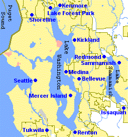
The Eastside of the King County, Washington area in the United States is a collective term for the suburbs of Seattle located on the east side of Lake Washington.

The Third Lake Washington Bridge, officially the Homer M. Hadley Memorial Bridge, is a floating bridge in the Seattle metropolitan area of the U.S. state of Washington. It is one of the Interstate 90 floating bridges, carrying the westbound lanes of Interstate 90 across Lake Washington between Mercer Island and Seattle. The floating bridge is the fifth-longest of its kind in the world, at 5,811 feet.

Transportation in Seattle is largely focused on the automobile like many other cities in western North America; however, the city is just old enough for its layout to reflect the age when railways and trolleys predominated. These older modes of transportation were made for a relatively well-defined downtown area and strong neighborhoods at the end of several former streetcar lines, now mostly bus lines.

Interstate 405 (I-405) is a north–south auxiliary Interstate Highway serving the Seattle region of Washington, United States. It bypasses Seattle east of Lake Washington, traveling through the Eastside area of King and Snohomish counties, providing an alternate route to I-5. The 30-mile (48 km) freeway serves the cities of Renton, Bellevue, Kirkland, and Bothell. I-405 terminates at I-5 in Tukwila and Lynnwood, and also intersects several major highways, including SR 167, I-90, SR 520, and SR 522.
Bellevue High School is a public secondary school located in Bellevue, Washington. Bellevue has 1632 students enrolled in grades 9 through 12.

The East Channel Bridge is a bridge carrying Interstate 90 from Mercer Island, Washington, to Bellevue, Washington, over the East Channel of Lake Washington, which separates Mercer Island from the rest of the Eastside.
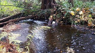
Kelsey Creek is a creek in Bellevue, Washington on Seattle's Eastside. Originating in the wetlands in the Lake Hills greenbelt between Phantom Lake and Larsen Lake, it flows north and west through the Crossroads neighborhood and then south to Kelsey Creek Park where it turns west and becomes the Mercer Slough just west of Interstate 405. The centerpiece of the largest wetland adjacent to Lake Washington at 367 acres (149 ha), the slough empties into the East Channel of Lake Washington at Interstate 90.

The Mount Baker Tunnel or Mount Baker Ridge Tunnel carries Interstate 90 under the Mount Baker neighborhood of Seattle, Washington. It is actually a group of three tunnels that carry eight lanes of freeway traffic, plus a separate path for bicycles and pedestrians. The two originals are twin tunnel bores completed in 1940 and rehabilitated in 1993. The newest tunnel was built north of the original tunnels and opened in June 1989. The tunnel has a double-decked roadway with the bicycle/pedestrian path above the traffic lanes.

Interstate 90 (I-90), designated as the American Veterans Memorial Highway, is a transcontinental Interstate Highway that runs from Seattle, Washington, to Boston, Massachusetts. It crosses Washington state from west to east, traveling 298 miles (480 km) from Seattle across the Cascade Mountains and into Eastern Washington, reaching the Idaho state line east of Spokane. I-90 intersects several of the state's other major highways, including I-5 in Seattle, I-82 and U.S. Route 97 (US 97) near Ellensburg, and US 395 and US 2 in Spokane.

The East Link Extension, also known as Line 2, is a future light rail line serving the Eastside region of the Seattle metropolitan area in the U.S. state of Washington. It will be part of Sound Transit's Link light rail system, running 14 miles (23 km) from west to east and serving 10 stations in Downtown Seattle, Mercer Island, Bellevue, and Redmond. Line 2 is scheduled to open in 2024 and will continue into the Downtown Seattle Transit Tunnel and share stations with Line 1. A 3.7-mile-long (6.0 km) extension to Downtown Redmond with two additional stations is scheduled to open in 2025.

Bellevue Transit Center (BTC) is a bus station and future light rail station in Bellevue, Washington, a suburb of Seattle. It is the main transit hub for the Eastside of King County, serving 20 routes from King County Metro and Sound Transit Express. The transit center is the western terminus of the RapidRide B Line, which runs east to Redmond.

Wilburton station is a future Link light rail station in Bellevue, Washington, on Sound Transit's East Link Extension. The elevated station, expected to open in 2024, will serve the area immediately east of Downtown Bellevue, including Lake Bellevue and the Overlake Hospital Medical Center.

The Microsoft campus is the corporate headquarters of Microsoft, located in Redmond, Washington, United States, a part of the Seattle metropolitan area. Microsoft initially moved onto the grounds of the campus on February 26, 1986, shortly before going public on March 13. The headquarters has undergone multiple expansions since its establishment and is presently estimated to encompass over 8 million square feet (740,000 m2) of office space and have over 50,000 employees.

Frederick Kemper Freeman Jr. is the active chairman and CEO of Kemper Development Company, which built and operates Bellevue Square, Bellevue Place, and Lincoln Square, all located in Bellevue, Washington. Kemper represents the third generation of the Freeman family, who have been involved in the growth of the Bellevue community since 1897. He is a former Republican member of the Washington State House of Representatives from the 48th district and publicly active in conversations about traffic and transportation in Bellevue.

The Eastside Rail Corridor, officially Eastrail, is a rail Right of way where a rail trail is under development in the Eastside suburbs of Seattle, Washington. The corridor follows the path of the former Woodinville Subdivision from Renton to the City of Snohomish at Snohomish Junction. The northern portion was still in operation in 2017 by Eastside Freight Railroad.

The Bellevue City Hall is a government office building and city hall in Bellevue, Washington. The current city hall, located in Downtown Bellevue, opened in 2006 after the $121 million renovation of a former Qwest data center. The data center, originally built for Pacific Northwest Bell in 1983, was acquired by the city government in 2002 for use by the Bellevue Police Department and later approved as the new city hall. It incorporates use of wood interiors and a terra cotta exterior that has been recognized with several design awards since its opening.

Bellevue 600 is a future high-rise office building developed by Amazon in Bellevue, Washington, United States. It began construction in 2021 and is scheduled to be completed in 2024. The 43-story, 600-foot-tall (180 m) building would join 555 Tower as the tallest building in Bellevue. The project is located in Downtown Bellevue at the intersection of Northeast 6th Street and 110th Avenue Northeast, adjacent to the Bellevue Transit Center and a future Link light rail station. A second phase would construct a 27-story tower to the west, replacing an existing office building.


