
Interstate 89 (I-89) is an Interstate Highway in the New England region of the United States traveling from Bow, New Hampshire, to the Canada–United States border between Highgate Springs, Vermont, and Saint-Armand, Quebec. As with all odd-numbered primary Interstates, I-89 is signed as a north–south highway. However, it follows a primarily northwest-to-southeast path. The route forms a major part of the main connection between the cities of Montreal and Boston. In Quebec, the route continues as Route 133. The eventual completion of Autoroute 35 will lead to a nonstop limited-access highway route between Boston and Montreal, following I-93 south from I-89's terminus. The largest cities directly served by I-89 are Concord, the state capital of New Hampshire; Montpelier, the state capital of Vermont; and Burlington, Vermont. I-89 is one of three main Interstate highways whose route is located entirely within New England, along with I-91 and I-93.
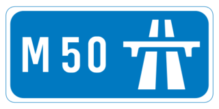
The M50 motorway is a C-shaped orbital motorway in Dublin and the busiest motorway in Ireland. The current route was built in various sections over the course of 27 years, from 1983 to 2010. It begins at Dublin Port, running northward through the Dublin Port Tunnel and along a portion of the Airport Motorway. It then turns west at its junction with the M1, circling the northern, western and southern suburbs of Dublin, before merging with the M11 at Shankill in South East Dublin. The road forms part of European route E01.

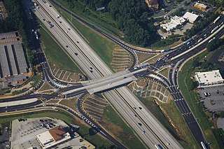
A cloverleaf interchange is a two-level interchange in which all turns are handled by slip roads. To go left, vehicles first continue as one road passes over or under the other, then exit right onto a one-way three-fourths loop ramp (270°) and merge onto the intersecting road. The objective of a cloverleaf is to allow two highways to cross without the need for any traffic to be stopped by traffic lights. The limiting factor in the capacity of a cloverleaf interchange is traffic weaving.

In civil engineering, grade separation is a method of aligning a junction of two or more surface transport axes at different heights (grades) so that they will not disrupt the traffic flow on other transit routes when they cross each other. The composition of such transport axes does not have to be uniform; it can consist of a mixture of roads, footpaths, railways, canals, or airport runways. Bridges, tunnels, or a combination of both can be built at a junction to achieve the needed grade separation.

A diamond interchange is a common type of road junction, used where a controlled-access highway crosses a minor road.
The Hampton Roads Beltway is a loop of Interstate 64 and Interstate 664, which links the communities of the Virginia Peninsula and South Hampton Roads which surround the body of water known as Hampton Roads and comprise much of the region of the same name in the southeastern portion of Virginia in the United States. It crosses the harbor of Hampton Roads at two locations on large four-laned bridge-tunnel facilities: the eastern half carries Interstate 64 and uses the Hampton Roads Bridge-Tunnel and the western half carries Interstate 664 and uses the Monitor-Merrimac Memorial Bridge-Tunnel. The beltway has the clockwise direction signed as the Inner Loop, and the counter-clockwise direction signed as the Outer Loop. The entire beltway, including the bridge-tunnels, is owned and operated by the Virginia Department of Transportation.
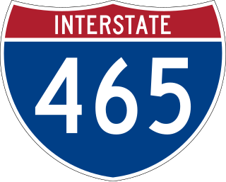
Interstate 465 (I-465), also known as the USS Indianapolis Memorial Highway, is the beltway circling Indianapolis, Indiana. It is roughly rectangular in shape and has a perimeter of approximately 53 miles (85 km). It lies almost completely within the boundaries of Marion County, except for two short sections on the north leg in Boone and Hamilton counties. It intersects with I-65, I-69, I-70, and I-74 and provides additional access to I-65 via I-865.

A partial cloverleaf interchange or parclo is a modification of a cloverleaf interchange.

Interstate 675 (I-675) is an auxiliary Interstate Highway in the suburbs of Dayton in the US state of Ohio. I-675 serves as an eastern bypass of Dayton that is 26.53 miles (42.70 km) long. As originally proposed, the route was to reconnect with I-75 north of Dayton near Northridge rather than going east toward Springfield and I-70. Construction was completed in 1987, though some have lobbied to extend the highway west of Dayton.
A diverging diamond interchange (DDI), also called a double crossover diamond interchange (DCD), is a subset of diamond interchange in which the opposing directions of travel on the non-freeway road cross each other on either side of the interchange so that traffic crossing the freeway on the overpass or underpass is operating on the opposite driving side from that which is customary for the jurisdiction. The crossovers may employ one-side overpasses or be at-grade and controlled by traffic lights.

In the field of road transport, an interchange or a grade-separated junction is a road junction that uses grade separations to allow for the movement of traffic between two or more roadways or highways, using a system of interconnecting roadways to permit traffic on at least one of the routes to pass through the junction without interruption from crossing traffic streams. It differs from a standard intersection, where roads cross at grade. Interchanges are almost always used when at least one road is a controlled-access highway or a limited-access divided highway (expressway), though they are sometimes used at junctions between surface streets.
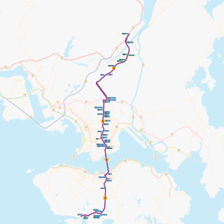
Route 1 is a major artery in Hong Kong that runs in a generally north-south direction, connecting Aberdeen with Sha Tin.

Alberta Provincial Highway No. 216, better known by its official name of Anthony Henday Drive, is a 78-kilometre (48 mi) freeway that encircles Edmonton, Alberta. It is a heavily travelled commuter and truck bypass route with the southwest quadrant serving as a portion of the CANAMEX Corridor that links Canada to the United States and Mexico. Henday is one of the busiest highways in Western Canada, carrying over 95,000 vehicles per day in 2022 at its busiest point near West Edmonton Mall. Rush hour congestion is common on the four-lane section in southwest Edmonton, where traffic levels have risen due to rapid suburban development. Work began in fall 2019 to widen this section to six lanes by the end of 2023.

A junction is where two or more roads meet.

Interstate 70 (I-70) is an Interstate Highway that is located in the Commonwealth of Pennsylvania in the United States. It runs east to west across the southwest part of Pennsylvania and serves the southern fringe of the Pittsburgh metropolitan area.

U.S. Route 15 (US 15) is a part of the United States Numbered Highway System that runs from Walterboro, South Carolina, to Painted Post, New York. In Virginia, the U.S. Highway runs 230.37 miles (370.74 km) from the North Carolina state line near Clarksville north to the Maryland state line at the Potomac River near Lucketts. US 15 is a major north–south highway through the Piedmont of Virginia, connecting Clarksville and Farmville in Southside with Culpeper, Warrenton, and Leesburg in Northern Virginia.
The Lexington Area Metropolitan Planning Organization (MPO) has been involved with transportation planning in Lexington, Kentucky, USA, and its immediate area since being established in 1974. It is responsible, in cooperation with the Kentucky Transportation Cabinet, for planning and coordinating all aspects of transportation planning on behalf of local governments within its region, which includes the Lexington-Fayette Urban County Government and Jessamine County.

U.S. Route 322 is a spur of US 22, running from Cleveland, Ohio, east to Atlantic City, New Jersey. In the U.S. state of Pennsylvania, the route runs from the Ohio state line in West Shenango Township southeast to the Commodore Barry Bridge over the Delaware River in Chester, at which point the route crosses into New Jersey, meeting the New Jersey Turnpike at exit 2. The route passes near or through several cities, including Meadville, DuBois, State College, and Harrisburg. US 322 in Pennsylvania is named the 28th Division Highway in honor of the 28th Infantry Division.
James River Freeway is a 14-mile-long (23 km) freeway located largely on the south side of Springfield, Missouri. Its western terminus is at Interstate 44 (I-44) north of Brookline and its eastern terminus is at U.S. Route 65 (US 65) in southeastern Springfield. It is named for the James River, which passes near the highway at the freeway's eastern terminus. A total of four highways are routed on the highway: Route 360, US 60, US 160, Route 13, and Business US 65.

Terminology related to road transport—the transport of passengers or goods on paved routes between places—is diverse, with variation between dialects of English. There may also be regional differences within a single country, and some terms differ based on the side of the road traffic drives on. This glossary is an alphabetical listing of road transport terms.