The Missouri River is the longest river in North America. Rising in the Rocky Mountains of western Montana, the Missouri flows east and south for 2,341 miles (3,767 km) before entering the Mississippi River north of St. Louis, Missouri. The river takes drainage from a sparsely populated, semi-arid watershed of more than half a million square miles (1,300,000 km2), which includes parts of ten U.S. states and two Canadian provinces. When combined with the lower Mississippi River, it forms the world's fourth longest river system.

The South Platte River is one of the two principal tributaries of the Platte River. Flowing through the U.S. states of Colorado and Nebraska, it is itself a major river of the American Midwest and the American Southwest/Mountain West. Its drainage basin includes much of the eastern flank of the Rocky Mountains in Colorado; much of the populated region known as the Colorado Front Range and Eastern Plains; and a portion of southeastern Wyoming in the vicinity of the city of Cheyenne. It joins the North Platte River in western Nebraska to form the Platte, which then flows across Nebraska to the Missouri. The river serves as the principal source of water for eastern Colorado. In its valley along the foothills in Colorado, it has permitted agriculture in an area of the Colorado Piedmont and Great Plains that is otherwise arid.

The Colorado River is an 862-mile (1,387 km) long river in the U.S. state of Texas. It is the 18th longest river in the United States and the longest river with both its source and its mouth within Texas.

The North Platte River is a major tributary of the Platte River and is approximately 716 miles (1,152 km) long, counting its many curves. In a straight line, it travels about 550 miles (890 km), along its course through the U.S. states of Colorado, Wyoming, and Nebraska.

The Musselshell River is a tributary of the Missouri River, 341.9 miles (550.2 km) long from its origins at the confluence of its North and South Forks near Martinsdale, Montana to its mouth on the Missouri River. It is located east of the Continental divide entirely within Montana in the United States. Counting its pre-confluence tributaries, it measures 425–500 miles (684–805 km) in length.

The Cheyenne River, also written Chyone, referring to the Cheyenne people who once lived there, is a tributary of the Missouri River in the U.S. states of Wyoming and South Dakota. It is approximately 295 miles (475 km) long and drains an area of 24,240 square miles (62,800 km2). About 60% of the drainage basin is in South Dakota and almost all of the remainder is in Wyoming.

The Niobrara River is a tributary of the Missouri River, approximately 568 miles (914 km) long, running through the U.S. states of Wyoming and Nebraska. The river drains one of the most arid sections of the Great Plains, and has a low flow for a river of its length. The Niobrara's watershed includes the northern tier of Nebraska Sandhills, a small south-central section of South Dakota, as well as a small area of eastern Wyoming.
Nebraska Public Power District (NPPD) is the largest electric utility in the state of Nebraska, serving all or parts of 91 counties. It was formed on January 1, 1970, when Consumers Public Power District, Platte Valley Public Power and Irrigation District (PVPPID) and Nebraska Public Power System merged to become Nebraska Public Power District. NPPD's predecessors were created through the efforts of the Nebraska legislature and financial agent Guy L. Myers as part of a system where all the investor-owned utilities operating in the state of Nebraska were condemned and their properties turned over to 'public power districts' being created at the time. NPPD is a public corporation and political subdivision of the state of Nebraska. The utility is governed by an 11-member Board of Directors, who are popularly elected from NPPD's chartered territory.

Lodgepole Creek is a tributary of the South Platte River, approximately 278 miles (447 km) long, in the U.S. states of Wyoming, Nebraska and Colorado. Lodgepole Creek drains a basin in the interior of a low plateau which lies between the South Platte Basin and the North Platte Basin in the southeastern corner of Wyoming, the southern edge of the Nebraska Panhandle and several small portions of northeastern Colorado. As its name implies, Lodgepole Creek is a very small stream; for nearly all of its length it flows through the semiarid High Plains. The Lodgepole Creek Valley has been a major transportation route for over 100 years; the line of the original transcontinental railroad, the Lincoln Highway/U.S. Highway 30 and Interstate 80 all run along the stream for much of its length.

Lewis and Clark Lake is a 31,400 acre (130 km²) reservoir located on the border of the U.S. States of Nebraska and South Dakota on the Missouri River. The lake is approximately 25 miles (40 km) in length with over 90 miles (140 km) of shoreline and a maximum water depth of 45 feet (14 m). The lake is impounded by Gavins Point Dam and is managed by the U.S. Army Corps of Engineers, Omaha District.

Crab Creek is a stream in the U.S. state of Washington. Named for the presence of crayfish, it is one of the few perennial streams in the Columbia Basin of central Washington, flowing from the northeastern Columbia River Plateau, roughly 5 km (3.1 mi) east of Reardan, west-southwest to empty into the Columbia River near the small town of Beverly. Its course exhibits many examples of the erosive powers of extremely large glacial Missoula Floods of the late Pleistocene, which scoured the region. In addition, Crab Creek and its region have been transformed by the large-scale irrigation of the Bureau of Reclamation's Columbia Basin Project (CBP), which has raised water table levels, significantly extending the length of Crab Creek and created new lakes and streams.

Lake McConaughy is a reservoir on the North Platte River. It is located 9 miles (14 km) north of Ogallala, Nebraska, United States, near U.S. Highway 26 and Nebraska Highway 61. The reservoir was named for Charles W. McConaughy, a grain merchant and mayor of Holdrege, Nebraska, one of the leading promoters of the project. Although he did not live to see the completion of the project, his leadership and perseverance eventually culminated in a public power and irrigation project that helped Nebraska become one of the nation's leading agricultural states.

Enders is an unincorporated community and census-designated place in Chase County, Nebraska, United States. As of the 2010 census it had a population of 42. Although Enders is unincorporated, it has a post office, with the ZIP code of 69027.
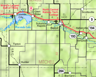
Waconda Lake, also known as Glen Elder Reservoir, is a reservoir in Mitchell County and Osborne County, Kansas, United States. Built and managed by the U.S. Bureau of Reclamation for flood control and irrigation, it is also used for recreation. Glen Elder State Park is located on its north shore.

The Colorado River is a major river of the western United States and northwest Mexico in North America. Its headwaters are in the Rocky Mountains where La Poudre Pass Lake is its source. Located in north central Colorado it flows southwest through the Colorado Plateau country of western Colorado, southeastern Utah and northwestern Arizona where it flows through the Grand Canyon. It turns south near Las Vegas, Nevada, forming the Arizona–Nevada border in Lake Mead and the Arizona–California border a few miles below Davis Dam between Laughlin, Nevada and Needles, California California before entering Mexico in the Colorado Desert. Most of its waters are diverted into the Imperial Valley of Southern California. In Mexico its course forms the boundary between Sonora and Baja California before entering the Gulf of California. This article describes most of the major features along the river.

Lovewell Reservoir is a reservoir in Jewell County, Kansas, United States. Built and managed by the U.S. Bureau of Reclamation, it is used for flood control, irrigation, and recreation. Lovewell State Park is located on its north shore.

Champion Mill is a historic flour and feed mill in Champion, in the southwestern part of the state of Nebraska, in the Midwestern United States. Built in 1888 and rebuilt in 1892 after a fire, the mill was used commercially until 1968. It is now a museum and park run by Chase County preserving the state's last working water-powered mill. The mill, headrace, and dam were added to the National Register of Historic Places as a historic district in 1988.
The Salt Creek Dams, {officially The Salt Creek and Tributaries Flood Control Project) are a U.S. Army Corps of Engineers water resource development project located in southeastern Nebraska near Lincoln, Nebraska, the state capitol. The project was authorized by the Federal Flood Control Act of 1958 to provide flood damage reduction, water quality, recreation, and fish and wildlife enhancement. The basin drains a 1645 square mile area of southeastern Nebraska, encompassing the City of Lincoln. Salt Creek enters the Platte River from the right bank 25 miles southwest of Omaha, Nebraska and drains the southern and western part of the basin, while Wahoo Creek drains the northeastern portion. The lakes are a part of the Missouri River basin.