Division No. 1, Subdivision A is an unorganized subdivision on the Avalon Peninsula in Newfoundland and Labrador, Canada. It is in Division No. 1, and lies between Trinity Bay and Placentia Bay.

The Avalon Peninsula is a large peninsula that makes up the southeast portion of the island of Newfoundland. It is 9,220.61 square kilometres (3,560.10 sq mi) in size.

Avalon is a federal electoral district on Newfoundland Island in Newfoundland and Labrador, Canada. It has been represented in the House of Commons of Canada since 2004.
Placentia Bay is a body of water on the southeast coast of Newfoundland, Canada. It is formed by Burin Peninsula on the west and Avalon Peninsula on the east. Fishing grounds in the bay were used by native people long before the first European fishermen arrived in the 16th century. For a time, the French controlled the bay. They built their capital at Placentia on the east coast. The British gained Placentia during the Treaty of Utrecht in 1713. The town and nearby Castle Hill are national historic sites. English settlement followed in the bay and today the main communities are Burin, Marystown, and Placentia.

Placentia is a town located in the Canadian province of Newfoundland and Labrador. It consists of the Argentia Industrial Park and amalgamated communities of Townside, Freshwater, Dunville, Southeast, Point Verde and Jerseyside.
The Burin Peninsula is a peninsula located on the south coast of the island of Newfoundland in the province of Newfoundland and Labrador. Marystown is the largest population centre on the peninsula.
Villa Marie was a settlement in Newfoundland, Canada. It began as a quarry for Silica that operated from 1968 to 1988. It was located northeast of Placentia, along the C.N.R. tracks. It is now part of the Town of Placentia.
Colinet is an incorporated town located on the northwest arm of St. Mary's Bay in Newfoundland and Labrador, Canada.

Argentia is a Canadian commercial seaport and industrial park located in the Town of Placentia, Newfoundland and Labrador. It is situated on the southwest coast of the Avalon Peninsula and defined by a triangular shaped headland which reaches northward out into Placentia Bay creating a natural harbour 3 km (1.9 mi) in length.
Dunville is a neighborhood located in the Town of Placentia, in Canada. it was earlier called Northeast or North East Placentia. The name was formed from "Dunphy's Village" a part of Northeast Placentia. It is a community that makes up the north-eastern section of the Town of Placentia. It stretches approximately 8 km along the northern shore of the North-East Arm of Placentia Bay.
Oderin Island is an island in the province of Newfoundland and Labrador in western Placentia Bay, located about 30 km northeast of Marystown. Oderin was originally settled by the French who considered it an important fishing post and had fortified it against the English. The name was originally Audierne, named after a town in France. In 1712, the French authorities in Placentia ordered all the buildings and fishing premises to be burned or destroyed, in part to deny to English the use of the site but also as retribution against the local French merchant Lafosse who had deserted to and collaborated with the English. This did not happen, however, as English Captain Tavener's second report indicates that Lafosse's abandoned wife was still present in May 1718 and running a prosperous operation.
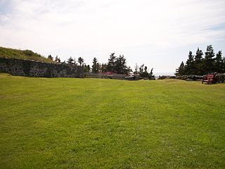
Castle Hill is an area containing the remains of both French and British fortifications, overlooking the town of Placentia in Newfoundland and Labrador, Canada. The site was originally established in order to protect the French fishing interests in Terre-Neuve (Newfoundland) and the approaches to the French colony of Canada.
Southeast Placentia is a settlement in Newfoundland and Labrador. It is part of the Town of Placentia.
Fort Royal is a French fort built in 1687 on the island of Newfoundland during the time of New France.

Fort William was a fort in St. John's built in 1698 to protect English interests on Newfoundland, primarily against French opposition. It was the original headquarters of the British garrison in Newfoundland. A second fort, known as Fort George was situated at the east end of the harbour connected by a subterranean passage with Fort William. On the south side of the Narrows, there was a third fortification called the Castle. Garrison headquarters were later moved to Fort Townshend, which was built between 1775-1779.

Fort Saint Louis was a French fort built in the 17th century on Newfoundland at the time of the New France.
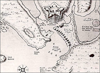
Fort Plaisance was a French fort built in the 17th century on the island of Newfoundland at the time of the New France.
Division No. 1, Subdivision B is an unorganized subdivision on the Avalon Peninsula in Newfoundland and Labrador, Canada. It is in Division 1 and contains the unorganized communities of Iona, Little Barasway, Placentia Junction, Point Verde and Ship Harbour.

Fort Frederick was a British redoubt that was built to help fortify their acquisition of Placentia in Newfoundland Colony. Under the command of Samuel Gledhill, it served as the military headquarters for Newfoundland from 1721 to 1746. There was a report that the Mi'kmaq were involved in a raid of Placentia during Father Rale's War, in which they were said to have killed 200 English. Governor Drummer did not believe the report.

Little Placentia Sound is an abandoned town in Newfoundland and Labrador that had a peak population of 47 in 1901. It is named after the body of water (sound) that encompasses the former community located within Placentia Bay on the Avalon Peninsula in the Canadian province of Newfoundland and Labrador. There was once a lead mine called Silver Cliff Mine located within the town.
This page is based on this
Wikipedia article Text is available under the
CC BY-SA 4.0 license; additional terms may apply.
Images, videos and audio are available under their respective licenses.
