The valley in which Friant Dam and Millerton Lake now lie was once the location of the historic town of Millerton. Millerton was the first county seat of Fresno County.[5][6] In 1880, the first dam on the San Joaquin River was constructed by the Upper San Joaquin Irrigation Company roughly on the present site of Friant Dam. Built of local rock, the dam was an 800-foot (240m) long, 6-foot (1.8m) tall structure designed to divert water for the irrigation of 250,000 acres (100,000ha). The project was abandoned in the wake of floods that destroyed the dam two years later.[7]
Friant Dam was originally proposed in the 1930s as a main feature of the Central Valley Project (CVP), a federal water project that would involve building an expansive system of dams and canals on the rivers of the Central Valley to provide water for agriculture, with secondary purposes of flood control, municipal supply, and hydroelectric power generation.[8] The CVP was authorized by the 1935 Rivers and Harbors Act, while $20 million of initial funding for Friant Dam was provided by the Emergency Relief Appropriation Act of 1935.[9]
Initial surveys of the Friant Dam site were carried out in November 1935 and continued through early 1936. In January 1938, a worker's camp was established near the town of Friant to house the laborers that would ultimately work on the dam. In the middle of the Great Depression, the Friant Dam site saw a huge influx of job seekers, many of whom had to live further away in surrounding cities. More than 50,000 people attended the groundbreaking of the dam on November 5, 1939 in a celebration that is now known as "one of the greatest in San Joaquin Valley history".[10]
Construction
Construction of Friant Dam began with blasting and excavation of the dam site to remove more than 1,200,000 cubic yards (920,000m3) of loose material above the bedrock. Before any concrete was laid on the dam's main wall, the underlying rock was extensively grouted to fill in 725 holes and seams that might otherwise cause instability in the foundation. The concrete used in the dam's construction was made from sand and gravel excavated from the San Joaquin River floodplain about 3 miles (4.8km) below the dam to form Lost Lake. Notably, more than 5,400 ounces (150kg) of placer gold – worth $176,000 at the time – were uncovered in the excavation site.[11] A branch line of the Southern Pacific Railroad delivered this material to a concrete mixing plant, which could produce up to 6,000 cubic yards (4,600m3) of concrete per hour, directly adjacent to the construction site.[12] In July 1940, the San Joaquin River was diverted through a wooden flume so that work on the foundations could begin.[11]
On July 29, the first concrete was poured into the main body of Friant Dam. In order to keep the structure in line, the dam was built in a series of blocks or forms, each measuring 50 feet (15m) square. Concrete was placed via a massive steel trestle system 210 feet (64m) high and 2,200 feet (670m) long, along which ran small powered railcars that delivered buckets of concrete from the mixing plant. Two gantry cranes lifted the buckets from the cars and poured them onto the forms. In summer 1941, the labor force reached a peak of 1,500, and the monthly record for concrete placement, at 228,000 cubic yards (174,000m3), was set in August.[13]
U.S. government photograph of several re-interred Native Americans whose graves had been in the dam's planned reservoir
During the dam's construction several Native American burial sites had their graves removed and re-interred.
The workforce scrambled to complete the main wall of the dam after an act of the War Production Board (WPB) suspended resources in order to assist U.S. military efforts in World War II. The dam was topped out on June 16, 1942, just under two years after the first concrete was poured. However, the spillway gates, the water release valves and the two irrigation canals Friant was intended to support remained unfinished in the wake of the WPB's order.[11]
The war, however, did not completely halt construction. Less than a year later, the WPB "[determined] the completion of the Madera Canal and the installation of valves at the Friant Dam, necessary for war-time food and fiber production" – allowing construction to resume on a limited scale.[11] A pair of control valves were borrowed from Hoover Dam, allowing the closure of the river outlets and Millerton Lake began to fill on February 21, 1944. Work on the Madera Canal, the smaller of the two irrigation canals serviced by Friant Dam (the other, the Friant-Kern Canal, would not be completed for another four years), was completed in 1945 and water ran for its entire length for the first time on June 10, with irrigation deliveries commencing one month later.[11]
The dam was formally dedicated on July 9, 1949 by California governor Earl Warren, who declared that the water furnished by Friant Dam and its canals would help the San Joaquin Valley to "become a modern Eden" as water was released into the partially completed Friant-Kern Canal for the first time.[14] More than three thousand people, mostly residents of the San Joaquin Valley, attended the ceremonies.[15]
[The dam is] but a lifeline to preserve and enhance our American civilization. This is a line of creation, built to unlock the fertility of the rich soil, to resist drought, to overcome floods, to provide outdoor recreation, and to generate cheap power that will improve the living conditions of millions of our citizens." – Secretary of the InteriorHarold Ickes at Friant Dam dedication[15]
Operations and usage
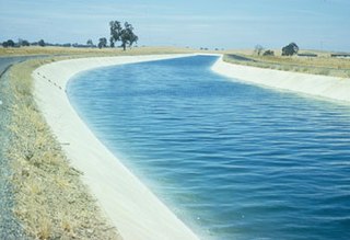
The Friant-Kern Canal, the larger of the two canals supplied with water from Friant Dam
Friant Dam's primary purpose is to capture the fluctuating flows of the San Joaquin River and divert the water for irrigation through the Friant-Kern and Madera Canals. The Friant-Kern Canal is 151.8mi (244.3km) long, extending south from the dam to the Kern River near Bakersfield, and has an initial diversion capacity of 5,000 cubic feet per second (140m3/s); the 35.9-mile (57.8km) Madera Canal, which has a capacity of up to 1,000 cubic feet per second (28m3/s), travels north from the dam to the Chowchilla River. Together, these canals provide irrigation water to some 837,000 acres (339,000ha) of the San Joaquin Valley. In 1990, farmers who received their water from Friant Dam produced more than $1.9 billion worth of 90 different kinds of crops.[2]
Millerton Lake has a capacity of 520,528 acre-feet (642,062dam3) at normal maximum pool, with a surcharge (above spillway gates, but below the dam crest) capacity of approximately 91,000 acre-feet (112,000dam3) for a total capacity of 611,500 acre-feet (754,300dam3). About 170,000 acre-feet (210,000dam3), or 32.7% of the reservoir's regular capacity, is reserved for flood control between October and January to protect against rain floods, while between February and July, this is increased to 390,500 acre-feet (481,700dam3) – 75.0% – to provide space for snowmelt floods.[16] The dam is operated to maintain a flow of 6,500 cubic feet per second (180m3/s) or less on the San Joaquin River at Mendota, 60 miles (97km) downriver. However, large snowmelt floods often exceed the capacity of the dam and reservoir and force larger releases downstream, potentially causing damage to riverside property and infrastructure.[4]
The dam is also used to generate up to 25 megawatts (MW) of hydroelectric power. The penstock releasing water into the Friant-Kern Canal is fitted with a Kaplan turbine with a capacity of 15 MW, and the Madera Canal penstock is equipped with a smaller 8 MW turbine. The smallest hydroelectric generator, with a capacity of 2 MW, is located at the outlet works on the base of the dam and produces power from water releases that serve local farms along the San Joaquin River directly downstream from Friant Dam, as well as releases to a fish hatchery below the dam and for wildlife management purposes.[4]
Expansion
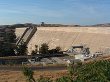
Friant Dam and Millerton Lake in 2006, filled to capacity and releasing floodwater
Because of its relatively small storage capacity relative to the average annual discharge of the San Joaquin River – 520,528 acre-feet (642,062dam3) versus 1,790,000 acre-feet (2,210,000dam3) – Friant Dam often has to release excessive amounts of water that could be otherwise used for irrigation or power generation, also causing downstream damage. From 1981 to 2011, an average of 450,000 acre-feet (560,000dam3) was spilled each year because the reservoir was unable to contain it.[17] The USBR has proposed increasing the height of Friant Dam by up to 140 feet (43m), nearly tripling the reservoir's storage capacity to 1,390,000 acre-feet (1,710,000dam3). A smaller 60-foot (18m) raise would increase storage capacity to 860,500 acre-feet (1,061,400dam3), while a 25-foot (7.6m) raise would increase storage capacity to 652,500 acre-feet (804,800dam3). The increase in height would also allow for the generation of between 4.7–30.4 MW of additional power.[18][19]
Another proposal to increase storage in the upper San Joaquin River basin is Temperance Flat Dam, which would be located in the San Joaquin River canyon upstream of Friant Dam and impound between 460,000 to 2,775,000 acre-feet (567,000 to 3,423,000dam3) of water.[20] The proposed dam would stand 415 to 840 feet (126 to 256m) high above the river, and it would capture most of the floodwater that would otherwise be spilled from Friant Dam. However, Temperance Flat has come under heavy controversy because it would flood a large scenic section of the San Joaquin River gorge, negatively affect wildlife in the river and inundate two upstream hydroelectric power plants, causing a net loss in power generation.[21] The water supplied from such a dam would be very expensive, ranging from $1000–1500 per acre foot (area farmers currently pay about $60 per acre foot). Raising Friant Dam would likely produce similar increases in the cost of irrigation water.[22]
Environmental impacts
By diverting most of the San Joaquin River for irrigation, the Friant Dam has caused about 60 miles (97km) of the river to run dry except in high water years when floodwaters are spilled from the dam. The desiccation of the river has caused the degradation of large stretches of riverside habitat and marshes, and has nearly eliminated the historic chinook salmon run that once numbered "possibly in the range of 200,000 to 500,000 spawners annually".[23] Reduction in flows has also increased the concentration of pesticide and fertilizer runoff in the river contributing to pollution that has further impacted aquatic species.[24]
On September 13, 2006, after eighteen years of litigation, environmental groups, fisherman and the USBR reached an agreement on releasing part of the water currently diverted into the irrigation canals into the San Joaquin River in order to help restore the river and its native fish and wildlife. The first water was released on October 2, 2009 at a rate of 185 cubic feet per second (5.2m3/s).[25] By 2014, these "restoration flows" will be increased to 302,000 acre-feet (373,000dam3) per year, or 417 cubic feet per second (11.8m3/s), on top of the 117,000 acre-feet (144,000dam3) that is currently released for agricultural purposes. However, the river restoration project will cause a 12–20% reduction in irrigation water delivered from Friant Dam.[26]
The San Joaquin River is the longest river of Central California. The 366-mile (589 km) long river starts in the high Sierra Nevada, and flows through the rich agricultural region of the northern San Joaquin Valley before reaching Suisun Bay, San Francisco Bay, and the Pacific Ocean. An important source of irrigation water as well as a wildlife corridor, the San Joaquin is among the most heavily dammed and diverted of California's rivers.
The Kings River, is a 132.9-mile (213.9 km) river draining the Sierra Nevada mountain range in central California in the United States. Its headwaters originate along the Sierra Crest in and around Kings Canyon National Park and form the eponymous Kings Canyon, one of the deepest river gorges in North America. The river is impounded in Pine Flat Lake before flowing into the San Joaquin Valley southeast of Fresno. With its upper and middle course in Fresno County, the Kings River diverges into multiple branches in Kings County, with some water flowing south to the old Tulare Lake bed and the rest flowing north to the San Joaquin River. However, most of the water is consumed for irrigation well upstream of either point.
The Central Valley Project (CVP) is a federal power and water management project in the U.S. state of California under the supervision of the United States Bureau of Reclamation (USBR). It was devised in 1933 in order to provide irrigation and municipal water to much of California's Central Valley—by regulating and storing water in reservoirs in the northern half of the state, and transporting it to the water-poor San Joaquin Valley and its surroundings by means of a series of canals, aqueducts and pump plants, some shared with the California State Water Project (SWP). Many CVP water users are represented by the Central Valley Project Water Association.
Shasta Dam is a concrete arch-gravity dam across the Sacramento River in Northern California in the United States. At 602 feet (183 m) high, it is the eighth-tallest dam in the United States. Located at the north end of the Sacramento Valley, Shasta Dam creates Shasta Lake for long-term water storage, flood control, hydroelectricity and protection against the intrusion of saline water. The largest reservoir in the state, Shasta Lake can hold about 4,500,000 acre-feet (5,600 GL).
New Melones Dam is an earth and rock filled embankment dam on the Stanislaus River, about 5 miles (8.0 km) west of Jamestown, California, United States, on the border of Calaveras County and Tuolumne County. The water impounded by the 625-foot-tall (191 m) dam forms New Melones Lake, California's fourth-largest reservoir, in the foothills of the Sierra Nevada east of the San Joaquin Valley. The dam serves mainly for irrigation water supply, and also provides hydropower generation, flood control, and recreation benefits.
The Delta–Mendota Canal is a 117-mile-long (188 km) aqueduct in central California, United States. The canal was designed and completed in 1951 by the U.S. Bureau of Reclamation as part of the Central Valley Project. It carries freshwater to replace San Joaquin River water which is diverted into the Madera Canal and Friant-Kern Canal at Friant Dam.
Pine Flat Dam is a concrete gravity dam on the Kings River in the Central Valley of Fresno County, California United States. Situated about 28 miles (45 km) east of Fresno, the dam is 440 feet (130 m) high and impounds Pine Flat Lake, in the foothills of the Sierra Nevada just outside the boundary of Kings Canyon National Park. The dam's primary purpose is flood control, with irrigation, hydroelectric power generation and recreation secondary in importance.
San Luis Dam, also known as B.F. Sisk Dam, is a major earth-filled dam in Merced County, California, which forms San Luis Reservoir, the largest off-stream reservoir in the United States. The dam and reservoir are located in the Diablo Range to the east of Pacheco Pass and about 10 miles (16 km) west of Los Banos. San Luis Dam, a jointly-owned state and federal facility, stores more than 2 million acre feet (2.5 km3) of water for the California State Water Project and the federal Central Valley Project. Although the dam is located in the valley of San Luis Creek, the majority of its water comes from man-made aqueducts which are supplied from other rivers in Northern California.
Trinity Dam is an earthfill dam on the Trinity River located about 7 miles (11 km) northeast of Weaverville, California in the United States. The dam was completed in the early 1960s as part of the federal Central Valley Project to provide irrigation water to the arid San Joaquin Valley.
The California State Water Project, commonly known as the SWP, is a state water management project in the U.S. state of California under the supervision of the California Department of Water Resources. The SWP is one of the largest public water and power utilities in the world, providing drinking water for more than 27 million people and generating an average of 6,500 GWh of hydroelectricity annually. However, as it is the largest single consumer of power in the state itself, it has a net usage of 5,100 GWh.
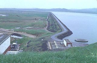
Millerton Lake is an artificial lake near the town of Friant, about 15 mi (24 km) north of downtown Fresno, California, United States. The reservoir was created by the construction of 319 ft high Friant Dam on the San Joaquin River which, with the lake, serves as much of the county line between Fresno County to the south and Madera County to the north.
Auburn Dam was a proposed concrete arch dam on the North Fork of the American River east of the town of Auburn, California, in the United States, on the border of Placer and El Dorado Counties. Slated to be completed in the 1970s by the U.S. Bureau of Reclamation, it would have been the tallest concrete dam in California and one of the tallest in the United States, at a height of 680 feet (210 m) and storing 2,300,000 acre-feet (2.8 km3) of water. Straddling a gorge downstream of the confluence of the North and Middle Forks of the American River and upstream of Folsom Lake, it would have regulated water flow and provided flood control in the American River basin as part of Reclamation's immense Central Valley Project.
The Friant-Kern Canal is a 152 mi (245 km) aqueduct managed by the United States Bureau of Reclamation in Central California to convey water to augment irrigation capacity in Fresno, Tulare, and Kern counties. A part of the Central Valley Project, canal construction began in 1949 and was completed in 1951 at a cost of $60.8 million.
The Madera Canal is a 35.9 mi (57.8 km)-long aqueduct in the U.S. state of California. It is part of the Central Valley Project managed by the United States Bureau of Reclamation to convey water north to augment irrigation capacity in Madera County. It was also the subject of the United States Supreme Court's decision in Central Green Co. v. United States.
The Rio Grande Project is a United States Bureau of Reclamation irrigation, hydroelectricity, flood control, and interbasin water transfer project serving the upper Rio Grande basin in the southwestern United States. The project irrigates 193,000 acres (780 km2) along the river in the states of New Mexico and Texas. Approximately 60 percent of this land is in New Mexico. Some water is also allotted to Mexico to irrigate some 25,000 acres (100 km2) on the south side of the river. The project was authorized in 1905, but its final features were not implemented until the early 1950s.
New Exchequer Dam is a concrete–faced, rock-fill dam on the Merced River in central California in the United States. It forms Lake McClure, which impounds the river for irrigation and hydroelectric power production and has a capacity of more than 1,000,000 acre-feet (1.2 km3). The Merced Irrigation District (MID) operates the dam and was also responsible for its construction.
O'Neill Dam is an earthfill dam on San Luis Creek, 12 miles (19 km) west of Los Banos, California, United States, on the eastern slopes of the Pacific Coast Ranges of Merced County. Forming the O'Neill Forebay, a forebay to the San Luis Reservoir, it is roughly 2.5 miles (4.0 km) downstream from the San Luis Dam.
New Don Pedro Dam, often known simply as Don Pedro Dam, is an earthen embankment dam across the Tuolumne River, about 2 miles (3.2 km) northeast of La Grange, in Tuolumne County, California. The dam was completed in 1971, after four years of construction, to replace the 1924 concrete-arch Don Pedro Dam.
Temperance Flat Dam is a proposed dam project on the San Joaquin River west of Auberry, California. Construction of the dam is on hold. The dam's main purpose would be to supplement storage capacity in the upper San Joaquin River basin. Under the current proposal, Temperance Flat would slightly more than double water storage on the San Joaquin River from below Friant Dam. The project is highly controversial because it would flood scenic canyons and historic sites along the San Joaquin River, and impact upstream hydroelectricity generation. The Bureau of Reclamation estimates the construction costs will be between US$2.5 billion and $2.6 billion, while other estimates range from $2.96 billion up to $3.35 billion. At 665 feet (203 m), Temperance Flat Dam would be the second highest dam in California, and the fifth tallest dam in the United States.
Red Bluff Diversion Dam is a disused irrigation diversion dam on the Sacramento River in Tehama County, California, United States, southeast of the city of Red Bluff. Until 2013, the dam provided irrigation water for two canals that serve 150,000 acres (61,000 ha) of farmland on the west side of the Sacramento Valley. The dam and canals are part of the Sacramento Canals Unit of the Central Valley Project, operated by the U.S. Bureau of Reclamation. In 2013, the dam was decommissioned and the river allowed to flow freely through the site in order to protect migrating fish. A pumping plant constructed a short distance upstream now supplies water to the canal system.
↑ Ritzema, Randall S.; Newlin, Brad D.; Van Lienden, Brian J. (October 2001). "Appendix H: Infrastructure"(PDF). CALVIN Project. University of California Davis. Archived from the original(PDF) on 2017-11-06. Retrieved 2014-01-25.
↑ "Water For A New Eden: The Friant-Kern Canal answers prayers of farmers who work some of California's richest but thirstiest land". Life. Vol.27, no.4. 1949-07-25. p.25.
↑ Yoshiyama; etal. (2001). "Historical and present distribution of chinook salmon in the Central Valley drainage of California". Contributions to the Biology of Central Valley Salmonids, Fish Bulletin. 179: 309–362.
Billington, David P.; Jackson, Donald C.; Melosi, Martin V. (2005). The History of Large Federal Dams: Planning, Design, and Construction. Government Printing Office. ISBN0-16072-823-1.
Brewer, Chris (2001). Historic Kern County: An Illustrated History of Bakersfield and Kern County. San Antonio, TX: HPN Books. ISBN1893619141.
External links
Wikimedia Commons has media related to Friant Dam.
This page is based on this Wikipedia article Text is available under the CC BY-SA 4.0 license; additional terms may apply. Images, videos and audio are available under their respective licenses.