Related Research Articles

East Sussex is a ceremonial county in South East England. It is bordered by Kent to the north-east, West Sussex to the west, Surrey to the north-west, and the English Channel to the south. The largest settlement is the city of Brighton and Hove, and the county town is Lewes.

West Sussex is a ceremonial county in South East England. It is bordered by Surrey to the north, East Sussex to the east, the English Channel to the south, and Hampshire to the west. The largest settlement is Crawley, and the county town is the city of Chichester.

Ditchling is a village and civil parish in the Lewes District of East Sussex, England. The village is contained within the boundaries of the South Downs National Park; the order confirming the establishment of the park was signed in Ditchling.

Hassocks is a village and civil parish in the Mid Sussex District of West Sussex, England. Its name is believed to derive from the tufts of grass found in the surrounding fields.

Preston Park railway station is on the Brighton Main Line in England, serving Preston Village and the northern suburban areas of the city of Brighton and Hove, East Sussex. It is 49 miles 21 chains (79.3 km) from London Bridge via Redhill, between Hassocks and Brighton.

Hassocks railway station is on the Brighton Main Line in England, serving the village of Hassocks, West Sussex. It is 43 miles 42 chains (70.0 km) down the line from London Bridge via Redhill and is situated between Burgess Hill and Preston Park. It is managed by Southern.

Barcombe is an East Sussex village and civil parish in the Lewes District of East Sussex. The parish has four settlements: old Barcombe, the oldest settlement in the parish with the parish church; Barcombe Cross, the more populous settlement and main hub with the amenities and services; the hamlet of Spithurst in the northeast and Town Littleworth in the northwest.

Arlington is a village and civil parish in the Wealden district of East Sussex, England. The parish is on the River Cuckmere, and is the location of a medieval priory, a reservoir and a car racetrack.
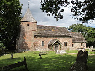
East Chiltington is a village and civil parish in the Lewes District of East Sussex, England. It is centred four miles (5.9 km) south-east of Burgess Hill and five miles (8 km) north-west of Lewes. It is a strip parish of 3.76 square miles (9.7 km2), stretching northward from the crest of the South Downs. The village church is 13th century in origin; the vicar also has charge of two churches in Plumpton. Near the church there is a pub called The Jolly Sportsman. The Sussex Greensand Way, a Roman road, runs from east to west through the centre of the parish.

Hamsey is a village and civil parish in the Lewes district of East Sussex, England. The parish covers a large area and also consists of the villages Offham and Cooksbridge. The main centres of population in the parish are now Offham and Cooksbridge. Around the main settlements are enlarged fields, isolated old cottages and farms. The winding and undulating parish lanes between banks, old hedge rows, trees, flowery verges and ditches are popular with cyclists and give good views of the Downs. In 2011 the parish had a population of 632.

Plumpton is a village and civil parish in the Lewes District of East Sussex, England. The village is located 5 mi (8.0 km) north-west of Lewes. The parish measures 6.5 mi (10.5 km) in length on its north–south axis and 1 mi (1.6 km) at its widest on the B2116 Underhill Road. The southern half of the parish lies within the South Downs National Park and at the highest point, 214 m (702 ft), the South Downs Way traverses the crest of Plumpton Plain. The parish includes the small village of Plumpton adjacent to the Downs and to the north the larger village of Plumpton Green where most of the community and services are based. Plumpton is known for its race course, and also Plumpton College, which farms over 2,500 acres (1,000 ha) of land and has become one of the leading centres for land-based education in the UK.

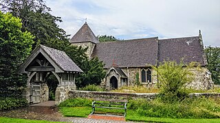
Westmeston is a village and civil parish in the Lewes District of East Sussex, England heavily dependent in amenities on larger Ditchling to the near-immediate northwest. It is four miles (6 km) south-southeast of Burgess Hill and (10 km) west of Lewes, on the northern slopes of the South Downs.

Streat is a village and parish in the Lewes district of East Sussex, England, 3 miles (4.8 km) south-east of Burgess Hill and 5 miles (8.0 km) west of Lewes, within the South Downs National Park.
Twineham is a village and civil parish in the Mid Sussex District of West Sussex, England. It is located eight kilometres to the west of Burgess Hill. The civil parish covers an area of 784 hectares In the 2001 census 271 people lived in 100 households, of whom 139 were economically active. The 2011 Census population was 306.

Mile Oak is a locality forming the northern part of the former parish of Portslade in the northwest corner of the city of Brighton and Hove, England. Now mostly residential, but originally an area of good-quality agricultural land, it covers the area north of Portslade village as far as the urban boundary.

Goddards Green is a hamlet in the Mid Sussex District of West Sussex, England. It is in the civil parish of Hurstpierpoint and Sayers Common, and lies just off the A2300 road 1.7 miles (2.8 km) west of Burgess Hill.

The Sussex Border Path is a long-distance footpath around the borders of Sussex, a historic county and former medieval kingdom in southern England. The main path is 150 miles (240 km) long and stays close to Sussex's borders with Hampshire, Surrey and Kent, connecting Thorney Island to Rye. There is also an additional 33-mile (53 km) spur known as the Mid Sussex Link, which links East Grinstead with Fishersgate and Mile Oak on the western boundary of the city of Brighton and Hove.
The Sussex Greensand Way is a Roman road that runs east-west linking the London to Lewes Way at Barcombe Mills to Stane Street at Hardham. The road, which has almost entirely fallen out of use, follows the free draining ridge of greensand which lies north of the South Downs. It is a planned route rather than a Romanised Iron Age track, following a few straight alignments without any steep gradients, which linked various north-south roads and tracks. A number of important Roman villas and their farming estates were linked by the road. It is not known at what time during the Roman period the road was built.

The London to Brighton Way, also called the London to Portslade Way, is a Roman road between Stane Street at Kennington Park and Brighton in Sussex. The road passes through Streatham and Croydon, then through the Caterham Valley gap in the North Downs. It passes through Godstone and Felbridge, then follows an almost straight line through Ardingly, Haywards Heath, Burgess Hill and Hassocks to the South Downs at Clayton. At Hassocks it crosses the Sussex Greensand Way at a large Roman cemetery. It climbs the South Downs escarpment, crossing the ridgeway and connecting with other local tracks. South of Pyecombe the route is uncertain, and may have continued to Brighton or to Portslade.

Worthing is a large seaside town in Sussex, England in the United Kingdom. The history of the area begins in Prehistoric times and the present importance of the town dates from the 19th century.
References
- ↑ "South Downs National Park Authority, neighbourhood area designations" (PDF).[ permanent dead link ]
- ↑ Saxon Settlement and Earlier Remains at Friars Oak, Hassocks, West Sussex. British Archaeological Reports (BAR) British. 4 Apr 2000. ISBN 978-1841710525.
- ↑ Margary, Ivan D (1948). Roman Ways in the Weald. Littlehampton Book Services Ltd. p. 296. ISBN 978-0460077422.
- ↑ "Rodney Stone at Project Gutenberg". Archived from the original on 2014-10-07. Retrieved 2014-11-16.