From 1577 to 1580 Sir Francis Drakecircumnavigated the world. In 1579 as part of this voyage he landed on the west coast of North America which consequently has drawn the attention of scores of historians, geographers, linguists, anthropologists and other professionals. In addition, many history buffs have sought to locate Drake's New Albion. The established site for Drake's 1579 landing at New Albion is at Drake's Cove in Drakes Bay in Marin County, California (38.034°N 122.940°W). More than a score of ideas for an alternative to Drake's New Albion claim have been put forth which cover the coast from Alaska to Baja California Sur, Mexico. These ideas span the eighteenth through the early twenty-first centuries.
Fringe theories are ideas which depart significantly from a prevailing or mainstream theory. A fringe theory is neither a majority opinion nor that of a respected minority.[1] Financial journalist Alexander Davidson characterized fringe theories as "peddled by a small band of staunch supporters," but not necessarily without merit.[2]
Established site
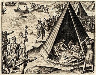
National Historic Landmark commemorating Sir Francis Drake, Sebastian Rodriguez Cermeño, and Coast Miwok people at Point Reyes, California
More than twenty other locations have been advanced as the site of Drake's port.[8]Davidson recognized a plethora of confusion from chiefly armchair historians including Samuel Johnson[9] and Jules Verne.[10][11] Brian Kelleher has published the most extensive listing of individual's opinions of the Drake landing site comprising over 140 people.[12]
Some writers have suggested that Queen Elizabeth's desire to maintain secrecy of the locations and extent of Drake's north Pacific explorations led to suppression and obfuscation of the reports.[13][14] The defeat of the Spanish Armada by Drake in 1588 obviated the need for any secrecy. Michael Turner's visits to Drake sites around the world show that the records are very accurate.[15][16]
Following the coast from north to south, there are many suggested alternative locations.
Alaska
There are several theories that place Drake's New Albion at various places along the Alaskan coast.
Laird Nelson proposed that Drake sailed as far north as Prince William Sound, Alaska 60°00′N146°30′W / 60°N 146.5°W / 60; -146.5 based on the westward run of the land in the area. Laird believes Drake was at 58 degrees north and "may have been even further north."[18] Drake then turned south to anchor at Birch Bay, Washington.
There are several theories that place Drake's New Albion at various places along the British Columibian coast.
Victoria, Vancouver Island, BC
In December, 2013, metal detector operator Bruce Campbell found an English coin made between 1551 and 1553 near Victoria, British Columbia. While Campbell believes the coin is only the oldest thing he's likely to ever find, and Royal British Columbia Museum curator Grant Keddie did not believe the find can be connected to Drake. Loose finds such as coins have little value in establishing landing sites.
Comox Bay, Vancouver Island, BC
In 2003 Canadian R. Samuel Bawlf suggested[19] that Drake's New Albion was Vancouver Island and that Drake erected a post containing such a proclamation at what is today Comox, British Columbia, located on Vancouver Island.[20]49°40′N124°57′W / 49.66°N 124.95°W / 49.66; -124.95 Bawlf supports the idea that Drake completed the "Neahkahnie Mountain Survey" and believes Drake careened the Golden Hind in Whale Cove, Oregon. He points to a number of pieces of evidence in support of his view that the official published record of Drake's voyage was deliberately altered to suppress the true extent of his discoveries. Bawlf also relies heavily upon the configuration of the coastline as depicted in some of the maps and globes of the era, including the so-called French and Dutch Drake Maps which depict his voyage as having reached a point northward of a chain of islands to the northwest of New Spain and other maps depicting New Albion at latitudes above those of northern California, such as Richard Hakluyt's 1587 map of the New World showing Nova Albion at 50 degrees north latitude. Bawlf also placed emphasis on the fact that, on an initial rendition of his globe in 1592, Emery Molyneux depicted the line of the coast of North America behind Vancouver Island with remarkable accuracy, although the islands themselves, depicted on the French and Dutch Drake maps, do not appear.
Although Bob Ward initially drew some of the discrepancies between the official published accounts of Drake's voyage and other documents to Bawlf's attention, and concluded that Drake likely sailed much farther to the north than northern California, he has been critical of some of Bawlf's conclusions, such as Drake's erecting a post proclaiming New Albion at what is now Comox Bay.
Bawlf's claims regarding "spectral analysis" and four matching islands have been disputed by Derek Hayes.[21] Oliver Seeler disputes Bawlf's conclusions,[22][23][24] as does Eric Powell.[25]
Bawlf's work has also been criticized by Edward Von der Porten, who calculated that Bawlf's theory requires the Golden Hinde to have traveled "an average of 5.95 knots [...] in a ship capable of less than one knot in those conditions." Further, Bawlf fails to identify the white cliffs, the Islands of St. James or the Coast Miwok People. Von der Porten states that Bawlf "has no evidence for either the conspiracy or his 'ten degree rule.'"[26][27]
Dr. John Sugden describes Bawlf's proposed route for Drake into Alaska and British Columbia, then concludes: "There is simply no evidence for this adventure, which even Bawlf admits is 'impossible' to reconcile with the records of the voyage."[28]
There are several theories that place Drake's New Albion at various places along the Washington coast.
Birch Bay, Washington
Fisherman Laird Nelson has proposed that Drake left Guatulco, Mexico, headed west 2,100 miles, then magnetic north for 2,700 miles with three ships: the un-renamed Pelican; the Los Reyes, a captured Spanish vessel; and a pinnace. From that point, the ships travelled an additional 550 miles north to Prince William Sound and back along the coast.[31] The ships then travelled 700 miles south through the Inside Passage to the first of three landing sites: Birch Bay. 48°55′N122°47′W / 48.92°N 122.78°W / 48.92; -122.78 Here, on the third day, the Pelican sank.[32]
Nelson does not explain how Drake could have covered 5,350 miles west and north when The World Encompassed establishes the distance traveled as 1,400 English 16th-Century leagues which is only 4,000 miles. (Laird's distance of 4,800 miles for the west and first portion north is equivalent to 1,400 modern leagues.)[33] Laird's proposal has Drake traveling the entire distance and dangerous Inside Passage at surprising speed, covering the 6,600 miles in 62 days.
Lummi Bay, Washington
Nelson proposed that after the loss of his flagship, Drake explored in a small boat for five days and then moved the Los Reyes to a second port at Lummi Bay, Washington.48°46′N122°40′W / 48.77°N 122.67°W / 48.77; -122.67 .[34] Here Drake careened the Los Reyes.
Sandy Point, Washington
Nelson puts Drake's second anchorage at Sandy Point, Washington, a part of Lummi Bay, where Drake reportedly spent the second week of his New Albion visit.48°44′N122°32′W / 48.73°N 122.54°W / 48.73; -122.54[35] At Post Point, within Bellingham Bay, Drake created his "monument", a rock carvings in the cliff face of King Henry VIII and his sixth wife Katherine Parr. Initials attributed to the carver, Richard Cadwell were inscribed. The 3 ton rock carvings have been knocked down, but still there in 2000. The Plate of Brasse refers to the "thick coat of bottom paint" the carver put over the carvings.[36]
Garry Gitzen has continued to support this idea.[40] Gitzen claims the "Neahkahnie Mountain Survey," the Hondius Map, the Edward Wright World Chart of 1599,[41] the Nehalem Indians and the Three Arch Rocks prove Drake's landing site was in Nehalem Bay, Oregon as well as the Indian culture of the Pacific Northwest.[42]
Gitzen argues that the "Survey" is a formal survey by Robert Schultz A.S.C.E and Phillip Costaggini's 1981 Oregon State thesis "Survey of Artifacts at Neahkahnie Mountain Oregon (1976-1981)" of the coastal area two to four miles north of Nehalem Bay encompassing the area up to one mile over the countryside of Neahkahnie Mountain. The incised rocks and carins are explained as recordings of a land survey and latitude showing angles and bearings in "The Treasure Rocks of Neah-kah-nie Mountain (2012).[citation needed], the "W" rock which has components that "represent a combination of sun and star sighting points to determine the longitude, date and time and day," and the "Rays Rock" which "is a compass rose point used to measure points on Neahkahnie Mountain and beyond.".[citation needed]
Gitzen claims the outline and topography of Nehalem Bay match the Hondius Map, and that the Islands of Saint James are the Three Arch Rocks 13 miles south of the entrance to Nehalem Bay.
An article "Edward Wright's World Chart 1599 published in the blind peer-review "Terrae Incognitae" journal of the Society for the Histories of Discoveries contains Queen Elizabeth's Privy Seal. The only such map of the 16th century to carry the Queen's seal. The map was originally published in 1599 by Richard Hakluyt and reissued by the Hakluyt Society's 2 volume publication "The Hakluyt Handbook"(1974) where it is identified by David Beers Quinn, editor, and Helen Wallis, Map Curator of the British Museum, both agree the map is the most authentic map Hakluyt published in his books.
Whale Cove, Lincoln County, Oregon
In 1978 British amateur historian Bob Ward, after making a study of the geography of the Pacific coast of the U.S. and Canada, and a single visit to the site,[43] suggested that Drake actually landed much farther north, in Whale Cove in present-day Oregon.44°47′20″N124°04′14″W / 44.788944°N 124.070689°W / 44.788944; -124.070689 Advocates of the Whale Cove theory argue that when Captain James Cook first sighted the American coast at Cape Foulweather two centuries later, he described it in his log, with unknowing accuracy, as "the long-looked for coast of New Albion." Whale Cove lies just north of Cape Foulweather. Advocates of the Whale Cove theory dismiss the latitude given by Drake on the grounds that he may have deliberately falsified it in order to deceive the rival Spanish. Although the official account of Drake's voyage gives the anchorage location as 38 degrees, the only two known hand-written accounts of the voyage, preserved in the British Library, say that it was at 44 degrees, which is on the mid-Oregon coast. Drake and Queen Elizabeth, they argue, falsified the location because he mistakenly thought he had discovered the North West Passage when he found, and sailed into, the Strait of Juan de Fuca, which today separates Vancouver Island, British Columbia from the mainland Olympic Peninsula of Washington state.[44][45] In 2012, Ward established a website supporting Whale Cove.[46]
Melissa Darby has established the Drake Anchorage Research Collaboration (DARC) in support of the possible Whale Cove landing site,[47] although she says she "can not say for sure where he (Drake) was."[48]
Whale Cove is the site identified by Bawlf as Drake's careening location.
Ward, Bawlf and Darby do not agree on the general route taken by Drake, but all have Drake's careening site at Whale Cove.
Whale Cove remains an unnavigable bay in a dangerous part of the Oregon coast: mariners are advised to stay at least 600 yards offshore for the distance one mile north of Whale Cove to one mile south of Whale Cove. Whale Cove is not considered a usable bay by any size of vessel.[49]
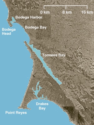
Several ideas that Drake entered Bodega Bay have been put forth. Two specified actual landing sites.
In the 19th century, a number of observers argued that Bodega Bay was the site of Drake's New Albion. One of the most prominent of these was Alexander von Humboldt, who, however, had never been in California."[55]
In 1894, Edward Berthould wrote in National Geographic that the geography of Bodega Head and its proximity to the Farallon Islands seem to point to Bodega Bay as Drake's landing site.[56]
Bob Graham has evaluated the reported latitudes and the technologies available to Drake. If the 38-1/2 degree value is more accurate than the 38 degree value, and if Drake took a scientific series of experimental data and averaged it (for which there is no evidence), then the Bodega Bay latitude is more likely to be right than the Drakes Bay latitude.[57] In comparison to other reported Drake latitudes across the globe, the reported latitudes establish that Drake's harbor was within 1/2 degree of 38 degrees north latitude or 38-1/2 degrees north latitude based on average errors.[58]
Campbell Cove, Bodega Bay, Sonoma County, California
John W. Dwinelle suggested Drake careened his ship in the northern center of Bodega Bay. The white cliffs were assumed to be sand dunes. The natural harbor lacks sufficient depth for the Golden Hind.[60]
One of San Francisco's earliest historians, Frank Soule, wrote in support of a Drakes Bay landing site.[62] George Davidson concluded that Drake was at Drakes Bay, but believed the actual careening point was just inside Point Reyes Head. 37°59′38″N122°58′26″W / 37.994°N 122.974°W / 37.994; -122.974 Davidson's work was based on sailing the coast. The identification of the careening point required exploring the site the way the artist of the Hondius Broadside inset viewed the site.[63]
Several early claims put Drake in San Francisco Bay, but did not establish where in the Bay Drake visited and then careened the Golden Hind. These include Robert Greenhow in 1845, Jules Verne in 1879[67][68] and Samuel Johnson.
Laurence Bergreen believes Drake entered San Francisco Bay, but fails to address any details of the navigation, landing, or site or to explain Drake's apparent failure to explore the extensive inland waterway as the possible Strait of Anian.[69][70]
Modern San Francisco Bay landing ideas share several important clues with the accepted Drakes Bay site: meeting with the Coast Miwok people, latitude close to 38°north and proximity to the Farallon Islands.
These landing ideas also claim that after sailing 400 miles down the Oregon and California coasts unsuccessfully seeking a harbor, Drake saw Drakes Bay and the white cliffs in the excellent bay, but continued past the harbor.
The new ideas suggest birds above the inland from Drakes Bay suggested the harbor of San Francisco Bay[71] or that the Spanish had earlier surveyed San Francisco Bay and that Drake had those maps.[72]
The new ideas ignore the difficulty of finding the Bay from the sea including the fog and islands which make the entrance to the Golden Gate nearly invisible.
The entrance to San Francisco Bay is dangerous and none of the accounts discuss the shoals and difficulties of entering the Bay, especially on an unknown basis.
The accounts indicate that there was a single anchorage within the harbor, not the scores of possible sites for a mariner within San Francisco Bay.
Except for the entrance to the Bay, the San Francisco Bay shoreline is warm or even hot on summer days, far different from the continuous cold and fog reported by Drake.
Late in the five-week stay, Drake took a trip up and into the interior of the country which was found to be far different. This corresponds to a coastal site, not a site within San Francisco Bay.
Had Drake entered San Francisco Bay, he would have spent weeks exploring up the Sacramento and San Joaquin Rivers in the belief that the Strait of Anian had, indeed been found. He would have reported one of the world's most important bays. Neither of these occurred.
All of the specific proposed landing sites, below, within San Francisco Bay are north of the Golden Gate. Holmes reports that if Drake had entered San Francisco Bay, the summer winds would have forced Drake to find a harbor south of the Golden Gate.[73]
Strawberry Cove, Marin County, California
Duane Van Dieman developed a notion that Drake entered San Francisco Bay and careened the Golden Hinde at Strawberry Cove. 37°53′17″N122°30′40″W / 37.888°N 122.511°W / 37.888; -122.511 Van Dieman relies on the Hondius Broadside insert being a formal overhead map which does not correspond with the conventions of the 16th century or the other Hondius inserts. Van Dieman ignores the other problems with all San Francisco Bay claims including the multiple harbors, the lack of continuous fog, the difficulty of finding San Francisco Bay from the sea and the dangers of entering San Francisco Bay on an unknown basis.[74][75][76]
Robert H. Power (1926–1991), co-owner of the Nut Tree in Vacaville, CA, promoted the idea that Drake's New Albion was inside San Francisco Bay near Point San Quentin.37°56′22″N122°29′12″W / 37.939400°N 122.486700°W / 37.939400; -122.486700 Among his arguments was that the Hondius Broadside map matched a part of the topography when parts were adjusted using a 2:1 correction.[82] Among the problems with Power's idea is the difficulty of sailors finding San Francisco Bay from the ocean (it was first discovered by land and the first sea attempts to then locate the Bay failed), the lack of continuous foggy weather,[83] the multitudes of good harbors, and the extreme dangers of entering such a bay on an unknown basis.
To support his idea, Power formed an organization called Nova Albion Explorations which supported investigative work including archaeology of San Francisco Bay Shellmounds. The excavations "did not reveal any historic material which would lead anyone to believe the site experienced any contact with Caucasian parties of the 16th century."[84]
A. Bray Dickinson supported an upper San Francisco Bay site in 1954.[85][86]
Walter Starr and Francis Farquhar supported the San Quentin site.[87]
Olompali, Petaluma River, Marin County, California
Robert C. Thomas advocates that Drake landed at Olompali, on the Petaluma River, inside San Francisco Bay.[71] "Under the shelter of cliffs" at Drakes Bay, Thomas believes Drake's men saw seagulls that rode east on updrafts, so that the men "could see that the land over which they (the birds) were flying was really a peninsula (a Marin County peninsula formed by the Pacific coast and San Francisco Bay.)" "The home-bound gulls swept inland" to Olomp-ali. Thomas dismisses the likelihood that Drake stayed at Drakes Bay, but instead headed south.
Thomas believes that while "there appeared to be no break in the shoreline" showing San Francisco Bay, Drake ran into a "strong current." Risking "imminent danger," Drake "was committed to an uncontrollable approach" and then "miraculously...found that they had passed through..." the Golden Gate.
According to Thomas, over the next five days, Drake explored the 21 nautical miles in the northwest portion of San Francisco Bay, ignored numerous promising harbors, and moved "his ship on June 21" to Chok-olom, the port near Olomp-ali.38°07′08″N122°30′54″W / 38.119°N 122.515°W / 38.119; -122.515
Thomas glosses over the fact that the Marin "peninsula" is not visible or discernible from the coast. Thomas does not solve the problems with any proposed San Francisco Bay Drake landing site: the difficulty of sailors finding San Francisco Bay from the ocean (it was first discovered by land and the first sea attempts to then locate the Bay failed), the lack of continuous foggy weather, the multitudes of good harbors, and the extreme dangers of entering such a bay on an unknown basis. Thomas also proposes that Drake sailed inland a significant distance quickly without it being noted in any of the accounts
Grizzly Bay, Suisun Bay, Solano County, California
There are several theories that place Drake's New Albion at various places along the Mexican coast.
Cedros Island, Baja California Norte, Mexico
Harry Kelsey speculates that Drake did not head out to sea on a northerly course. Instead, Kelsey guesses that Drake coasted north to the known Spanish areas near the Baja California Sur and Baja California Norte border coastal area. Three possible sites are identified without any detailed analysis and no specific harbors are found. Cedros Island is the northernmost of these ideas.28°11′N115°13′W / 28.19°N 115.21°W / 28.19; -115.21[102]
Sir Francis Drake was an English explorer and privateer best known for his circumnavigation of the world in a single expedition between 1577 and 1580. This was the first English circumnavigation, and third circumnavigation overall. He is also known for participating in the early English slaving voyages of his cousin, Sir John Hawkins, and John Lovell. Having started as a simple seaman, in 1588 he was part of the fight against the Spanish Armada as a vice-admiral.
Inverness is an unincorporated community and census-designated place (CDP) in western Marin County, California, United States. It is located on the southwest shore of Tomales Bay 3.5 miles northwest of Point Reyes Station and about 40 miles (65 km) by road northwest of San Francisco, at an elevation of 43 feet. In the 2020 census, the population was 1,379. The community was named by a Scottish landowner after Inverness in Scotland.
New Albion, also known as Nova Albion, was the name of the continental area north of Mexico claimed by Sir Francis Drake for England when he landed on the North American west coast in 1579. This claim became the justification for English charters across America to the Atlantic coast and soon influenced further national expansion projects on the continent. Drake's landing site has been identified as Drake's Cove, which is part of Point Reyes National Seashore.
Whale Cove is a small cove, approximately one-third of a mile (0.5 km) in diameter, located on the Pacific Coast of Oregon in the United States, approximately 1.4 mi (2.3 km) south of the city of Depoe Bay. The cove is located at approximately 44 deg 44 min N latitude.
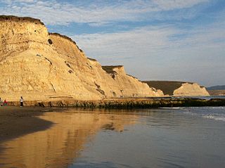
Drakes Bay is a 4 mi (6 km) wide bay named so by U.S. surveyor George Davidson in 1875 along the Point Reyes National Seashore on the coast of northern California in the United States, approximately 30 mi (50 km) northwest of San Francisco at approximately 38 degrees north latitude. The bay is approximately 8 mi (13 km) wide. It is formed on the lee side of the coastal current by Point Reyes. The bay is named after Sir Francis Drake and has long been considered Drake's most likely landing spot on the west coast of North America during his circumnavigation of the world by sea in 1579. An alternative name for this bay is Puerto De Los Reyes.
Bolinas Bay is a small bay, approximately 5 miles (8 km) long, on the Pacific coast of California in the United States. It is in Marin County, north of the Golden Gate, approximately 15 miles (25 km) northwest of San Francisco. The town of Bolinas is at its shore.
Drakes Estero is an expansive estuary in the Point Reyes National Seashore of Marin County on the Pacific coast of northern California in the United States, approximately 25 miles (40 km) northwest of San Francisco.
Point Reyes is a prominent cape and popular Northern California tourist destination on the Pacific coast. Located in Marin County, it is approximately 30 miles (50 km) west-northwest of San Francisco. The term is often applied to the Point Reyes Peninsula, the region bounded by Tomales Bay on the northeast and Bolinas Lagoon on the southeast. The majority of the peninsula as well as the headlands are protected as part of Point Reyes National Seashore.
Bodega Head is a small promontory on the Pacific coast of northern California in the United States. It is located in Sonoma County at 38.311°N 123.066°W, approximately 40 mi (64 km) northwest of San Francisco and approximately 20 mi (32 km) west of Santa Rosa.
Bodega Harbor is a small, shallow, natural harbor on the Pacific coast of northern California in the United States, approximately 40 mi (64 km) northwest of San Francisco. The harbor is approximately 2 sq mi (5.2 km2) in area.
The Federated Indians of Graton Rancheria, formerly known as the Federated Coast Miwok, is a federally recognized American Indian tribe of Coast Miwok and Southern Pomo Indians. The tribe was officially restored to federal recognition in 2000 by the U.S. government pursuant to the Graton Rancheria Restoration Act.
In 1579, Francis Drake was halfway during his circumnavigation and sailed out in the Pacific, then turned east seeking the Strait of Anián , or for a place to repair his ships.
Montara State Marine Reserve (SMR) and Pillar Point State Marine Conservation Area (SMCA) are two adjoining marine protected areas that extend offshore from Montara to Pillar Point in San Mateo County on California’s north central coast. The combined area of these marine protected areas is 18.42 square miles (47.7 km2), with 11.76 square miles (30.5 km2) in the SMR and 6.66 in the SMCA. Montara SMR prohibits the take of all living marine resources. Pillar Point SMCA prohibits the take of all living marine resources, except the recreational and commercial take of pelagic finfish by trolling or seine, the commercial or recreational take of Dungeness crab by trap and the commercial or recreational take or market squid by hand-held dip net or round haul net.
The Drake Navigators Guild is the historical research group which has used multi-disciplinary methods to research Francis Drake’s visit to the west coast of North America in 1579 and related maritime explorations. Founded in 1949, the Guild’s research supports the long-standing conclusion that Drake’s “Nova Albion” is at Drakes Bay, California. The Guild's efforts build on the research of Professor George Davidson (geographer) and others who have studied Drake's voyage. The Guild’s research has identified the specific careening site at Drake’s Cove within the Bay.
Mount Sir Francis Drake, 2,705 metres (8,875 ft), is a mountain in the Pacific Ranges of British Columbia, Canada, standing above the south side of Waddington Harbour and the head of Bute Inlet on the Central Coast of British Columbia just south of the mouth of the Homathko River as it empties into that harbour and inlet.
The Golden Hinde is a full-size replica of the Golden Hind. She was built using traditional handicrafts at Appledore, in Devon. She has travelled more than 140,000 mi (230,000 km), a distance equal to more than five times around the globe. Like the original ship, she has circumnavigated the globe.
N. de Morena or N. de Morera, name given to him by his contemporary Fray Juan de Torquemada and by most authors, was a European ship pilot in the 1577–1580 expedition of Sir Francis Drake. In ill health, he was reportedly left at New Albion in 1579 and once he recovered he walked to Mexico. In doing so, he likely was the first European to see San Francisco Bay and likely established the incorrect idea that California was an island. In only few and non-contemporaneous references, the name is given as "N. de Morena."
Francis Drake's circumnavigation, also known as Drake's Raiding Expedition, was an important historical maritime event that took place between 15 December 1577 and 26 September 1580. The expedition was authorised by Queen Elizabeth I and consisted of five ships led by Francis Drake. Termed a 'voyage of discovery', it was in effect an ambitious covert raiding voyage and the start of England's challenge to the global domination of Spain and Portugal.
References
↑ Rundlett, Ellsworth T. III (2013) [1991]. Maximizing Damages in Small Personal Injury Cases (Revisioned.). James Publishing. pp.5–88. ISBN978-0-938065-55-5.
↑ Davidson, Alexander (2002). How to Win in a Volatile Stock Market: The Definitive Guide to Investment Bargain Hunting (2nded.). Kogan Page. pp.125–126. ISBN978-0-7494-3803-6.
↑ Johnson, Samuel (1767). The life of Mr. Richard Savage, son of the Earl Rivers; to which are added the lives of Sir Francis Drake and Admiral Blake (3rded.).
↑ Oko, Captain Adolph S., Jr., Francis Drake and Nova Albion, California Historical Society Quarterly, Vol. XLIII, No. 2, June 1964, pp. 6-7
↑ Turner, Michael (2006). In Drake's Wake: The World Voyage. Vol.2. Babash-Ryan Ltd.
↑ Viles, Donald M.; Viles, Charlene (1978). Quatuorcentennial Aurora Borealis: Francis Drake Northwest 1579-1979. Garibaldi, Oregon: North America's Falsified Heritage.
↑ Nelson, Laird (2014). Port of the Dragon. Laird L. Nelson. p.46.
↑ Bawlf, R. Samuel (2003). The Secret Voyage of Sir Francis Drake, 1577-1580. Douglas & McIntyre. ISBN978-1-55054-977-5.
↑ Christoph Oliver Seeler (1944-2019) believed the Drake landing question should remain open. He died before his book, Francis Drake in Nova Albion - The Mystery Restored was published.
↑ Nelson, Laird (2014). Port of the Dragon. Laird L. Nelson. pp.44–45.
↑ Nelson, Laird (2014). Port of the Dragon. Laird L. Nelson. p.56.
↑ Aker, Raymond (1970). Report of Findings Relating to the Identification of Sir Francis Drake's Encampment at Point Reyes National Seashore. Drake Navigators Guild. p.241.
↑ Nelson, Laird (2014). Port of the Dragon. Laird L. Nelson. pp.57–58.
↑ Nelson, Laird (2014). Port of the Dragon. Laird L. Nelson. p.59.
↑ Nelson, Laird (2014). Port of the Dragon. Laird L. Nelson. pp.64–75.
↑ Darby, Melissa (2019). Thunder Go North: The Hunt for Sir Francis Drake's Fair and Good Bay By Melissa Darby (Author). University of Utah Press. ISBN978-1-60781-725-3.
↑ Ward, Robert (July 1981). "Drake and the Oregon Coast". Geographical. Royal Geographical Society. LIII (7): 645.
↑ Viles, Donald M. (September 1971). Sir Francis Drake - Colony Found - Neah-Kah-Nie Mountain - Oregon Coast, U.S.A. (Speech). Neah-Kah-Nie Community Club Meeting. Tillamook County, Oregon. Viles claims that both Drake and Cermeño landed at Nehalem Bay and that a series of marked rocks document at 16th century survey.
↑ Ward, Bob (July 1981). "Drake and the Oregon Coast". Geographical. Royal Geographical Society.
↑ While Ward published one article in 1981, he writes that he will not be publishing a further work solely dedicated to his Drake landing site beliefs. Ward, Bob (Oct–Nov 2005). "Emails to Karen Pinto". Archived from the original on April 26, 2012. Retrieved December 1, 2011.
↑ Cape Foulweather is 1 NM south of Whale Cove. "Dangers extend for nearly 2 miles N of the N point of Cape Foulweather and about 600 yards offshore." Whale Cove is not even mentioned as a place to be considered by mariners of any size of vessel.United States Coast Pilot 7: Pacific Coast: California, Oregon, Washington, and Hawaii, Twenty-fifth Edition. U.S. Department of Commerce, National Oceanic and Atmospheric Administration, National Ocean Service. 1989. p.219.
1 2 Von der Porten, Edward P. (January–February 1975). "Drake's First Landfall". Pacific Discovery. XXVIII (I): 28–30.
↑ Felix, Charles; Malloch, Neil (January 1983). Proposal: The Restoration of the Name "Iland of St. James" to one of the present Farallon Islands according to the original intent of Sir Francis Drake, Documentation of Sir Francis Drake on the Farallons 1579. p.23.
↑ Kelleher, Brian T. (1997). Drake's Bay: Unravelling California's Great Maritime Mystery. Kelleher & Associates. p.89.
↑ Kelleher, Brian T. (1997). Drake's Bay: Unravelling California's Great Maritime Mystery. Kelleher & Associates. pp.84–85.
↑ Specifically, Bergreen states that Drake "glided out of the harbor, ending the five week idyll in San Francisco Bay..." Bergreen identifies Drake's passage north from Mexico along the coast, to the Oregon Dunes at 43 degrees north on June 6 O.S., then to the vicinity of the Olympic Peninsula on June 5 O.S. (yes, 310 NM north and arriving the day before per Bergreen), then returning to "44 degrees north [where] he found a cove where he could safely anchor Golden Hind." Then, Bergren writes, Drake entered "into a fair and good bay" near present-day San Francisco (38 degrees north). This landing was June 17, 1579 O.S. Bergren does not explain the extreme supposed speed of the Golden Hind -- some 110 NM per day during this part of the voyage. (Bergreen indicates the Golden Hind averaged 48 NM per day from Guatalco, Mexico to the Oregon Dunes.)
↑ Bergreen, Laurence (2021). Francis Drake, Elizabeth I, and the Perilous Birth of the British Empire: In Search of a Kingdom. HarperCollins. pp.208–216.
↑ "Home Page". sfdrakefoundation.org. Retrieved 16 June 2020."DRAKE AND HIS CREW KNEW THAT THE SPANISH HAD EXPLORED THE WEST COAST OF WHAT IS NOW CALIFORNIA (THEY HAD STOLEN SPANISH COASTAL MAPS TO PROVE IT). THIS STATEMENT COULD ONLY BE A REFERENCE TO THE SAN FRANCISCO BAY AREA AND THE INLAND AREA TO ITS SOUTH."
↑ "While the website claims to be from "The Sir Francis Drake Foundation," no formal organization appears to have been registered."
↑ Drake Navigators Guild, Quarterly Membership Meeting. (2011, 29 January), San Francisco, CA, Upon review of Van Diemen's DVD, the Guild determined that "Van Diemen's case is hopelessly flawed from just about every viewpoint. His key element, the map correlation, lacks the island and has a high peninsula instead of a flat one, and the work goes downhill from there."
↑ Treganza, Adan (1957). The Examination of Indian Shellmounds within San Francisco Bay with Reference to the Possible 1579 Landfall of Sir Francis Drake. Vacaville, California: Reporter Publishing Co.
↑ Kelleher, Brian T. (1997). Drake's Bay: Unravelling California's Great Maritime Mystery. Kelleher & Associates. p.113.
↑ Dickinson, A. Bray (2000). Francis Drake's Landing Place in California. Tomales, California: Tomales Regional History Center.
↑ Kelleher, Brian T. (1997). Drake's Bay: Unravelling California's Great Maritime Mystery. Kelleher & Associates. pp.113–114.
↑ Morrision, Harry B. (1982). An Investigation of the Louise Welshons Buell Theory of the California Anchorage of Francis Drake, 1579. Pinole, California.{{cite book}}: CS1 maint: location missing publisher (link)
↑ Kelleher, Brian T. (1997). Drake's Bay: Unravelling California's Great Maritime Mystery. Kelleher & Associates. pp.102–103.
↑ Kelleher, Brian T. (1997). Drake's Bay: Unravelling California's Great Maritime Mystery. Kelleher & Associates. p.79.
↑ Kelleher, Brian T. (1997). Drake's Bay: Unravelling California's Great Maritime Mystery. Kelleher & Associates. pp.115–116.
1 2 3 Kelsey, Harry (1998). Sir Francis Drake: The Queen's Pirate. Yale. p.192.
This page is based on this Wikipedia article Text is available under the CC BY-SA 4.0 license; additional terms may apply. Images, videos and audio are available under their respective licenses.