
Quezon City, also known as the City of Quezon and Q.C., is the most populous city in the Philippines. According to the 2020 census, it has a population of 2,960,048 people. It was founded on October 12, 1939, and was named after Manuel L. Quezon, the second president of the Philippines.

Caloocan, officially the City of Caloocan, is a 1st class highly urbanized city in Metro Manila, Philippines. According to the 2020 census, it has a population of 1,661,584 people making it the fourth-most populous city in the Philippines.

San Juan, officially the City of San Juan, is a highly urbanized city in the National Capital Region of the Philippines. According to the 2020 census, it has a population of 126,347 people. It is geographically located at Metro Manila's approximate center and is also the country's smallest city in terms of land area.

Batangas City, officially the City of Batangas, is a 1st class component city and capital of the province of Batangas, Philippines. According to the 2020 census, it has a population of 351,437 people.
Novaliches is a place that forms the northern areas of Quezon City, and encompasses the whole area of North Caloocan.
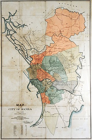
This is an overview of current and former national capital cities in the Philippines, spanning from the Spanish colonial period to the current Fifth Philippine Republic. The current capital city, Manila, has been the country's capital throughout most of its history and regained the title through a presidential order in 1976, with Metro Manila serving as the National Capital Region (NCR) since 1978.

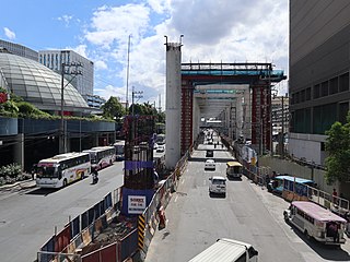
Circumferential Road 3 (C-3), informally known as the C-3 Road, is a network of roads and bridges that all together form the third beltway of Metro Manila in the Philippines. Spanning some 10.8 kilometers (6.7 mi), it connects the cities of Caloocan, Navotas, Quezon City, and San Juan.

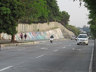
Samson Road is a major east–west street in Caloocan, northern Metro Manila, Philippines. The road is a continuation of Epifanio de los Santos Avenue (EDSA), linked to it via the Bonifacio Monument Roundabout (Monumento) to form a single through route. These roads form part of Circumferential Road 4 (C-4) of the Metro Manila's arterial road network, National Route 120 of the Philippine highway network, and Asian Highway 26 of the Asian highway network.
Metro Manila, the capital region of the Philippines, is a large metropolitan area that has several levels of subdivisions. Administratively, the region is divided into seventeen primary local government units with their own separate elected mayors and councils who are coordinated by the Metropolitan Manila Development Authority, a national government agency headed by a chairperson directly appointed by the Philippine president. The cities and municipality that form the region's local government units are further divided into several barangays or villages which are headed by an elected barangay captain and barangay council.
North Avenue is a major road located in Quezon City within the Diliman area of northeastern Metro Manila, Philippines. It runs east–west through barangays Bagong Pag-asa, Project 6, and Vasra, forming the northern part of the North Triangle area. The street is located in Quezon City's mixed-use and government area, known for its malls, condominiums, hotels, and the upcoming QC CBD. It is also home to SM North EDSA, Trinoma, and Ayala Malls Vertis North located on the avenue's junction with Epifanio de los Santos Avenue (EDSA). The entire avenue is designated as National Route 173 (N173) of the Philippine highway network.

Timog Avenue is a major road located in Quezon City within the Diliman area of northeastern Metro Manila, Philippines. It runs east–west through the southern edge of the barangay of South Triangle and is used to be named in English as South Avenue. The street is located in Quezon City's entertainment area, known for its trendy restaurants, bars and karaoke and comedy clubs. It is also home to the GMA Network Center studios located on the avenue's junction with Epifanio de los Santos Avenue (EDSA). The entire avenue is designated as National Route 172 (N172) of the Philippine highway network.

West Avenue is a major road located in Quezon City within the Diliman area of northeastern Metro Manila, Philippines. It runs north–south through the western edge of the barangay of West Triangle. The street is located in Quezon City's commercial-residential area, known for its restaurants, car shops, schools, and villages. It is also home to the old Delta theater located on the avenue's junction with Quezon Avenue. The avenue is a component of National Route 171 (N171) of the Philippine highway network.

East Avenue is a major street located within the Diliman area of Quezon City, Philippines. It runs north–south through the eastern edge of Triangle Park. The street is located in Quezon City's government area, known for different national and local government institutions, offices, and hospitals. It is also home to the Quezon City Hall Complex located on the avenue's junction with Elliptical Road. The entire avenue is designated as National Route 174 (N174) of the Philippine highway network.
Greater Manila, officially the City of Greater Manila and sometimes referred to as the Greater Manila Area (GMA), was a chartered city that existed during the Japanese occupation of the Philippines in World War II. Governed by the Commonwealth of the Philippines, it served as a model for the present-day Metro Manila and the administrative functions of the governor of Metro Manila—both established three decades later during the administration of President Ferdinand Marcos.

Bagong Pag-asa, also known as the Magsaysay District, is an administrative division in eastern Metro Manila. It is an urban barangay of Quezon City with low-density housing and is known for its shopping malls, transport hubs and office buildings.

Krus na Ligas is a barangay in Diliman, Quezon City in the Philippines. It is located within the premises of the University of the Philippines Diliman. It has a population of 21,287 based on the census conducted in 2020.
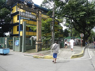
U.P. Campus is a barangay in Quezon City, Philippines. As its name suggests, a large part of the barangay is occupied by the main Diliman campus of the University of the Philippines (UP). UP Diliman, the university campus itself, covers seven other barangays in Quezon City, namely Krus na Ligas, San Vicente, Botocan, Culiat, Old Capitol Site, Pansol, and Vasra.

