
The Missouri River is a river in the Central and Mountain West regions of the United States. The nation's longest, it rises in the eastern Centennial Mountains of the Bitterroot Range of the Rocky Mountains of southwestern Montana, then flows east and south for 2,341 miles (3,767 km) before entering the Mississippi River north of St. Louis, Missouri. The river drains semi-arid watershed of more than 500,000 square miles (1,300,000 km2), which includes parts of ten U.S. states and two Canadian provinces. Although a tributary of the Mississippi, the Missouri River is slightly longer and carries a comparable volume of water. When combined with the lower Mississippi River, it forms the world's fourth-longest river system.

Montana is a landlocked state in the Mountain West subregion of the Western United States. It borders Idaho to the west, North Dakota to the east, South Dakota to the southeast, Wyoming to the south, and the Canadian provinces of Alberta, British Columbia, and Saskatchewan to the north. It is the fourth-largest state by area, the eighth-least populous state, and the third-least densely populated state. Its capital is Helena, while the most populous city is Billings. The western half of the state contains numerous mountain ranges, while the eastern half is characterized by western prairie terrain and badlands, with smaller mountain ranges found throughout the state.

The United States Census Bureau (USCB), officially the Bureau of the Census, is a principal agency of the U.S. Federal Statistical System, responsible for producing data about the American people and economy. The Census Bureau is part of the U.S. Department of Commerce and its director is appointed by the President of the United States. Currently, Rob Santos is the Director of the U.S. Census Bureau and Dr. Ron Jarmin is the Deputy Director of the U.S. Census Bureau

Bismarck is the capital of the U.S. state of North Dakota and the county seat of Burleigh County. It is the state's 2nd most populous city, after Fargo. The population was 73,622 at the 2020 census, and was estimated to be 74,445 in 2022, while its metropolitan population was 133,626. In 2020, Forbes magazine ranked Bismarck as the seventh fastest-growing small city in the United States.

Stark County is a county in the U.S. state of North Dakota. As of the 2020 census, the population was 33,646, making it the 7th most populous county in North Dakota. Its county seat is Dickinson.

McKenzie County is a county in the U.S. state of North Dakota. As of the 2020 census, the population was 14,704. Its county seat is Watford City.

Golden Valley County is a county in the U.S. state of North Dakota. As of the 2020 census, the population was 1,736, making it the fourth-least populous county in North Dakota. The county seat is Beach.

Bowman County is a county in the U.S. state of North Dakota. As of the 2020 census, the population was 2,993. Its county seat is Bowman.
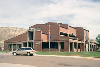
Billings County is a county in the U.S. state of North Dakota. As of the 2020 census, the population was 945, making it the second-least populous county in North Dakota. Its county seat and only incorporated place is Medora.

Billings Township is a civil township of Gladwin County in the U.S. state of Michigan. As of the 2020 census, the township population was 2,318.

Billings is the most populous city in the U.S. state of Montana, with a population of 117,116 as of the 2020 census. Located in the south-central portion of the state, it is the seat of Yellowstone County and the principal city of the Billings Metropolitan Area, which had a population of 184,167 in the 2020 census. With one of the largest trade areas in the United States, Billings is the trade and distribution center for much of Montana east of the Continental Divide. Billings is also the largest retail destination for much of the same area. The Billings Chamber of Commerce claims the area of commerce covers more than 125,000 square miles (320,000 km2). In 2009, it was estimated to serve over 500,000 people.

Medora is a city in Billings County, North Dakota, United States. The only incorporated place in Billings County, it is also the county seat. Much of the surrounding area is part of either Little Missouri National Grassland or Theodore Roosevelt National Park. The population was 121 at the 2020 census. It is part of the Dickinson Micropolitan Statistical Area.

Dickinson is a city in and the county seat of Stark County, North Dakota, United States. The population was 25,679 at the 2020 census, and was estimated to be 24,979 in 2022, making it the 7th most populous city in North Dakota. Dickinson is home to the Ukrainian Cultural Institute, which has a museum and holds events year round for the local Ukrainian community. Western North Dakota has a high concentration of people of Ukrainian descent.
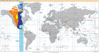
UTC−06:00 is an identifier for a time offset from UTC of −06:00. In North America, it is observed in the Central Time Zone during standard time, and in the Mountain Time Zone during the other eight months. Several Latin American countries and a few other places use it year-round.

There are 459 properties and historic districts listed on the National Register of Historic Places in North Dakota. There are listings in 52 of North Dakota's 53 counties.
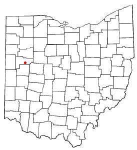
Fryburg is an unincorporated community located in central Pusheta Township, Auglaize County, Ohio, United States.

The Cottonwood River is a tributary of the Minnesota River, 152 miles (245 km) long, in southwestern Minnesota in the United States. Via the Minnesota River, it is part of the watershed of the Mississippi River, draining an area of 1,313 square miles (3,400 km2) in an agricultural region. The river's name is a translation of the Dakota name for the river, Wáǧa Ožú Wakpá, for the cottonwood tree groves, which are common along prairie rivers. It has also been known historically as the Big Cottonwood River.
Gorham is an unincorporated community and ghost town in Billings County, North Dakota, United States. The community was founded c. 1899 and became heavily populated by Ukrainian immigrants. Gorham served as a hub for the rural community, containing a Ukrainian Catholic church, general store, post office, and other businesses. The town was officially abandoned in 1972, although rural farms still exist in the locale.

Sully Springs is an unincorporated area and ghost town in Billings County, North Dakota, United States. It was established along the Northern Pacific Railroad tracks and named for General Alfred Sully, who had camped in the area.
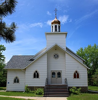
Ukraina is a ghost town in Billings County, North Dakota, United States. In the early 20th century, was established by Ukrainian immigrants, who also established the nearby community of Gorham. It was named after the immigrants' homeland of Ukraine. Ukraina was the site of two churches, one Ukrainian Catholic and the other Eastern Orthodox, used by the local Ukrainian community. By 1949, the settlement had been abandoned and its churches moved to Gorham and Fairfield.


