
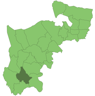
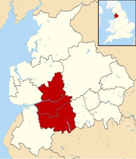
Lancashire is a county in North West England. Lancashire is a historic, ceremonial and non-metropolitan county and the county boundaries differ between these different forms. Its county town is Lancaster. The non-metropolitan county was created by the Local Government Act 1972 and is administered by the Lancashire County Council and twelve district councils. Its administrative centre is Preston. The ceremonial county has a population of 1,449,300 and an area of 1,189 square miles (3,080 km2).

Lititz is a borough in Lancaster County, Pennsylvania, 9 miles (14 km) north of the city of Lancaster. As of the 2020 census, it had a population of 9,370.

Juniata County is a county located in the U.S. state of Pennsylvania. At the 2010 census, the population was 24,636. Its county seat is Mifflintown. The county was created on March 2, 1831, from part of Mifflin County and named for the Juniata River.

Hopewell is a borough in Mercer County, New Jersey, United States. This historical settlement is located within the heart of the Raritan Valley region. As of the 2010 United States Census, the borough's population was 1,922, reflecting a decline of 113 (-5.6%) from the 2,035 counted in the 2000 Census, which had in turn increased by 67 (+3.4%) from the 1,968 counted in the 1990 Census.

Wexham is a civil parish in the county of Buckinghamshire in southern England. It is on the boundary of the unitary authority of Slough, its post town. Wexham Park Hospital is a large hospital on the parish border and Burnham Beeches, a forest takes in small parts of its northern land.

The Metropolitan Borough of Finsbury was a Metropolitan borough within the County of London from 1900 to 1965, when it was amalgamated with the Metropolitan Borough of Islington to form the London Borough of Islington.

The Metropolitan Borough of Hackney was a Metropolitan borough of the County of London from 1900 to 1965. Its area became part of the London Borough of Hackney.

The Metropolitan Borough of Stoke Newington was a metropolitan borough in the County of London between 1900 and 1965 when it became part of the London Borough of Hackney.

Hornchurch was a local government district in southwest Essex from 1926 to 1965, formed as an urban district for the civil parish of Hornchurch. It was greatly expanded in 1934 with the addition of Cranham, Great Warley, Rainham, Upminster and Wennington; and in 1935 by gaining North Ockendon. Hornchurch Urban District Council was based at Langtons House in Hornchurch from 1929. The district formed a suburb of London and with a population peaking at 131,014 in 1961, it was one of the largest districts of its type in England. It now forms the greater part of the London Borough of Havering in Greater London.

Wembley was an urban district and later a municipal borough in Middlesex, England from 1894 to 1965.
Feltham was an urban district in the former county of Middlesex, England from 1904 to 1965. As Middlesex was disbanded is 1965, Feltham now is a part of Greater London.
Central Lancashire is an area of Lancashire, England.

Sutton and Cheam was a local government district in north east Surrey, England from 1882 to 1965.

Wanstead and Woodford was a local government district from 1934 to 1965 in southwest Essex, England. A merger of two former urban districts, it was suburban to London and part of the Metropolitan Police District.
Preston was a rural district in Lancashire, England from 1894 to 1974. It surrounded Preston on the north, west and east sides.

Newton-with-Scales is a village in the county of Lancashire and in the Borough of Fylde. It is situated on the A583 road, 5 miles (8 km) from Preston and 11 miles (18 km) from Blackpool, in the civil parish of Newton-with-Clifton. It has a park situated on School Lane, a restaurant / pub called the Bell and Bottle, a primary school called Newton Bluecoats, a shop called The convenience store which also has a Post Office. On the main road out of the village you will also find a Petrol Station and an Indian Restaurant called Ali Raj.
Preston Candover is a village and large civil parish in Hampshire, England. It has two churches, only one of which is still in use. Its nearest town is Basingstoke, approximately 4.5 miles (7.2 km) away. It has an acreage of 3,457 acres (13.99 km2), which lies on comparatively low ground, south of the high country round the surrounding villages of Farleigh Wallop and Nutley, and north-west of that which rises to Wield and beyond to Bentworth. The village itself lies on the lowest ground towards the west of the parish on the road which comes northeast from Northington and the two other Candovers, and runs across the parish to enter Nutley at Axford and continues uphill to Farleigh Wallop and then to Basingstoke.
Preston Municipal Borough, also known as the County Borough of Preston from 1889, was a local government district coterminate with the town of Preston in Lancashire, northwest England from 1836 to 1974.

Chilton Candover is a village in Hampshire, England. It has an acreage of 1,451 acres (5.87 km2) and sits in the valley of the River Alre. The village is situated on the main road from Basingstoke to Winchester, and consists of a few scattered houses built of brick and roofed with slate, thatch and tiles. To the north lies an underground churchyard enclosed by a flint stone wall, now abandoned and overgrown with weeds.
Nutley is a small village and civil parish in the Basingstoke and Deane district of Hampshire, England. It is located approximately 5.6 miles (9.0 km) south-west from Basingstoke, just off the B3046 road. The parish has an acreage of 1,524 acres (617 ha) with 74 acres (30 ha) made up of permanent grass and 386 acres (156 ha) of woodland.
