
Hail is a form of solid precipitation. It is distinct from ice pellets, though the two are often confused. It consists of balls or irregular lumps of ice, each of which is called a hailstone. Ice pellets generally fall in cold weather, while hail growth is greatly inhibited during cold surface temperatures.

The National Weather Service (NWS) is an agency of the United States federal government that is tasked with providing weather forecasts, warnings of hazardous weather, and other weather-related products to organizations and the public for the purposes of protection, safety, and general information. It is a part of the National Oceanic and Atmospheric Administration (NOAA) branch of the Department of Commerce, and is headquartered in Silver Spring, Maryland, within the Washington metropolitan area. The agency was known as the United States Weather Bureau from 1890 until it adopted its current name in 1970.

NEXRAD or Nexrad is a network of 160 high-resolution S-band Doppler weather radars operated by the National Weather Service (NWS), an agency of the National Oceanic and Atmospheric Administration (NOAA) within the United States Department of Commerce, the Federal Aviation Administration (FAA) within the Department of Transportation, and the U.S. Air Force within the Department of Defense. Its technical name is WSR-88D.
WSR-57 radars were the USA's main weather surveillance radar for over 35 years. The National Weather Service operated a network of this model radar across the country, watching for severe weather.

Storm chasing is broadly defined as the deliberate pursuit of any severe weather phenomenon, regardless of motive, but most commonly for curiosity, adventure, scientific investigation, or for news or media coverage. A person who chases storms is known as a storm chaser or simply a chaser.

Weather radar, also called weather surveillance radar (WSR) and Doppler weather radar, is a type of radar used to locate precipitation, calculate its motion, and estimate its type. Modern weather radars are mostly pulse-Doppler radars, capable of detecting the motion of rain droplets in addition to the intensity of the precipitation. Both types of data can be analyzed to determine the structure of storms and their potential to cause severe weather.

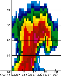
A hook echo is a pendant or hook-shaped weather radar signature as part of some supercell thunderstorms. It is found in the lower portions of a storm as air and precipitation flow into a mesocyclone, resulting in a curved feature of reflectivity. The echo is produced by rain, hail, or even debris being wrapped around the supercell. It is one of the classic hallmarks of tornado-producing supercells. The National Weather Service may consider the presence of a hook echo coinciding with a tornado vortex signature as sufficient to justify issuing a tornado warning.
The National Severe Storms Laboratory (NSSL) is a National Oceanic and Atmospheric Administration (NOAA) weather research laboratory under the Office of Oceanic and Atmospheric Research. It is one of seven NOAA Research Laboratories (RLs).
The bounded weak echo region, also known as a BWER or a vault, is a radar signature within a thunderstorm characterized by a local minimum in radar reflectivity at low levels which extends upward into, and is surrounded by, higher reflectivities aloft. This feature is associated with a strong updraft and is almost always found in the inflow region of a thunderstorm. It cannot be seen visually. The BWER has been noted on radar imagery of severe thunderstorms since 1973 and has a lightning detection system equivalent known as a lightning hole.

The Aggie Doppler Radar (ADRAD) is a Doppler weather radar located on the roof of the Eller Oceanography & Meteorology Building on the Texas A&M University campus in College Station, Texas.

ARMOR Doppler weather radar is a C-Band, Dual-Polarimetric Doppler Weather Radar, located at the Huntsville International Airport in Huntsville, Alabama. The radar is a collaborative effort between WHNT-TV and the University of Alabama in Huntsville. Live data for the radar is only available to a limited audience, such as UAH employees and NWS meteorologists. All ARMOR data is archived at the National Space Science and Technology Center located on the UAH campus.
Volumetric Imaging and Processing of Integrated Radar, known by the acronym VIPIR, is an analysis and display program for Doppler weather radar, created and sold by Baron Services. This software allows improved analysis of radar data for private users, in particular television stations, similar to the Weather Decision Support System program used by the National Weather Service.
Convective storm detection is the meteorological observation, and short-term prediction, of deep moist convection (DMC). DMC describes atmospheric conditions producing single or clusters of large vertical extension clouds ranging from cumulus congestus to cumulonimbus, the latter producing thunderstorms associated with lightning and thunder. Those two types of clouds can produce severe weather at the surface and aloft.

Vertically integrated liquid (VIL) is an estimate of the total mass of precipitation in the clouds. The measurement is obtained by observing the reflectivity of the air which is obtained with weather radar.

A tornadic vortex signature, abbreviated TVS, is a Pulse-Doppler radar weather radar detected rotation algorithm that indicates the likely presence of a strong mesocyclone that is in some stage of tornadogenesis. It may give meteorologists the ability to pinpoint and track the location of tornadic rotation within a larger storm, but it is not an important feature in the National Weather Service's warning operations.
NetCDF is a set of software libraries and self-describing, machine-independent data formats that support the creation, access, and sharing of array-oriented scientific data. The project homepage is hosted by the Unidata program at the University Corporation for Atmospheric Research (UCAR). They are also the chief source of netCDF software, standards development, updates, etc. The format is an open standard. NetCDF Classic and 64-bit Offset Format are an international standard of the Open Geospatial Consortium.

OU-PRIME was an advanced Doppler weather radar. It was completed in January 2009 after a ten-month construction period and commissioned on April 4, 2009. It is operated by the Advanced Radar Research Center (ARRC) at the University of Oklahoma (OU). The radar was manufactured by Enterprise Electronics Corporation to provide OU students and faculty a platform for research and education in the field of radar meteorology. This C-band polarimetric radar has some of the highest resolution data of any C-band weather radar in the United States.
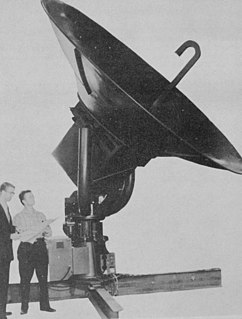
Terminal Doppler Weather Radar (TDWR) is a Doppler weather radar system with a three-dimensional "pencil beam" used primarily for the detection of hazardous wind shear conditions, precipitation, and winds aloft on and near major airports situated in climates with great exposure to thunderstorms in the United States. As of 2011, all were in-service with 45 operational radars, some covering multiple airports in major metropolitan locations, across the United States & Puerto Rico. Several similar weather radars have also been sold to other countries such as China. Funded by the United States Federal Aviation Administration (FAA), TDWR technology was developed in the early 1990s at Lincoln Laboratory, part of the Massachusetts Institute of Technology, to assist air traffic controllers by providing real-time wind shear detection and high-resolution precipitation data.
Baron Services is a weather technology company based in Huntsville, Alabama, United States. The company develops weather systems that aid in the detection and dissemination of weather information to customers in the broadcast, government, aviation, marine and automotive industries. These technologies include weather tracking software, Doppler weather radar, systems integration, and personal alerting services, among others. The company holds numerous U.S. patents for weather technology.
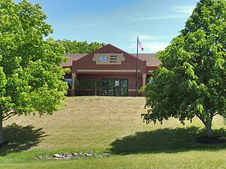
The National Weather Service Gray/Portland, Maine (GYX) is a local office of the National Weather Service responsible for monitoring weather conditions over western Maine and all of New Hampshire. It is situated in Gray, Maine, in the metropolitan area of Portland, in a rural setting.
