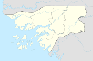
Guinea-Bissau, officially the Republic of Guinea-Bissau, is a country in West Africa that covers 36,125 square kilometres (13,948 sq mi) with an estimated population of 2,026,778. It borders Senegal to its north and Guinea to its southeast.
The region now known as Guinea-Bissau, in West Africa, has been inhabited by humans for thousands of years. During the 13th century CE, it was a province of the Mali Empire which later became independent as the empire of Kaabu. The Portuguese Empire claimed the region during the 1450s, but its control was limited to several forts along the coast during most of this period; it gained control of the mainland after a series of "pacification campaigns" from 1912 to 1915, which used military forces to violently crush local resistance. The offshore Bijagos Islands were not colonized until 1936. Guinea-Bissau gained independence from Portugal in 1974. The introduction of multi-party politics in 1991 led to the first multi-party elections in 1994. A civil war broke out in 1998, which lasted until the following year.

Banjul, officially the City of Banjul, is the capital of The Gambia. It is the centre of the eponymous administrative division which is home to an estimated 400,000 residents, making it The Gambia's largest and most densely populated metropolitan area. The city Banjul is located on St Mary's Island, where the Gambia River enters the Atlantic Ocean.

The Mandinka or Malinke are a West African ethnic group primarily found in southern Mali, The Gambia, southern Senegal and eastern Guinea. Numbering about 11 million, they are the largest subgroup of the Mandé peoples and one of the largest ethnolinguistic groups in Africa. They speak the Manding languages in the Mande language family, which are a lingua franca in much of West Africa. Virtually all of Mandinka people are adherent to Islam, mostly based on the Maliki jurisprudence. They are predominantly subsistence farmers and live in rural villages. Their largest urban center is Bamako, the capital of Mali.

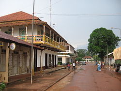
Gabú region is the easternmost region in Guinea-Bissau. Its capital is Gabú. The region borders Senegal to the north, Guinea to the east and south and the Guinea-Bissau regions of Tombali and Bafatá to the west. It covers an area of 9,150 km2, making it the largest of Guinea-Bissau's administrative regions. It is an inland region covered with savannah or light savannah woodland and receives an annual rainfall of more than 2,000 mm (79 in).
Articles related to Guinea-Bissau include:

Labé is the main city and administrative capital of the Fouta Djallon region of Guinea. It has a population of about 200,000. It is the second largest city in the country after the capital Conakry in terms of economic importance. Labé is situated some 450 kilometres or 280 miles northeast of Conakry close to the geographic centre of Guinea.
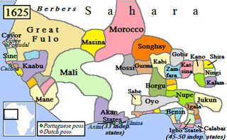
Kaabu (1537–1867), also written Gabu, Ngabou, and N'Gabu, was a federation of Mandinka kingdoms in the Senegambia region centered within modern northeastern Guinea-Bissau, large parts of today's Gambia, and extending into Koussanar, Koumpentoum, and the Casamance in Senegal.
The Empire of Great Fulo, also known as the Denanke Kingdom or Denianke Kingdom, was a Pulaar kingdom of Senegal, which dominated the Futa Toro region from the early 16th century to 1776.
The Bainuk people are an ethnic group that today lives primarily in Senegal as well as in parts of Gambia and Guinea-Bissau.

Canquelifá, sometimes spelled Kankelefa, is a village in the Gabú Region of north-eastern Guinea-Bissau. It lies to the northwest of Buruntuma.
The Battle of Kansala or Turban Keloo was the siege of the capital of the Kaabu federation by the Imamate of Futa Jallon, allied with rebellious Fula people from Kaabu itself. The battle, which saw the town completely destroyed, ended Mandinka hegemony over Africa’s Atlantic coast begun by the Mali Empire.
Guelowar, also spelled Gelwar, Guelwar, Guelware, Gueleware or Gueloware, was a maternal dynasty in the pre-colonial Serer kingdoms of Sine and Saloum. They were from the Mandinka ethnic group. The offspring of Mandinka women and Serer men became the kings of Sine and Saloum. The dynasty lasted from the mid-14th century to 1969, the year both kings died.

Fuladu or Fuladugu is a historic region and former Fula kingdom in the Upper Casamance, in the south of Senegal, and including certain areas in The Gambia and Guinea-Bissau. It was the last independent pre-colonial state in the area, ceasing to exist in 1903.
Tenguella was a Fula silatigi or chief who founded a short-lived state in the upper Senegal river valley, a precursor of the Empire of Great Fulo. He was referred to as the Great Fulo or Great king of the Fulos in Portuguese documents of the time.

Manding, Manden or even Mandé is a region located in West Africa, a space between southern Mali and eastern Guinea. It is the historic home of the Mandinka community.
The Tenda or Tanda are an ethnolinguistic group living in the southern Senegal, northeastern Guinea-Bissau, and northern Guinea, comprising the Bassari, the Konyagui, the Bedik, and the Badiaranke.
The Nyancho were a royal maternal dynasty that ruled the West African empire of Kaabu.
Niani was a Mandinka kingdom located on the north bank of the Gambia River from approximately the 14th to the late 19th century in what is now The Gambia and Senegal.
The Soninke-Marabout Wars were a series of 19th-century civil wars across southern Senegambia pitting the traditional ruling classes of various states, mostly animist or only nominally Muslim, against Islamic reformers led by the marabout class. French and British forces frequently became involved in these conflicts, providing them an opportunity to extend colonial power into the hinterland.