
Stafford is a market town and the county town of Staffordshire, England. It is located about 15 miles (24 km) south of Stoke-on-Trent, 15 miles (24 km) north of Wolverhampton, and 24 miles (39 km) northwest of Birmingham. The town had a population of 71,673 in 2021, and is the main settlement within the larger Borough of Stafford, which had a population of 136,837 in 2021.
South Staffordshire is a local government district in Staffordshire, England. Its council is based in Codsall. Other notable settlements include Brewood, Cheslyn Hay, Coven, Essington, Featherstone, Four Ashes, Great Wyrley, Huntington, Kinver, Landywood, Penkridge, Perton, Wedges Mills, Weston-under-Lizard and Wombourne. The district covers a largely rural area lying immediately to the west and north-west of the West Midlands conurbation.

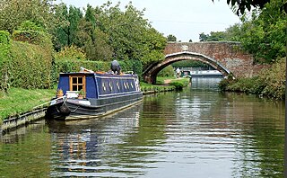
Penkridge is a village and civil parish in South Staffordshire District in Staffordshire, England. It is to the south of Stafford, north of Wolverhampton, west of Cannock, east of Telford and south-east of Newport.

Kidsgrove railway station serves the town of Kidsgrove in Staffordshire, England. The station is 7.5 miles (12.07 km) north of Stoke-on-Trent. The station is served by trains on the Crewe–Derby line which is also a community rail line known as the North Staffordshire line. The station is owned by Network Rail and managed by East Midlands Railway.

The A449 is a major road in the United Kingdom. It runs north from junction 24 of the A48 road at Newport in South Wales to Stafford in Staffordshire.

Brewood is an ancient market town in the civil parish of Brewood and Coven, in the South Staffordshire district, in the county of Staffordshire, England. Brewood lies near the River Penk, 8 miles (13 km) north of Wolverhampton and 11 miles (18 km) south of Stafford. Brewood is about 3 miles (4.8 km) east of the county border with Shropshire.

Stoke-on-Trent railway station is a mainline railway station serving the city of Stoke-on-Trent, on the Stafford to Manchester branch of the West Coast Main Line. It also provides an interchange between local services running through Cheshire, Staffordshire and Derbyshire.

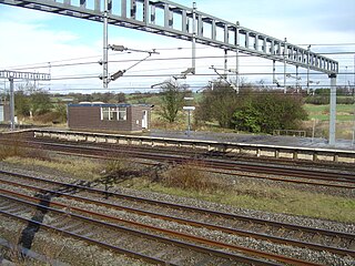
Penkridge railway station is a railway station serving the village of Penkridge in Staffordshire, England.
Doxey is a village and civil parish in the borough of Stafford in Staffordshire, England. It is a north-western suburb of Stafford. The village became a civil parish on 1 April 2005.

Essington is a village and civil parish in the South Staffordshire, district, in Staffordshire, England, near the city of Wolverhampton and towns of Walsall, Bloxwich, Cannock and Brewood. The villages of Cheslyn Hay, Great Wyrley, Coven, Penkridge and Featherstone are also nearby. The village forms part of the Staffordshire/West Midlands border. The parish includes the hamlet of Springhill. In 2021 the parish had a population of 5200.
Norton Bridge railway station was a railway station located on the West Coast Main Line and served both the village of Norton Bridge and the town of Eccleshall in Staffordshire, England.
The Stafford–Manchester line is a major railway line branching from the West Coast Main Line serving Stafford, Stone, Stoke-on-Trent, Kidsgrove, Congleton, Macclesfield, Cheadle Hulme, Stockport and Manchester.

The M54 is a 23-mile-long (37 km) east-west motorway in the counties of Shropshire and Staffordshire, England. It is also referred to as the Telford motorway, after the road's primary westbound destination, the town of Telford. It cost £65 million to construct, and is two-lane dual carriageway for the majority of its length, with sections of three-lane.

Gailey railway station was a railway station built by the Grand Junction Railway in 1837. It served the small village of Gailey, Staffordshire, 7 miles north of Wolverhampton City Centre, and was located near to the junction of the A5 and A449 roads.

Four Ashes railway station was a railway station built by the Grand Junction Railway in 1837. It served the small village of Four Ashes, Staffordshire, 6 miles north of Wolverhampton City Centre, and was located near to the A449 road, on Station Drive. It was also the closest station to the villages of Coven and Featherstone as well as the town of Brewood.

The Four Counties Ring is a canal ring which links the four English counties of Cheshire, Staffordshire, Shropshire and West Midlands.

Coven is a village in the district of South Staffordshire, England, near the border with Wolverhampton. Together with Brewood it forms part of the parish of Brewood & Coven.

Black Ladies Priory was a house of Benedictine nuns, located about 4 km west of Brewood in Staffordshire, on the northern edge of the hamlet of Kiddemore Green. Founded in the mid-12th century, it was a small, often struggling, house. It was dissolved in 1538, and a large house was built on the site in Tudor and Jacobean styles by the Giffard family of Chillington Hall. Much of this is incorporated in the present Black Ladies, a large, Grade II*-listed, private residence.

Penkridge is a village and parish in Staffordshire with a history stretching back to the Anglo-Saxon period. A religious as well as a commercial centre, it was originally centred on the Collegiate Church of St. Michael and All Angels, a chapel royal and royal peculiar that maintained its independence until the Reformation. Mentioned in Domesday, Penkridge underwent a period of growth from the 13th century, as the Forest Law was loosened, and evolved into a patchwork of manors of greatly varying size and importance, heavily dependent on agriculture. From the 16th century it was increasingly dominated by a single landed gentry family, the Littletons, who ultimately attained the Peerage of the United Kingdom as the Barons Hatherton, and who helped modernise its agriculture and education system. The Industrial Revolution inaugurated a steady improvement in transport and communications that helped shape the modern village. In the second half of the 20th century, Penkridge grew rapidly, evolving into a mainly residential area, while retaining its commercial centre, its links with the countryside and its fine church.

Stone, Great Wyrley and Penkridge is a constituency of the House of Commons in the UK Parliament. Further to the completion of the 2023 Periodic Review of Westminster constituencies, it was first contested at the 2024 general election and is represented by Sir Gavin Williamson of the Conservative Party.

