Gailtal Alps

Last updated
Gailtal Alps
German: Gailtaler Alpen, Drauzug
Grosse Sandspitze 1.jpg
Große Sandspitze, the highest peak in the range
Highest point
Peak Große Sandspitze
Elevation 2,770 m (9,090 ft)
Coordinates 46°46′0″N12°48′42″E / 46.76667°N 12.81167°E / 46.76667; 12.81167 Coordinates: 46°46′0″N12°48′42″E / 46.76667°N 12.81167°E / 46.76667; 12.81167
Dimensions
Length100 km (62 mi)
Geography
Alps location map (Gailtaler Alpen).png
The Gailtal Alps (in red) within the Alps.
The borders of the range according to
Alpine Club classification of the Eastern Alps
Country Austria
States Carinthia and Tyrol (East Tyrol)
Parent range Southern Limestone Alps
Carnic and Gailtal Alps and Alps
Geology
Orogeny Alpine orogeny
Type of rock Limestone

The Gailtal Alps (German : Gailtaler Alpen or Drauzug), is a mountain range of the Southern Limestone Alps in Austria. It rises between the River Drava (Drau) and the Gail valley (in southwestern Carinthia) and through the southern part of East Tyrol. Its western group called "Lienz Dolomites" (Lienzer Dolomiten), is sometimes counted as part of this range and sometimes seen as separate.

Contents

Classification

According to the Alpine Club classification of the Eastern Alps (AVE) the Gailtal Alps (No. 56) are subdivided into the Drauzug proper and Lienz Dolomites subgroups, while in common parlance the umbrella term Drauzug conversely applies to the whole Limestone Alps range between the Drava and Gail rivers, including the Gailtal Alps and the Lienz Dolomites. In traditional geography according to Eduard Suess and Leopold Kober, Drauzug or Drau-Save-Zug denoted all Southern Limestone Alps ranges stretching along the Drava River, from the Lienz Dolomites in the west to the Karawanks in the east.

Located south of the broad Drava Valley, the Gailtal Alps orographically count as part of the Southern Limestone Alps. However, they rise north of the Periadriatic Seam an therefore geologically do not rank among the Southern Alps ranges. In regard to their orogenesis, they represent the remnants of the limestone nappes which had been moved northwards across the Central Eastern Alps to form the Northern Limestone Alps.

Despite their name, the Lienz Dolomites are not made up of dolomite, though the steep rugged karst topography resembles the South Alpine Dolomite rock formations. The northern Latschur group with Mt. Goldeck near Spittal an der Drau does not consist of limestone rocks, but is a crystalline basement massif.
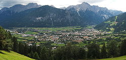
Geography

Mt Reisskofel Comptonhuette mit Reisskofel 1 2010.jpg
Mt Reißkofel

The 100 km long range, which narrows in the west, stretches between the Gail in the south and the Drava in the north. In a trough between the Gailtal Alps and Mt. Goldeck lies the Weißensee at 930 metres (3,050 ft), the highest lake for bathing in Austria.

Neighbouring ranges

Based on the AVE classification, the adjacent ranges are:

Subdivisions

The Gailtal Alps can be divided into five massifs in east–west direction, separated by draws and the Weissensee longitudinal valley: [1]

Lienz Dolomites and Lienz Lienz gesamt.jpg
Lienz Dolomites and Lienz


Literature

Related Research Articles

Drava

The Drava or Drave is a river in southern Central Europe. With a length of 710 kilometres (440 mi), 724 kilometres (450 mi) including the Sextner Bach source, it is the fifth or sixth longest tributary of the Danube, after the Tisza, Sava, Prut, Mureș and perhaps Siret. Its source is near the market town of Innichen, in the Puster Valley of South Tyrol, Italy. The river flows eastwards through East Tirol and Carinthia in Austria into the Styria region of Slovenia. It then turns southeast, passing through Croatia and, after merging with its main tributary Mur, forms most of the border between Croatia and Hungary, before it joins the Danube near Osijek.

Kreuzeck group

The Kreuzeck Group is a mountain range of the Central Eastern Alps. It may be considered either a separate range or part of the larger High Tauern chain. Administratively, the range belongs to the Austrian states of Carinthia and, in the westernmost part, Tyrol.

High Tauern A mountain range of the eastern Alps

The High Tauern are a mountain range on the main chain of the Central Eastern Alps, comprising the highest peaks east of the Brenner Pass. The crest forms the southern border of the Austrian states of Salzburg, Carinthia and East Tyrol, with a small part in the southwest belongs to the Italian province of South Tyrol. The range includes Austria's highest mountain, the Grossglockner at 3,798 metres (12,461 ft) above the Adriatic.

Gail (river)

Gail is the name of a river in southern Austria, the largest right tributary of the Drava.

Bezirk Spittal an der Drau is an administrative district (Bezirk) in the state of Carinthia, Austria.

Noric Alps

The Noric Alps is a collective term denoting various mountain ranges of the Eastern Alps. The name derives from the ancient Noricum province of the Roman Empire on the territory of present-day Austria and the adjacent Bavarian and Slovenian area.

Periadriatic Seam The border between the Adriatic and European plates

The Periadriatic Seam is a distinct geologic fault in Southern Europe, running S-shaped about 1000 km from the Tyrrhenian Sea through the whole Southern Alps as far as Hungary. It forms the division between the Adriatic plate and the European plate. The term Insubric line is sometimes used to address the whole Periadriatic Seam, but it is more commonly used to mean just a western part of it.

Puster Valley District in Italy

The Puster Valley is one of the largest longitudinal valleys in the Alps that runs in an east-west direction between Lienz in East Tyrol, Austria and Mühlbach near Brixen in South Tyrol, Italy. The South Tyrolean municipalities of the Puster Valley constitute the Puster Valley district.

Kreuzberg Saddle

Kreuzberg Saddle is a high mountain pass across the Gailtal Alps in the Austrian state of Carinthia.

Greifenburg Place in Carinthia, Austria

Greifenburg is a market town in the district of Spittal an der Drau in the Austrian state of Carinthia.

Oberdrauburg Place in Carinthia, Austria

Oberdrauburg is a market town in the district of Spittal an der Drau at the western rim of the Austrian state of Carinthia.

Tauern Autobahn

The Tauern Autobahn is an autobahn (motorway) in Austria. It starts at the Salzburg junction with the West Autobahn (A1), runs southwards, crosses the Tauern mountain range on the main chain of the Alps and leads to the Süd Autobahn (A2) and Karawanken Autobahn (A11) at Villach in Carinthia.

Weissensee (Carinthia)

The Weissensee is a lake in the Austrian state of Carinthia within the Gailtal Alps mountain range. The highest situated Carinthian bathing lake shares its name with the municipality of Weissensee on the northern and southern shore.

Schober group

The Schober group is a sub-range of the Hohe Tauern mountains in the Central Eastern Alps, on the border between the Austrian states of Tyrol and Carinthia. Most of the range is located inside Hohe Tauern national park. It is named after Mt. Hochschober, 3,242 metres (10,636 ft), though its highest peak is Mt. Petzeck at 3,283 metres (10,771 ft).

Ankogel Group

The Ankogel Group is a sub-group of the Central Eastern Alps. Together with the Goldberg Group, the Glockner Group, the Schober Group, the Kreuzeck Group, the Granatspitze Group, the Venediger Group, the Villgraten Mountains and the Rieserferner Group it forms the mountain range of the Hohe Tauern.

Carnic and Gailtal Alps

The Carnic and Gailtal Alps is a geographic grouping of mountain ranges belonging to the Southern Limestone Alps. They are located in Austria and Italy.

Große Sandspitze

The Große Sandspitze in Tyrol is 2,770 m (AA) and the highest mountain in the Gailtal Alps, a mountain range of the Southern Limestone Alps. It is located within the subrange of the Lienz Dolomites and is locally called the Sunnspitz.

Lienz Dolomites

The Lienz Dolomites are an alpine mountain range located in East Tyrol and Carinthia, Austria. It lies at the western side of the wider Gailtal Alps and contains its highest peaks. The range lies between the Drau Valley in the north and the Gail Valley to the south.

Reißkofel

The Reißkofel is, at 2,371 metres above the Adriatic (7,779 ft), the highest mountain of the Gailtal Alps east of the Lienz Dolomites. It is situated in the centre of the Gailtal range, part of the Southern Limestone Alps, in the Austrian state of Carinthia.

Latschur

Latschur, at 2,236 m (7,336 ft), is the highest mountain of the Latschur Group in the Gailtal Alps range, in the Austrian state of Carinthia.

References

  1. Hubert Trimmel (1962), Verband österreichischer Höhlenforscher (ed.), Gebirgsgruppengliederung für das österreichische Höhlenverzeichnis (in German), Vienna