
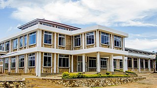
Ludewa District is one of six districts in the Njombe Region in Tanzania, East Africa. Prior to 2012, the district was one of the seven districts of Iringa Region. The town of Ludewa is the administrative seat of the district. A hospital is located in the city. The district is bordered to the north by the Njombe Rural District and Makete District, to the southeast by the Ruvuma Region and to the southwest by the country of Malawi across Lake Nyasa.
Iringa Region is one of Tanzania's 31 administrative regions. The region covers an area of 35,503 km2 (13,708 sq mi). The region is comparable in size to the combined land area of the nation state of Guinea Bissau. Iringa Region is bordered to the east by Morogoro Region and south by Njombe Region. On the west the region is bordered by Mbeya Region. Dodoma Region and Singida Region border Iringa on the north. The regional capital is the city Iringa for which the city is named after. According to the 2022 census, the region has a total population of 1,192,728. Iringa Region is home to Ruaha National Park, Tanzania's second national largest park.
Morogoro Region is one of Tanzania's 31 administrative regions. The region covers an area of 70,624 km2 (27,268 sq mi). The region is comparable in size to the combined land area of the nation state of Ireland. Morogoro Region is bordered to the north by the Manyara Region and Tanga Region, to the east by the Pwani and Lindi Regions, to the south by the Ruvuma Region and to the west by the Iringa Njombe and Dodoma Regions. The regional capital is the municipality of Morogoro. According to the 2022 national census, the region had a population of 3,197,104.
Magu District is one of the seven districts of the Mwanza Region of Tanzania, East Africa. Its administrative centre is the town of Magu on the Simiyu River. It is bordered to the north by Lake Victoria and Busega District, to the east by Bariadi District, to the south by Itilima District, Maswa District, Kwimba District and Misungwi District, and to the west by the city of Mwanza, which consists of Nyamagana District and Ilemela District.
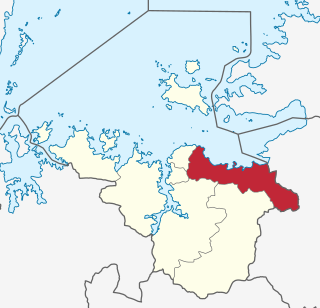
Kilindi is one of eleven administrative districts of Tanga Region in Tanzania. The District covers an area of 6,444 km2 (2,488 sq mi). It is bordered to the east by the Handeni District and Handeni Town Council, to the south west by the Kiteto District and north west by the Simanjiro District of Manyara Region. Kilindi District is bordered to the south by Gairo District and Kilosa District of Morogoro Region. The district created from Handeni District in 2002. The district seat (capital) is the town of Songe. According to the 2022 census, the district has a total population of 398,391.

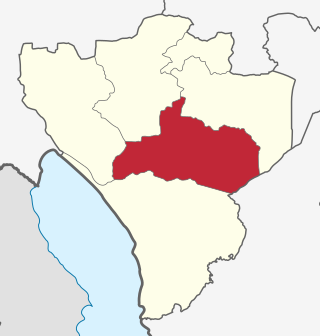
Mufindi District is one of the four districts of the Iringa Region of Tanzania. It is bordered to the north by Kilolo District and Iringa Urban District, to the south by the Njombe Region, to the east by the Morogoro Region and to the west by the Singida Region.

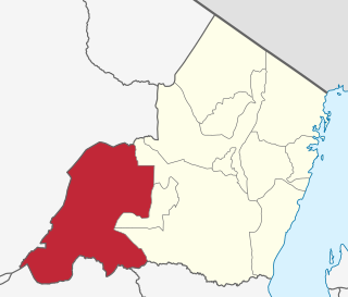
Kilosa District is one of the six districts of the Morogoro Region of Tanzania. Its administrative seat is the town of Kilosa. Kilosa District covers 14,918 square kilometres (5,760 sq mi). It is bordered to the north by the Manyara Region, to the northeast by the Tanga Region, to the east by Mvomero District, to the southeast by Morogoro Rural District, to the south by Kilombero District, to the southwest by the Iringa Region and to the west by the Dodoma Region. Kilosa District is home to Mikumi National Park.

Morogoro Rural District is one of the six districts of the Morogoro Region of Tanzania. Morogoro Rural District covers 19,056 square kilometres (7,358 sq mi). It is bordered to the north and east by the Pwani Region, to the south by Kilombero District, to the southwest by the Kilosa District and to the west by the Mvomero District and the Morogoro Urban District.

Chunya District is one of the seven districts of Mbeya Region, Tanzania. It is bordered to the north by Tabora Region, to the northeast by Singida Region, to the east by Mbarali District, to the south by Mbeya Rural District, and to the west by Songwe District.

Ikungi District is one of the six districts of the Singida Region of Tanzania. It is one of the 20 new districts that were formed in Tanzania since 2010; it was split off from Singida Rural District. Ikungi District is bordered to the north by Iramba District, Singida Urban District and Singida Rural District, to the east by Manyara Region, to the south by Manyoni District and to the west by Tabora Region. Its administrative seat is the town of Ikungi.

Ulanga District is one of the six districts of the Morogoro Region of Tanzania. the administrative seat is in Mahenge. It covers 24,460 square kilometres (9,444 sq mi) of which 4,927 square kilometres (1,902 sq mi) is in forest reserves. Ulanga District is bordered to the north and west by the Kilombero District, to the east by the Lindi Region and to the south by the Ruvuma Region.

Kalambo District is one of the four districts of the Rukwa Region of Tanzania, East Africa. The administrative seat is in Matai. The Kalambo River flows through the district and its mouth on Lake Tanganyika is about 15 km south of the town of Kasanga.

Njombe Rural District is one of the six districts of the Njombe Region of Tanzania, East Africa. Its administrative seat is Njombe town. The 2022 population was 182,127.
Njombe Urban District is one of the six districts of the Njombe Region of Tanzania, East Africa. The administrative seat for the district is in the city of Njombe.
Rubeho is a town and ward in Gairo District in the Morogoro Region of Tanzania, East Africa. As of 2002, the population of the ward was 17,020. Prior to 2012, Rubeho was administered by Kilosa District.
Gairo is a large town and an administrative ward in Gairo District in the Morogoro Region of Tanzania, East Africa. The town is the administrative centre for Gairo District. It is located on the main Dodoma to Dar es Salaam road and is a transshipment point, as well as a shipping point for the agricultural products of the district. As of 2012, the town's population was 22,948,

Morogoro Urban District is one of the six districts of the Morogoro Region of Tanzania. It contains the city Morogoro, capital of the Morogoro Region, and no villages. Morogoro Urban District covers 260 square kilometres (100 sq mi). It is bordered to the east and south by the Morogoro Rural District and to the north and west by Mvomero District

Mkalama District is one of the six districts of the Singida Region of Tanzania. It is one of the 20 new districts that were formed in Tanzania since 2010; it was split off from Iramba District. Mkalama District is bordered to the north by Simiyu Region and Arusha Region, to the east by Manyara Region, to the south by Singida Rural District and to the west by Iramba District.

Bahi District is one of the seven districts of the Dodoma Region of Tanzania. Bahi District is bordered to the north by Chemba District, to the east by Dodoma District and Chamwino District, and to the west by Singida Region. Its administrative seat is the town of Bahi.
